Category:Nederlands Hervormde Kerk, Anloo
Jump to navigation
Jump to search
| Object location | | View all coordinates using: OpenStreetMap |
|---|
church building in Aa en Hunze, Netherlands  | |||||
| Upload media | |||||
| Instance of | |||||
|---|---|---|---|---|---|
| Location | Anloo, Aa en Hunze, Drenthe, Netherlands | ||||
| Street address |
| ||||
| Located on street |
| ||||
| Heritage designation |
| ||||
 | |||||
Nederlands: Magnuskerk, Anloo - Anno 1100
Kerk:
|
This is a category about rijksmonument number 8152
|
Toren:
|
This is a category about rijksmonument number 8153
|
| Address |
|
Media in category "Nederlands Hervormde Kerk, Anloo"
The following 134 files are in this category, out of 134 total.
-
 20191030 Sint Magnuskerk1 van Anloo.jpg 4,032 × 3,024; 2.74 MB
-
 20191030 Sint Magnuskerk2 van Anloo.jpg 5,184 × 3,456; 3.31 MB
-
 20191030 Sint Magnuskerk3 van Anloo.jpg 3,456 × 5,184; 4.78 MB
-
 20191030 Sint Magnuskerk4 van Anloo.jpg 3,456 × 5,184; 3.02 MB
-
 20191030 Sint Magnuskerk5 van Anloo.jpg 1,881 × 2,822; 1.02 MB
-
 20191030 Sint Magnuskerk6 van Anloo.jpg 3,456 × 5,184; 3.67 MB
-
 20191030 Sint Magnuskerk7 van Anloo.jpg 3,456 × 5,184; 3.45 MB
-
 20191030 Sint Magnuskerk8 van Anloo.jpg 3,456 × 5,184; 3.72 MB
-
 20191030 Zicht op Anloo1 met Sint Magnuskerk.jpg 5,184 × 3,456; 3.86 MB
-
 20191030 Zicht op Anloo2 met Sint Magnuskerk.jpg 5,184 × 3,456; 4.55 MB
-
 20191030 Zicht op Anloo3 met Sint Magnuskerk.jpg 5,184 × 3,456; 2.88 MB
-
 20191030 Zicht op Anloo5 met Sint Magnuskerk.jpg 5,184 × 3,456; 5.32 MB
-
 20191030 Zicht op Anloo6 met Sint Magnuskerk.jpg 5,184 × 3,456; 2.46 MB
-
 20191030 Zicht op Anloo7 met Sint Magnuskerk.jpg 5,184 × 3,456; 3.42 MB
-
 Aanzicht - Anloo - 20022668 - RCE.jpg 1,200 × 912; 301 KB
-
 Aanzicht - Anloo - 20022669 - RCE.jpg 1,200 × 916; 299 KB
-
 Aanzicht - Anloo - 20022670 - RCE.jpg 917 × 1,200; 257 KB
-
 Anloo Magnuskerk.jpg 1,296 × 972; 241 KB
-
 Bekroning balustrade bij het orgel - Anloo - 20022721 - RCE.jpg 1,200 × 1,188; 318 KB
-
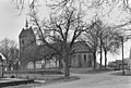
 De Hervormde kerk, gezien vanuit het zuidwesten - Anloo - 20534923 - RCE.jpg 850 × 1,200; 128 KB
-
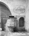
 Doopvont - Anloo - 20022720 - RCE.jpg 960 × 1,200; 267 KB
-
 Dorpsgezicht PMVD F 218-28 - Anlo - 20490906 - RCE.jpg 1,200 × 900; 108 KB
-

-
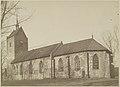
 Exterieur - Anloo - 20022706 - RCE.jpg 1,200 × 803; 310 KB
-
 Exterieur naar het noord-westen - Anloo - 20022675 - RCE.jpg 1,200 × 888; 253 KB
-
 Exterieur noord-zijde - Anloo - 20022711 - RCE.jpg 1,200 × 812; 251 KB
-
 Exterieur overzicht naar het noord-westen - Anloo - 20022671 - RCE.jpg 1,200 × 955; 417 KB
-
 Exterieur overzicht zuidoostgevel, koor - Anloo - 20322655 - RCE.jpg 1,200 × 935; 314 KB
-
 Exterieur OVERZICHT, ZUIDGEVEL, OOSTGEVEL - Anloo - 20259951 - RCE.jpg 1,190 × 1,200; 227 KB
-
 Exterieur tekening - Anloo - 20022708 - RCE.jpg 1,200 × 1,002; 192 KB
-
 Exterieur vanuit het zuiden - Anloo - 20022672 - RCE.jpg 1,200 × 900; 256 KB
-
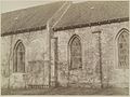
 Exterieur zuid-zijde - Anloo - 20022673 - RCE.jpg 1,200 × 840; 238 KB
-
 Exterieur zuid-zijde - Anloo - 20022712 - RCE.jpg 1,200 × 807; 258 KB
-
 Exterieur ZUIDGEVEL - Anloo - 20259950 - RCE.jpg 986 × 1,200; 277 KB
-
 Gevonden gebeeldhouwde stenen - Anloo - 20022700 - RCE.jpg 1,200 × 1,200; 352 KB
-
 Gevonden gebeeldhouwde stenen - Anloo - 20022701 - RCE.jpg 1,200 × 1,166; 377 KB
-
 Gevonden gebeeldhouwde stenen - Anloo - 20022702 - RCE.jpg 1,200 × 1,192; 353 KB
-
 Gevonden gebeeldhouwde stenen - Anloo - 20022703 - RCE.jpg 1,192 × 1,200; 305 KB
-
 Herenbank - Anloo - 20022722 - RCE.jpg 960 × 1,200; 242 KB
-
 Herenbank onder het orgel - Anloo - 20022723 - RCE.jpg 1,197 × 1,200; 243 KB
-

-

-

-

-

-
 Interieur hervormde kerk- muurschildering in nis - Anloo - 20319498 - RCE.jpg 888 × 1,200; 214 KB
-

-

-

-
 Interieur koor - Anloo - 20022718 - RCE.jpg 960 × 1,200; 322 KB
-
 Interieur koor naar het westen en naar het oosten - Anloo - 20022685 - RCE.jpg 831 × 1,200; 200 KB
-
 Interieur koor naar het westen en naar het oosten - Anloo - 20022686 - RCE.jpg 845 × 1,200; 189 KB
-
 Interieur naar het koor - Anloo - 20022716 - RCE.jpg 1,200 × 960; 218 KB
-
 Interieur naar het koor - Anloo - 20022717 - RCE.jpg 1,200 × 960; 214 KB
-
 Interieur naar het westen - Anloo - 20022715 - RCE.jpg 1,200 × 953; 212 KB
-

-

-

-
 Interieur, meubilair - Anloo - 20411365 - RCE.jpg 1,200 × 907; 93 KB
-
 Inwendig naar het oosten - Anloo - 20022687 - RCE.jpg 1,200 × 878; 235 KB
-
 Inwendig schip - Anloo - 20022681 - RCE.jpg 840 × 1,200; 127 KB
-
 Inwendig schip - Anloo - 20022682 - RCE.jpg 826 × 1,200; 129 KB
-
 Inwendig schip naar het westen - Anloo - 20022683 - RCE.jpg 815 × 1,200; 140 KB
-
 Inwendig schip naar het westen - Anloo - 20022684 - RCE.jpg 826 × 1,200; 160 KB
-
 Kandelaar - Anloo - 20022725 - RCE.jpg 1,200 × 1,190; 195 KB
-
 Kerk Anloo.jpg 3,072 × 2,304; 1.39 MB
-

-
 Kerk en terrein vanuit het zuid-oosten - Anloo - 20022705 - RCE.jpg 1,200 × 797; 217 KB
-
 Kroonlamp - Anloo - 20022724 - RCE.jpg 1,200 × 1,195; 185 KB
-
 Muurschildering - Anloo - 20022694 - RCE.jpg 897 × 1,200; 274 KB
-
 Muurschildering - Anloo - 20022695 - RCE.jpg 885 × 1,200; 315 KB
-
 Muurschildering - Anloo - 20022696 - RCE.jpg 885 × 1,200; 190 KB
-
 Muurschildering - Anloo - 20022697 - RCE.jpg 1,200 × 894; 298 KB
-
 Muurschildering - Anloo - 20022698 - RCE.jpg 1,200 × 884; 301 KB
-
 Muurschildering N.O.zijde - Anloo - 20022730 - RCE.jpg 1,200 × 1,197; 268 KB
-
 Muurschildering noordmuur - Anloo - 20022729 - RCE.jpg 1,200 × 1,195; 298 KB
-
 Muurschildering oostmuur - Anloo - 20022732 - RCE.jpg 1,200 × 1,195; 275 KB
-
 Muurschildering oostmuur - Anloo - 20022733 - RCE.jpg 1,200 × 1,183; 278 KB
-
 Muurschildering oostzijde - Anloo - 20022728 - RCE.jpg 960 × 1,200; 265 KB
-
 Muurschildering triomfboog oostmuur - Anloo - 20022731 - RCE.jpg 1,200 × 1,195; 308 KB
-
 Noordgevel, detail ingemetselde grafzerk - Anloo - 20371112 - RCE.jpg 779 × 1,200; 329 KB
-
 Offerblok - Anloo - 20022727 - RCE.jpg 1,200 × 1,200; 308 KB
-
 Overzicht - Anloo - 20022760 - RCE.jpg 1,200 × 811; 333 KB
-
 Overzicht hervormde kerk vanuit het zuiden - Anloo - 20319474 - RCE.jpg 1,200 × 875; 267 KB
-
 Overzicht hervormde kerk zuidzijde - Anloo - 20319471 - RCE.jpg 3,597 × 2,613; 2.29 MB
-

-
 Overzicht noordzijde - Anloo - 20529365 - RCE.jpg 1,200 × 800; 220 KB
-
 Overzicht toren hervormde kerk westzijde - Anloo - 20319473 - RCE.jpg 883 × 1,200; 250 KB
-

-
 Plattegrond - Anloo - 20022710 - RCE.jpg 872 × 1,200; 242 KB
-
 Preekstoel - Anloo - 20022719 - RCE.jpg 960 × 1,200; 259 KB
-

-

-

-
 Schetsblad H.Dryden 1878 - Anloo - 20022667 - RCE.jpg 892 × 1,200; 131 KB
-
 Schip en koor zuid-zijde - Anloo - 20022679 - RCE.jpg 1,200 × 873; 380 KB
-
 Schip en koor. noord-zijde - Anloo - 20022680 - RCE.jpg 1,200 × 900; 357 KB
-
 Sint-Magnuskerk, Anloo, Drenthe, Netherlands - panoramio.jpg 1,200 × 1,600; 625 KB
-
 Tekstschildering oostmuur - Anloo - 20022734 - RCE.jpg 1,200 × 1,195; 374 KB
-
 Toren - Anloo - 20022707 - RCE.jpg 812 × 1,200; 209 KB
-
 Toren en Schip, noord-zijde - Anloo - 20022678 - RCE.jpg 904 × 1,200; 310 KB
-
 Toren en schip, zuid-zijde - Anloo - 20022677 - RCE.jpg 893 × 1,200; 308 KB
-

-
 Venster in 12e eeuwse toren - Anloo - 20529361 - RCE.jpg 800 × 1,200; 353 KB
-
 Venster in 12e eeuwse toren - Anloo - 20529362 - RCE.jpg 1,200 × 799; 322 KB
-
 Venster in 12e eeuwse toren - Anloo - 20529425 - RCE.jpg 1,200 × 800; 373 KB
-
 Venster in het schip, gezien vanaf de buitenkant - Anloo - 20529360 - RCE.jpg 800 × 1,200; 192 KB
-
 Wandschildering - Anloo - 20022688 - RCE.jpg 906 × 1,200; 287 KB
-
 Wandschildering - Anloo - 20022689 - RCE.jpg 910 × 1,200; 254 KB
-
 Wandschildering - Anloo - 20022690 - RCE.jpg 919 × 1,200; 286 KB
-
 Wandschildering - Anloo - 20022691 - RCE.jpg 1,200 × 920; 275 KB
-
 Wandschildering - Anloo - 20022692 - RCE.jpg 907 × 1,200; 231 KB
-
 Wandschildering - Anloo - 20022693 - RCE.jpg 914 × 1,200; 217 KB
-
 Westgevel toren - Anloo - 20022676 - RCE.jpg 833 × 1,200; 305 KB
-
 Zadeldaktoren van de Magnuskerk van Anloo.jpg 1,722 × 2,454; 350 KB
-
 Zandloperhouder - Anloo - 20022726 - RCE.jpg 1,200 × 1,200; 157 KB
-
 Zandstenen plaat gevonden in Kerk 4 april 1941 - Anloo - 20022709 - RCE.jpg 1,200 × 600; 147 KB
-
 Zicht op de koorzijde - Anloo - 20529359 - RCE.jpg 1,200 × 799; 266 KB
-
 Zicht op de noordzijde - Anloo - 20529431 - RCE.jpg 800 × 1,200; 224 KB
-
 Zicht op de zuidgevel van het schip - Anloo - 20529426 - RCE.jpg 1,200 × 800; 276 KB
-
 Zicht op de zuidgevel van het schip, detail - Anloo - 20529427 - RCE.jpg 800 × 1,200; 291 KB
-
 Zicht op deel noordzijde hervormde kerk - Anloo - 20319504 - RCE.jpg 1,200 × 915; 253 KB
-

-
-

-
 Zicht op hervormde kerk vanuit het zuidwesten - Anloo - 20319402 - RCE.jpg 835 × 1,200; 277 KB
-

-
 Zicht op onderzijde toren- gefundeerd op zwerfkeien - Anloo - 20529428 - RCE.jpg 1,200 × 800; 282 KB
-

-
 Zijgevel nr. F 129-20 - Anlo - 20492976 - RCE.jpg 1,200 × 900; 123 KB
-
 Zuid-oost zijde - Anloo - 20022714 - RCE.jpg 1,200 × 807; 335 KB
-
 Zuid-zijde van af Gasterenseweg - Anloo - 20022713 - RCE.jpg 1,200 × 813; 287 KB
-

-


