Category:NYPL maps of Brooklyn
Jump to navigation
Jump to search
Subcategories
This category has the following 9 subcategories, out of 9 total.
B
H
Media in category "NYPL maps of Brooklyn"
The following 67 files are in this category, out of 67 total.
-
 Bayridge. Town of New Utrecht, Kings Co. NYPL1527267.tiff 7,230 × 5,428; 112.31 MB
-
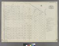
 Brooklyn V. 9, Plate No. 13 (Map bounded by cemetery of the Evergreen, Oonway St., Broadway, Aberdeen St.) NYPL1810733.tiff 5,412 × 7,216, 2 pages; 111.79 MB
-
 Canarsie. Town of Flat Lands, Kings Co. NYPL1527274.tiff 5,428 × 7,230; 112.31 MB
-
-

-
-

-

-

-
-

-

-

-
-

-

-

-

-

-

-

-

-

-

-

-

-

-

-
-

-

-

-

-
-
-

-

-

-

-
-
-

-

-

-
-

-
-

-

-

-

-

-

-

-
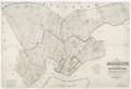
 Flatbush. Town of Flatabush, Kings Co. L.I. - Prospect Park. NYPL1527266.tiff 10,470 × 7,065; 211.66 MB
-
 Flatlands. Kings Co. L.I. NYPL1527273.tiff 5,428 × 7,230; 112.31 MB
-
 Fort Hamilton. Town of New Utrecht, Kings Co. L.I. NYPL1527268.tiff 5,428 × 7,230; 112.31 MB
-
 Green-wood cemetery - James Smillie; William Lawrence. NYPL434096.tiff 1,739 × 2,248; 11.21 MB
-
 Green-Wood Cemetery map in 1899 - from, Double Page Plate No. 11 - NYPL1517521 (cropped).tiff 3,348 × 2,255; 21.62 MB
-
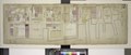
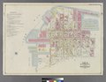
 Map of the Borough of Brooklyn Published for the Brooklyn Directory. NYPL2012543.tiff 7,760 × 9,980, 2 pages; 221.84 MB
-
-
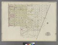
 New Lots. Kings Co. L.I. NYPL1527276.tiff 5,428 × 7,230; 112.31 MB
-
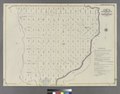
 New Utrecht. Kings Co. - Bath, Town on New Utrecht, Kings Co. NYPL1527265.tiff 5,428 × 7,230; 112.31 MB
-

-

-
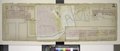
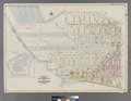
 The City of Brooklyn. NYPL1527263.tiff 10,470 × 7,098; 212.65 MB
-
