Category:NARA images of Wyoming
Jump to navigation
Jump to search
States of the United States: Alabama · Alaska · Arizona · Arkansas · California · Colorado · Connecticut · Delaware · Florida · Georgia · Hawaii · Idaho · Illinois · Indiana · Iowa · Kansas · Kentucky · Louisiana · Maine · Maryland · Massachusetts · Michigan · Minnesota · Mississippi · Missouri · Montana · Nebraska · Nevada · New Hampshire · New Jersey · New Mexico · New York · North Carolina · North Dakota · Ohio · Oklahoma · Oregon · Pennsylvania · Rhode Island · South Carolina · South Dakota · Tennessee · Texas · Utah · Vermont · Virginia · Washington · West Virginia · Wisconsin · Wyoming – Washington, D.C.
American Samoa · Guam · Northern Mariana Islands · Puerto Rico · United States Virgin Islands
American Samoa · Guam · Northern Mariana Islands · Puerto Rico · United States Virgin Islands
English: Images from NARA—the National Archives and Records Administration — of Wyoming.
- Images from the 19th and 20th centuries.
Subcategories
This category has the following 7 subcategories, out of 7 total.
Media in category "NARA images of Wyoming"
The following 172 files are in this category, out of 172 total.
-
 "Bridge construction near Jackson, Wyoming" - NARA - 292828.jpg 3,000 × 1,806; 2.31 MB
-
 "Bridge on highway near Wind River Indian Reservation." - NARA - 292842.jpg 3,000 × 1,738; 2.91 MB
-
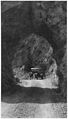 "Tunnel on highway along Wind River in Wyoming." - NARA - 292841.jpg 1,713 × 3,000; 2.43 MB
-
 "Workers in camp on Wyoming road project." - NARA - 292838.jpg 3,000 × 1,734; 2.82 MB
-
 Photograph of the Red Buttes - NARA - 516886.jpg 3,000 × 2,283; 1.44 MB
-
 ABANDONED BUILDING - NARA - 549221.jpg 3,000 × 2,029; 653 KB
-
 ACME COAL MINE - NARA - 549245.jpg 3,000 × 2,027; 960 KB
-
 Adams The Tetons and the Snake River.jpg 3,000 × 2,402; 1.78 MB
-
 Administrative Structures - Wyoming - DPLA - 0f1b0c98bb3b419df0f4ed41deb4858c.jpg 4,964 × 3,971; 3.37 MB
-
 Administrative Structures - Wyoming - DPLA - 43116de782e7cd9d0654f3d0aaf633ad.jpg 3,750 × 2,925; 1.58 MB
-
 Administrative Structures - Wyoming - DPLA - cc831d2ffebab269027711fe7713bf33.jpg 5,032 × 3,949; 2.09 MB
-
 Administrative Structures - Wyoming - DPLA - ee2549aa7392e7f86bfbc4b86e96738d.jpg 4,912 × 3,859; 1.64 MB
-
 Ansel Adams - National Archives 79-AA-G07.jpg 3,000 × 2,319; 913 KB
-
 Ansel Adams - National Archives 79-AA-T01.jpg 2,309 × 3,000; 1.02 MB
-
 Ansel Adams - National Archives 79-AA-T02.jpg 3,000 × 2,415; 600 KB
-
 Ansel Adams - National Archives 79-AA-T03.jpg 2,050 × 3,000; 862 KB
-
 Ansel Adams - National Archives 79-AA-T06.jpg 3,000 × 2,365; 465 KB
-
 Ansel Adams - National Archives 79-AA-T07.jpg 3,000 × 2,385; 1.05 MB
-
 Ansel Adams - National Archives 79-AA-T08.jpg 3,000 × 2,341; 927 KB
-
 Ansel Adams - National Archives 79-AA-T09.jpg 2,202 × 3,000; 375 KB
-
 Ansel Adams - National Archives 79-AA-T10.jpg 3,000 × 2,423; 937 KB
-
 Ansel Adams - National Archives 79-AA-T11.jpg 3,000 × 2,097; 449 KB
-
 Ansel Adams - National Archives 79-AA-T12.jpg 3,000 × 2,387; 1.18 MB
-
 Ansel Adams - National Archives 79-AA-T14.jpg 3,000 × 2,134; 811 KB
-
 Ansel Adams - National Archives 79-AA-T15.jpg 3,000 × 2,124; 890 KB
-
 Ansel Adams - National Archives 79-AA-T16.jpg 3,000 × 2,144; 987 KB
-
 Ansel Adams - National Archives 79-AA-T17.jpg 3,000 × 2,134; 600 KB
-
 Ansel Adams - National Archives 79-AA-T18.jpg 3,000 × 2,134; 614 KB
-
 Ansel Adams - National Archives 79-AA-T19.jpg 3,000 × 2,177; 641 KB
-
 Ansel Adams - National Archives 79-AA-T20.jpg 3,000 × 2,053; 1.01 MB
-
 Ansel Adams - National Archives 79-AA-T21.jpg 2,137 × 3,000; 301 KB
-
 Ansel Adams - National Archives 79-AA-T22.jpg 2,145 × 3,000; 344 KB
-
 Ansel Adams - National Archives 79-AA-T23.jpg 2,147 × 3,000; 347 KB
-
 Ansel Adams - National Archives 79-AA-T24.jpg 2,157 × 3,000; 404 KB
-
 Ansel Adams - National Archives 79-AA-T25.jpg 2,073 × 3,000; 409 KB
-
 Ansel Adams - National Archives 79-AA-T26.jpg 2,126 × 3,000; 416 KB
-
 Ansel Adams - National Archives 79-AA-T27.jpg 2,132 × 3,000; 445 KB
-
 ANTELOPE GRAZE NEAR THE DAVE JOHNSTON POWER PLANT - NARA - 549219.jpg 3,000 × 2,021; 556 KB
-
 Bad Lands on Wind River. Fremont County, Wyoming - NARA - 517201.jpg 3,000 × 1,816; 1.33 MB
-
 Beaver Dam Gulch. Wyoming - NARA - 516912.jpg 3,000 × 2,155; 1.37 MB
-
 BILLBOARD - NARA - 549223.jpg 3,000 × 1,994; 574 KB
-
 Bad Lands on Black's Fork, Uinta County, Wyoming - NARA - 516915.jpg 3,000 × 2,485; 1.81 MB
-
 Bad Lands on Black's Fork, Uinta County, Wyoming - NARA - 516916.jpg 3,000 × 2,183; 994 KB
-
 Bad Lands on Black's Fork, Uinta County, Wyoming - NARA - 516917.jpg 3,000 × 2,199; 1,001 KB
-
 Butte, near Green River City, Wyoming - NARA - 519541.jpg 3,000 × 1,904; 1.72 MB
-

-
 Camp at Flaming Gorge, Green River, Wyoming - NARA - 519562.jpg 3,000 × 1,920; 1.34 MB
-
 CASPER-WYOMING'S LEADING INDUSTRIAL CITY - NARA - 549224.jpg 3,000 × 2,016; 556 KB
-
 Castellated rocks on the Chugwater, Wyoming - NARA - 516860.jpg 3,000 × 2,294; 1.22 MB
-
 Castellated rocks on the Chugwater, Wyoming - NARA - 516861.jpg 3,000 × 2,307; 1.71 MB
-
 CATTLE GRAZE ON RANCH LANDS NEAR THE DAVE JOHNSTON POWER PLANT - NARA - 549214.jpg 3,000 × 2,025; 612 KB
-
 Cheyenne. Laramie County, Wyoming - NARA - 517293.jpg 3,000 × 1,751; 1.24 MB
-
 Church Buttes on Black's Fork. Uinta County, Wyoming - NARA - 517410.jpg 3,000 × 1,735; 1.13 MB
-
 Church Buttes. Wyoming - NARA - 517067.jpg 3,000 × 1,955; 1.73 MB
-

-
 Evanston coal mines. Uinta County, Wyoming - NARA - 516736.jpg 3,000 × 2,452; 1.34 MB
-

-

-

-
 Dale Creek bridge, West Cheyenne. Albany County, Wyoming - NARA - 516613.jpg 3,000 × 2,349; 1.03 MB
-
 Dale Creek Bridge, west of Cheyenne, Wyoming - NARA - 517377.jpg 3,000 × 1,478; 1.14 MB
-
 Dale Creek Bridge. Albany County, Wyoming - NARA - 517374.jpg 3,000 × 1,405; 1.08 MB
-
 Damage and Loss to Tree Stands - Wyoming - DPLA - 330baf646be1a1fc8bf6dddb8082244a.jpg 4,887 × 4,020; 3.21 MB
-
 Effects of Grazing - Wyoming - DPLA - e4f752c90e89187a60b3e567e92d284d.jpg 4,842 × 3,840; 1.57 MB
-
 Erosion Effects - Wyoming - DPLA - 5666e5ba53661431b409f212d9762363.jpg 4,789 × 3,888; 2.62 MB
-
 FARM IRRIGATION - NARA - 549178.jpg 3,000 × 2,046; 539 KB
-
 Fire Control- Lookouts - Wyoming - DPLA - 80862b5a86b17988d8aad9b7d2985b7f.jpg 4,745 × 3,867; 2.59 MB
-
 Flaming Gorge on Green River, Wyoming - NARA - 519563.jpg 3,000 × 1,914; 1.53 MB
-
 Flaming Gorge. Green River, Wyoming - NARA - 519464.jpg 3,000 × 2,510; 1.6 MB
-
 Flaming Gorge. Green River, Wyoming - NARA - 519465.jpg 3,000 × 2,504; 2.1 MB
-
 Flaming Gorge. Green River, Wyoming - NARA - 519466.jpg 3,000 × 2,499; 1.68 MB
-
 Flaming Gorge. Green River, Wyoming - NARA - 519467.jpg 2,499 × 3,000; 1.7 MB
-

-
 Ansel Adams - National Archives 79-AA-G02.jpg 3,000 × 2,401; 776 KB
-
 Ansel Adams - National Archives 79-AA-G03.jpg 2,369 × 3,000; 1,012 KB
-
 Ansel Adams - National Archives 79-AA-G04.jpg 3,000 × 2,398; 1.15 MB
-
 Ansel Adams - National Archives 79-AA-G06.jpg 3,000 × 2,743; 956 KB
-
 Ansel Adams - National Archives 79-AA-G09.jpg 3,000 × 2,277; 739 KB
-
 Ansel Adams - National Archives 79-AA-G10.jpg 3,000 × 2,364; 484 KB
-
 Ansel Adams - National Archives 79-AA-G11.jpg 3,000 × 2,221; 1.04 MB
-
 Grand Teton. Lincoln County, Wyoming - NARA - 516771.jpg 2,349 × 3,000; 1.7 MB
-
 Great Teton. Lincoln County, Wyoming - NARA - 517291.jpg 3,000 × 1,900; 1.38 MB
-
 Tetons from the east. Wyoming - NARA - 517662.jpg 3,000 × 2,250; 1.73 MB
-
 The Teton Range, western Wyoming - NARA - 517658.jpg 3,000 × 2,299; 1.36 MB
-
 Green River bridge and butte. Sweetwater County, Wyoming - NARA - 516617.jpg 3,000 × 2,329; 1.02 MB
-
 Green River Butte and bridge. Sweetwater County, Wyoming - NARA - 517366.jpg 3,000 × 1,592; 1.07 MB
-

-
 Heart Mountain Boy Scout Flag Raising retouched 2.jpg 553 × 582; 74 KB
-

-

-
-
-
 Horseshoe Canyon, Green River, Wyoming - NARA - 519565.jpg 3,000 × 1,912; 1.39 MB
-
 Independence Rock, Wyoming - DPLA - 9e70d5ba285c095354bdc2411c6ca907.jpg 6,796 × 4,955; 8.33 MB
-
-

-
 Lake Scenes - Wyoming - DPLA - 10e0e2b40a6f332b2966aa710d67c23c.jpg 4,775 × 3,755; 1.47 MB
-
 Lake Scenes - Wyoming - DPLA - 9e6e18312a1f8d6b51011ad496aae392.jpg 4,751 × 3,797; 2.46 MB
-
 Lake Scenes - Wyoming - DPLA - d43bb9c7f144d7442880e99cc8d75973.jpg 4,769 × 3,802; 2.28 MB
-
 Logging- Transportation- Log Drive - Wyoming - DPLA - b43a80e4efc1f425541aa356b9e21dc5.jpg 3,676 × 2,915; 1.23 MB
-

-
 Mauvaises Terres. Washakie Badlands, Wyoming - NARA - 519463.jpg 2,527 × 3,000; 1.64 MB
-
 Methods and Technologies - All States - DPLA - 1d2943ba214899aee616d9d611985578.jpg 4,842 × 3,865; 2.96 MB
-

-
 OIL WELLS NEAR TEAPOT DOME, WYOMING - NARA - 549207.jpg 2,019 × 3,000; 847 KB
-
 OIL WELLS NEAR TEAPOT DOME, WYOMING - NARA - 549207.tif 2,019 × 3,000; 17.33 MB
-
 OIL WELLS NEAR TEAPOT DOME, WYOMING - NARA - 549208.jpg 3,000 × 2,024; 611 KB
-
 OIL WELLS NEAR TEAPOT DOME, WYOMING - NARA - 549208.tif 3,000 × 2,024; 17.37 MB
-
 OIL WELLS NEAR TEAPOT DOME, WYOMING - NARA - 549209.jpg 2,036 × 3,000; 807 KB
-
 OIL WELLS NEAR TEAPOT DOME, WYOMING - NARA - 549209.tif 2,036 × 3,000; 17.48 MB
-

-
 Railroad roundhouse. Laramie County, Wyoming - NARA - 517277.jpg 3,000 × 1,797; 994 KB
-
 Railroad roundhouse. Laramie County, Wyoming - NARA - 517277.tif 3,000 × 1,797; 5.14 MB
-
 RANCH IN THE POWDER RIVER BASIN - NARA - 549222.jpg 3,000 × 2,029; 464 KB
-
 River Scenes - Wyoming - DPLA - 1eabc3ae0fc605771fbbd0873821ad78.jpg 4,775 × 3,773; 2.61 MB
-
 River Scenes - Wyoming - DPLA - 6c8f1736388e1b1d16c1753dd227c578.jpg 4,751 × 3,821; 2.64 MB
-
 River Scenes - Wyoming - DPLA - e9c23329b1b431de91cfedb6fdff0ffb.jpg 4,781 × 3,809; 2.5 MB
-

-
 Source of the Popo Agie, Wind River Mountains. Fremont County, Wyoming. - NARA - 516960.jpg 3,000 × 1,793; 1.02 MB
-
 South Pass. Fremont County, Wyoming - NARA - 516910.jpg 3,000 × 2,402; 998 KB
-
 South Pass. Fremont County, Wyoming - NARA - 516910.tif 3,000 × 2,402; 6.87 MB
-
 Studies on the left fork of Teton River. Lincoln County, Wyoming. - NARA - 517458.jpg 3,000 × 1,944; 1.99 MB
-
 Studies on the left fork of Teton River. Lincoln County, Wyoming. - NARA - 517459.jpg 3,000 × 1,933; 2.17 MB
-
 Studies on the right fork of Teton River. Lincoln County, Wyoming. - NARA - 517460.jpg 3,000 × 1,910; 1.39 MB
-
 Studies on the right fork of Teton River. Lincoln County, Wyoming. - NARA - 517461.jpg 3,000 × 1,790; 1.77 MB
-
 Tertiary Bluffs or Buttes. Near Green River City, Wyoming - NARA - 519443.jpg 3,000 × 2,493; 2.09 MB
-
 Tertiary Bluffs or Buttes. Near Green River City, Wyoming - NARA - 519443.tif 3,000 × 2,493; 7.13 MB
-
 Tertiary Bluffs or Buttes. Near Green River City, Wyoming - NARA - 519444.jpg 3,000 × 2,424; 1.87 MB
-
 Tertiary Bluffs or Buttes. Near Green River City, Wyoming - NARA - 519444.tif 3,000 × 2,424; 6.94 MB
-
 Tertiary Bluffs or Buttes. Near Green River City, Wyoming - NARA - 519445.jpg 3,000 × 2,431; 2.06 MB
-
 Tertiary Bluffs or Buttes. Near Green River City, Wyoming - NARA - 519445.tif 3,000 × 2,431; 6.96 MB
-
 Tertiary Bluffs or Buttes. Near Green River City, Wyoming - NARA - 519446.jpg 3,000 × 2,467; 1.6 MB
-
 Tertiary Bluffs or Buttes. Near Green River City, Wyoming - NARA - 519446.tif 3,000 × 2,467; 7.06 MB
-
 Tertiary Bluffs or Buttes. Near Green River City, Wyoming - NARA - 519447.jpg 3,000 × 2,500; 1.96 MB
-
 Tertiary Bluffs or Buttes. Near Green River City, Wyoming - NARA - 519447.tif 3,000 × 2,500; 7.15 MB
-
 Tertitary Bluffs or Buttes. Near Green River City, Wyoming - NARA - 519448.jpg 3,000 × 2,450; 1.66 MB
-
 Tertitary Bluffs or Buttes. Near Green River City, Wyoming - NARA - 519448.tif 3,000 × 2,450; 7.01 MB
-
 Tetons from the east. Wyoming - NARA - 517662.tif 3,000 × 2,250; 6.44 MB
-
 The Three Tetons, Wyoming - NARA - 517660.tif 3,000 × 2,336; 6.68 MB
-

-
-

-

-

-

-

-
 Togwotee Pass, Wyoming - NARA - 517199.jpg 3,000 × 1,817; 1.27 MB
-
 Togwotee Pass, Wyoming - NARA - 517199.tif 3,000 × 1,817; 5.2 MB
-
 Washakie Badlands, Wyoming - NARA - 519552.jpg 3,000 × 1,890; 1.25 MB
-
 Washakie Badlands, Wyoming - NARA - 519552.tif 3,000 × 1,890; 5.41 MB
-
 Washakie Badlands, Wyoming - NARA - 519554.jpg 3,000 × 1,806; 1.15 MB
-
 Washakie Badlands, Wyoming - NARA - 519554.tif 3,000 × 1,806; 5.17 MB
-
 Washakie Badlands, Wyoming - NARA - 519555.jpg 3,000 × 1,874; 1.15 MB
-
 Washakie Badlands, Wyoming - NARA - 519555.tif 3,000 × 1,874; 5.36 MB
-
 Washakie Badlands, Wyoming - NARA - 519556.jpg 3,000 × 1,832; 1.31 MB
-
 Washakie Badlands, Wyoming - NARA - 519556.tif 3,000 × 1,832; 5.24 MB
-
 Washakie Badlands, Wyoming - NARA - 519557.jpg 3,000 × 1,857; 1.24 MB
-
 Washakie Badlands, Wyoming - NARA - 519557.tif 3,000 × 1,857; 5.31 MB
-
 Washakie Badlands, Wyoming - NARA - 519558.jpg 3,000 × 1,865; 1.22 MB
-
 Washakie Badlands, Wyoming - NARA - 519558.tif 3,000 × 1,865; 5.34 MB
-
 Washakie Badlands, Wyoming - NARA - 519559.jpg 3,000 × 1,878; 1.11 MB
-
 Washakie Badlands, Wyoming - NARA - 519559.tif 3,000 × 1,878; 5.37 MB
-
 Washakie Badlands, Wyoming - NARA - 519560.jpg 3,000 × 1,854; 1.35 MB
-
 Washakie Badlands, Wyoming - NARA - 519560.tif 3,000 × 1,854; 5.3 MB
-

-
 Wind River Peak, Wyoming. A.D. Wilson in picture - NARA - 517694.jpg 3,000 × 2,279; 1.53 MB
-
 Wind River Peak. Fremont County, Wyoming - NARA - 517204.jpg 3,000 × 1,788; 1.4 MB
-
 WINDMILL AND POWER LINES NEAR THE DAVE JOHNSTON POWER PLANT - NARA - 549212.jpg 2,028 × 3,000; 520 KB
-
 WINDMILL AND POWER LINES NEAR THE DAVE JOHNSTON POWER PLANT - NARA - 549213.jpg 3,000 × 2,028; 610 KB
-
 WINDMILL IN THE RIVER ROLLING RANCH LANDS NEAR POWDER RIVER WYOMING - NARA - 549210.jpg 3,000 × 2,012; 619 KB
-

-
 WINDMILL ON THE ROLLING RANCH LANDS NEAR POWDER RIVER WYOMING - NARA - 549211.jpg 2,012 × 3,000; 597 KB


_present_a_hat_and_saber_to_Governor_Ed_Herschler_of_Wyoming,_as_Colonel_James_M._Cowan,_Strategic_M_-_DPLA_-_03124d90da14e6727f42d61d6180d64d.jpeg)


