Category:Mucklestone
Jump to navigation
Jump to search
English: Mucklestone is a small village in Staffordshire, England. It is about nine miles (14 km) northwest of Eccleshall, and four and a half miles northeast of Market Drayton in Shropshire.
Nederlands: Mucklestone is een plaats in het bestuurlijke gebied Newcastle-under-Lyme, in het Engelse graafschap Staffordshire.
village in Staffordshire, United Kingdom  | |||||
| Upload media | |||||
| Instance of |
| ||||
|---|---|---|---|---|---|
| Location | Loggerheads, Newcastle-under-Lyme, Staffordshire, West Midlands, England | ||||
 | |||||
Subcategories
This category has the following 2 subcategories, out of 2 total.
B
- Battle of Blore Heath (7 F)
M
Media in category "Mucklestone"
The following 27 files are in this category, out of 27 total.
-
 Battle of Blore Heath - geograph.org.uk - 566451.jpg 640 × 480; 72 KB
-
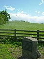
 Blore Heath Plaque - geograph.org.uk - 8184.jpg 640 × 480; 152 KB
-
 Devils Ring And Fingure - geograph.org.uk - 227107.jpg 640 × 480; 174 KB
-
 Drive to Eccleshall Road Farm - geograph.org.uk - 522593.jpg 640 × 480; 88 KB
-
 Farmland beside the B5415 - geograph.org.uk - 552765.jpg 640 × 480; 97 KB
-
 Hales, Flash Lane - geograph.org.uk - 470400.jpg 640 × 480; 111 KB
-
 Loggerheads - geograph.org.uk - 275952.jpg 640 × 427; 52 KB
-
 Milepost at NGR SJ 7258 3738.jpg 492 × 701; 66 KB
-
 Mucklestone - geograph.org.uk - 469863.jpg 640 × 480; 93 KB
-
 Mucklestone Anvil.jpg 1,024 × 577; 218 KB
-
 Old Pool Plantation - geograph.org.uk - 582074.jpg 640 × 480; 111 KB
-
 Bearstone Mill - geograph.org.uk - 3879.jpg 640 × 480; 80 KB
-
 Blore - geograph.org.uk - 469886.jpg 640 × 421; 105 KB
-
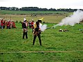
 Blore Heath Battle re-enactment - geograph.org.uk - 566446.jpg 640 × 480; 47 KB
-
 Blore Heath Battleground - geograph.org.uk - 8182.jpg 480 × 640; 99 KB
-
 Bloreheath - geograph.org.uk - 469889.jpg 640 × 480; 109 KB
-
 Entrance to fields off B5415 - geograph.org.uk - 552728.jpg 640 × 480; 81 KB
-
 Farm Buildings - geograph.org.uk - 531296.jpg 640 × 480; 89 KB
-
 Farm Buildings, Bearstone - geograph.org.uk - 2362.jpg 640 × 480; 63 KB
-
 Junction of B5415 and B5026 - geograph.org.uk - 531260.jpg 640 × 480; 88 KB
-
 Loggerheads Crossroads - geograph.org.uk - 1248.jpg 640 × 480; 35 KB
-
 Loggerheads, Brookfield - geograph.org.uk - 469859.jpg 640 × 480; 82 KB
-
 Loggerheads, Chestnut Road - geograph.org.uk - 469851.jpg 640 × 480; 109 KB
-
 Oakley Folly - geograph.org.uk - 3875.jpg 640 × 480; 74 KB
-
 Old Farm Cottages - geograph.org.uk - 5225.jpg 640 × 480; 51 KB
-
 Sleepy Lane - geograph.org.uk - 5224.jpg 640 × 480; 92 KB
-
 Stile beside the B5415 - geograph.org.uk - 582078.jpg 640 × 480; 121 KB


