Category:Mr O'Toole's, Regent Road, Liverpool
Jump to navigation
Jump to search
| Object location | | View all coordinates using: OpenStreetMap |
|---|
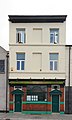
Formerly The Farmer's Arms pub, recently a bed & breakfast hotel, and currently a wine bar.
Media in category "Mr O'Toole's, Regent Road, Liverpool"
The following 2 files are in this category, out of 2 total.
-
 Mr O'Toole's, Regent Road.jpg 2,751 × 4,593; 6.93 MB
-
 Mr O'Tooles, Liverpool.jpg 3,240 × 4,320; 2.48 MB

