Category:Mouswald (civil parish)
Jump to navigation
Jump to search
Scottish parish in Dumfries and Galloway, Scotland, UK | |||||
| Upload media | |||||
| Instance of | |||||
|---|---|---|---|---|---|
| Part of |
| ||||
| Named after | |||||
| Location |
| ||||
| Population |
| ||||
| Area |
| ||||
 | |||||
Media in category "Mouswald (civil parish)"
The following 177 files are in this category, out of 177 total.
-
 A wise old tree trunk at Mouswald - geograph.org.uk - 2269782.jpg 640 × 481; 98 KB
-
 A75 approaching Breconrae - geograph.org.uk - 3477171.jpg 640 × 448; 72 KB
-
 A75 at Beckness - geograph.org.uk - 2887596.jpg 640 × 480; 64 KB
-
 A75 at Beckness - geograph.org.uk - 2887598.jpg 640 × 480; 50 KB
-
 A75 at Breconrae - geograph.org.uk - 2887208.jpg 640 × 480; 111 KB
-
 A75 at Breconrae - geograph.org.uk - 3477176.jpg 640 × 462; 90 KB
-
 A75 at Woodside - geograph.org.uk - 3477167.jpg 640 × 355; 52 KB
-
 A75 near Cleughbrae - geograph.org.uk - 4587263.jpg 640 × 481; 71 KB
-
 A75 nearing Breconrae - geograph.org.uk - 4529253.jpg 640 × 481; 49 KB
-
 A75 westbound at Byeloch - geograph.org.uk - 4529250.jpg 640 × 479; 42 KB
-
 A75 westbound at Cleughbrae - geograph.org.uk - 4529251.jpg 640 × 480; 62 KB
-
 A75 westbound crosses Shaw Burn - geograph.org.uk - 4529255.jpg 640 × 479; 79 KB
-
 A75, Breconrae - geograph.org.uk - 3369677.jpg 640 × 480; 484 KB
-
 A75, West Raffles - geograph.org.uk - 3369738.jpg 640 × 480; 398 KB
-
 A75, Woodside - geograph.org.uk - 3369670.jpg 640 × 480; 491 KB
-
 Antennae station near Holmhead, Mouswald - geograph.org.uk - 1862144.jpg 1,200 × 1,600; 578 KB
-
 Approaching a turning to Dalton - geograph.org.uk - 3226971.jpg 2,134 × 1,424; 579 KB
-

-
 Approaching the start of a dual carriageway - geograph.org.uk - 3227001.jpg 2,077 × 1,535; 517 KB
-
 Approaching the turning to Dalton - geograph.org.uk - 3226001.jpg 2,273 × 1,437; 508 KB
-
 Approaching the turning to Dalton and Mouswald - geograph.org.uk - 3226962.jpg 2,012 × 1,331; 497 KB
-
 Approaching the turning to Mouswald - geograph.org.uk - 3226954.jpg 1,974 × 1,427; 350 KB
-
 B724 westwards approaching Wath - geograph.org.uk - 2949046.jpg 640 × 445; 83 KB
-
 Beware Cattle^ - geograph.org.uk - 3226961.jpg 2,225 × 1,414; 471 KB
-
 Boggy rough pasture on Lochar Moss near Dumfries - geograph.org.uk - 5749860.jpg 5,184 × 3,888; 6.69 MB
-
 Bogland-grassland by Mouswald Burn, Dumfries - geograph.org.uk - 5750006.jpg 3,128 × 2,346; 2.91 MB
-
 Breconrae - geograph.org.uk - 2887217.jpg 640 × 471; 77 KB
-
 Breconrae - geograph.org.uk - 3369681.jpg 640 × 480; 546 KB
-
 Breconrae junction with A75 - geograph.org.uk - 3991192.jpg 640 × 403; 55 KB
-
 Bridge across Black Grain burn - geograph.org.uk - 1862116.jpg 1,600 × 1,200; 796 KB
-
 Cairn on Rockhall Moor - geograph.org.uk - 1322582.jpg 640 × 480; 106 KB
-
 Cemetery Gates - geograph.org.uk - 4236444.jpg 640 × 462; 45 KB
-
 Chalets at Mouswald Caravan Park - geograph.org.uk - 2269775.jpg 640 × 481; 90 KB
-
 Cleughbrae - geograph.org.uk - 6220253.jpg 2,248 × 1,369; 473 KB
-
 Cleughbrae and the turning to Dalton - geograph.org.uk - 3226966.jpg 2,015 × 1,411; 589 KB
-
 Cottage beside the railway - geograph.org.uk - 4899228.jpg 2,864 × 1,752; 1.67 MB
-
 Cow Field near Mouswald - geograph.org.uk - 6220214.jpg 2,592 × 1,944; 1.68 MB
-
 Crossing Wath Burn - geograph.org.uk - 4362404.jpg 640 × 386; 96 KB
-
 Drainage ditch - geograph.org.uk - 4900372.jpg 1,990 × 2,759; 2.01 MB
-
 Drainage ditch - geograph.org.uk - 4900391.jpg 3,504 × 2,336; 4 MB
-
 Driving into Mouswald from the west - geograph.org.uk - 2269781.jpg 640 × 481; 52 KB
-
 Dwellings at Breconrae - geograph.org.uk - 2887179.jpg 640 × 480; 140 KB
-
 East Raffles - geograph.org.uk - 2887635.jpg 640 × 480; 56 KB
-
 Eastbound A75 - geograph.org.uk - 3369710.jpg 640 × 480; 474 KB
-
 Eastbound A75 - geograph.org.uk - 3369732.jpg 640 × 427; 364 KB
-
 Eastbound A75 approaching Cleughbrae - geograph.org.uk - 3369686.jpg 640 × 480; 528 KB
-

-
 Eastbound A75 near Byeloch - geograph.org.uk - 3369725.jpg 640 × 480; 451 KB
-
 Entrance to Mouswald Cemetery - geograph.org.uk - 4543573.jpg 5,184 × 3,456; 7.24 MB
-

-
 Farmland at Horseholm - geograph.org.uk - 1273320.jpg 640 × 480; 81 KB
-
 Farmland by the A75 - geograph.org.uk - 3537801.jpg 2,592 × 1,936; 1.49 MB
-
 Farmland by the A75 - geograph.org.uk - 6219409.jpg 2,592 × 1,944; 1.12 MB
-
 Farmland near Mouswald - geograph.org.uk - 5089563.jpg 800 × 600; 142 KB
-
 Field by Deadman's Gill - geograph.org.uk - 6220203.jpg 2,592 × 1,944; 1.35 MB
-
 Field by West Raffles - geograph.org.uk - 6220206.jpg 2,592 × 1,944; 1.51 MB
-
 Field near Racks Moss - geograph.org.uk - 4900384.jpg 3,504 × 2,336; 3.59 MB
-
 Forestry track through Holmhead Moss - geograph.org.uk - 1862138.jpg 1,600 × 1,200; 573 KB
-
 Gate and bridge at forestry road - geograph.org.uk - 1862120.jpg 1,600 × 1,200; 749 KB
-
 Gates to the cemetery at Mouswald - geograph.org.uk - 1870172.jpg 3,072 × 2,304; 1.02 MB
-
 HGV on the A75 - geograph.org.uk - 3369694.jpg 640 × 480; 508 KB
-
 High Plantation - geograph.org.uk - 2887582.jpg 480 × 640; 70 KB
-
 Holmains Moor - geograph.org.uk - 1322590.jpg 640 × 480; 110 KB
-
 Holmhead Moss forestry road - geograph.org.uk - 1862140.jpg 1,200 × 1,600; 552 KB
-
 Howthat Farm - geograph.org.uk - 4236424.jpg 640 × 480; 65 KB
-
 Ironhirst Moss - geograph.org.uk - 1862129.jpg 1,600 × 1,200; 913 KB
-
 Ironhirst Moss - geograph.org.uk - 1862133.jpg 1,600 × 1,200; 528 KB
-
 Ironhirst Moss - geograph.org.uk - 1862134.jpg 1,600 × 1,200; 530 KB
-
 Junction on A75 - geograph.org.uk - 4900463.jpg 3,504 × 2,336; 3.36 MB
-
 Langdyke farm buildings - geograph.org.uk - 1910236.jpg 1,024 × 768; 139 KB
-
 Long straight north of Mount Kedar - geograph.org.uk - 2949033.jpg 640 × 441; 69 KB
-
 Looking across the fields - geograph.org.uk - 4900331.jpg 3,504 × 2,336; 3.88 MB
-
 Looking downstream on Mouswald Burn near Dumfries - geograph.org.uk - 5749953.jpg 3,128 × 2,346; 2.65 MB
-
 Looking upstream on Mouswald Burn near Dumfries - geograph.org.uk - 5749944.jpg 3,128 × 2,346; 2.68 MB
-
 Low Plantation - geograph.org.uk - 2887586.jpg 640 × 480; 85 KB
-
 Metalled road - geograph.org.uk - 4900429.jpg 2,721 × 1,595; 1.41 MB
-
 Millholm Shaw - geograph.org.uk - 2887112.jpg 480 × 640; 50 KB
-
 Minor road north of Mouswald - geograph.org.uk - 4900458.jpg 3,504 × 2,336; 2.79 MB
-
 Minor Road to the A75 - geograph.org.uk - 4527491.jpg 1,920 × 1,280; 1.24 MB
-
 Minor Road to the B724 - geograph.org.uk - 4527489.jpg 1,920 × 1,280; 1.32 MB
-
 Mouswald Burn - geograph.org.uk - 1906607.jpg 600 × 800; 284 KB
-
 Mouswald Burn - geograph.org.uk - 4900344.jpg 3,504 × 2,336; 4.07 MB
-
 Mouswald Burn - geograph.org.uk - 4900355.jpg 2,336 × 3,504; 3.84 MB
-
 Mouswald Cemetery - geograph.org.uk - 4527479.jpg 1,920 × 1,280; 1.23 MB
-
 Mouswald Cemetery - geograph.org.uk - 4527482.jpg 1,920 × 1,280; 485 KB
-
 Mouswald Cemetery - geograph.org.uk - 4527503.jpg 1,920 × 1,280; 355 KB
-
 Mouswald Cemetery - geograph.org.uk - 4527512.jpg 1,920 × 1,280; 1.37 MB
-
 Mouswald Grange - geograph.org.uk - 4236446.jpg 640 × 480; 62 KB
-
 Mouswald Grange - geograph.org.uk - 4236448.jpg 640 × 480; 55 KB
-
 Mouswald Grange - geograph.org.uk - 4900450.jpg 3,313 × 2,044; 2.18 MB
-
 Mouswald Grange Farm - geograph.org.uk - 3626458.jpg 1,024 × 768; 165 KB
-
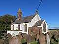
 Mouswald Parish Church - geograph.org.uk - 1065133.jpg 640 × 424; 191 KB
-
 Mouswald Parish Church - geograph.org.uk - 1870161.jpg 2,549 × 1,816; 797 KB
-
 Mouswald Parish Church - geograph.org.uk - 2060330.jpg 640 × 480; 56 KB
-
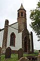
 Mouswald parish church - geograph.org.uk - 2949035.jpg 640 × 440; 53 KB
-
 Mouswald Parish Church - geograph.org.uk - 4191632.jpg 4,000 × 3,000; 2.67 MB
-
 Mouswald parish church - geograph.org.uk - 4236440.jpg 640 × 480; 56 KB
-
 Mouswald Parish Church - geograph.org.uk - 4527486.jpg 1,920 × 1,280; 1.48 MB
-
 Mouswald Parish Church - geograph.org.uk - 4527494.jpg 1,920 × 1,280; 1.11 MB
-
 Mouswald Parish Church - geograph.org.uk - 4527496.jpg 1,920 × 1,280; 1.15 MB
-
 Mouswald Parish Church - geograph.org.uk - 4527498.jpg 1,920 × 1,280; 1.38 MB
-
 Mouswald Parish Church - geograph.org.uk - 4527500.jpg 1,920 × 1,280; 1.25 MB
-
 Mouswald Parish Church - geograph.org.uk - 4527506.jpg 1,280 × 1,920; 1.36 MB
-
 Mouswald Parish Church - geograph.org.uk - 4527509.jpg 1,920 × 1,280; 1.72 MB
-
 Mouswald Parish Church - geograph.org.uk - 4527510.jpg 1,920 × 1,280; 1.31 MB
-
 Mouswald Parish Church - geograph.org.uk - 4527513.jpg 1,920 × 1,280; 1.32 MB
-
 Mouswald Parish Church - geograph.org.uk - 4527515.jpg 1,920 × 1,280; 1.27 MB
-
 Mouswald Parish Church - geograph.org.uk - 4527519.jpg 1,920 × 1,280; 1.33 MB
-
 Mouswald Parish Church - geograph.org.uk - 4900452.jpg 3,289 × 2,190; 2.69 MB
-
 Mouswald Parish church - geograph.org.uk - 5686750.jpg 1,600 × 900; 323 KB
-
 Mouswald, Mill Cottage - geograph.org.uk - 2520118.jpg 640 × 480; 77 KB
-
 Mouswald, old road-sign at Cleughbrae - geograph.org.uk - 2520115.jpg 480 × 640; 114 KB
-
 Mouswald, postbox № DG1 117, Cleughbrae - geograph.org.uk - 2520123.jpg 480 × 640; 104 KB
-
 New fencing on Lochar Moss near Dumfries - geograph.org.uk - 5750044.jpg 3,128 × 2,346; 3.01 MB
-
 No Stopping signs at Breconrae - geograph.org.uk - 3226976.jpg 2,058 × 1,458; 605 KB
-
 Old fence on Lochar Moss by Dumfries - geograph.org.uk - 5750055.jpg 3,128 × 2,346; 3.01 MB
-
 Old gateway next to Mouswald Burn near Dumfries - geograph.org.uk - 5749966.jpg 3,128 × 2,346; 3.13 MB
-

-

-

-
 One mile to the dual carriageway - geograph.org.uk - 3226992.jpg 1,920 × 1,320; 413 KB
-
 Ordnance Survey Cut Mark - geograph.org.uk - 4261909.jpg 4,000 × 3,000; 4.03 MB
-
 Ordnance Survey Flush Bracket G4253 - geograph.org.uk - 4263439.jpg 4,000 × 3,000; 3.12 MB
-
 Ordnance Survey Flush Bracket G69 - geograph.org.uk - 4263423.jpg 4,000 × 3,000; 3.46 MB
-
 Ordnance Survey Flush Bracket G70 - geograph.org.uk - 4263398.jpg 4,000 × 3,000; 4.14 MB
-
 Panteth-hill Cottage - geograph.org.uk - 2887607.jpg 640 × 480; 63 KB
-
 Panteth-hill Cottage - geograph.org.uk - 2887611.jpg 640 × 480; 53 KB
-
 Panteth-hill Cottage - geograph.org.uk - 2887620.jpg 640 × 480; 61 KB
-
 Passing Byeloch on the A75 - geograph.org.uk - 3225976.jpg 2,256 × 1,401; 527 KB
-
 Pylon and cottages - geograph.org.uk - 4900444.jpg 2,336 × 3,504; 2.34 MB
-
 Road at Mouswald - geograph.org.uk - 4527467.jpg 1,920 × 1,280; 1.11 MB
-
 Road in Mouswald - geograph.org.uk - 4527523.jpg 1,920 × 1,280; 1.48 MB
-
 Road junction west of Woodside - geograph.org.uk - 3477164.jpg 640 × 366; 53 KB
-
 Road past Townfoot, Mouswald - geograph.org.uk - 1862110.jpg 1,600 × 1,200; 734 KB
-
 Road to Mouswald Banks - geograph.org.uk - 2887192.jpg 484 × 640; 82 KB
-
 Road to Woodleigh - geograph.org.uk - 2887593.jpg 640 × 480; 53 KB
-
 Road under a railway bridge, Mouswald - geograph.org.uk - 1906600.jpg 600 × 800; 130 KB
-
 Rural road in Mouswald - geograph.org.uk - 1906622.jpg 600 × 800; 153 KB
-
 Rural road in Mouswald - geograph.org.uk - 4900322.jpg 3,504 × 2,336; 3.34 MB
-
 Rural road, near Racks Moss in Mouswald - geograph.org.uk - 1906616.jpg 800 × 600; 161 KB
-
 Silage field at Langdyke - geograph.org.uk - 1910032.jpg 1,024 × 768; 171 KB
-
 Silage field at Langdyke - geograph.org.uk - 1910241.jpg 1,024 × 768; 192 KB
-
 Silt and verdure on Mouswald Burn banks near Dumfries - geograph.org.uk - 5749975.jpg 3,128 × 2,346; 2.77 MB
-
 Solway Beetles - geograph.org.uk - 1910245.jpg 1,024 × 768; 139 KB
-
 Spring barley at Horseholm - geograph.org.uk - 1273051.jpg 640 × 480; 74 KB
-
 Steep bank near East Raffles - geograph.org.uk - 1910231.jpg 1,024 × 768; 203 KB
-
 Storage Area - geograph.org.uk - 2887590.jpg 640 × 480; 123 KB
-
 Sunset - geograph.org.uk - 6218349.jpg 2,253 × 1,690; 985 KB
-

-
 The B724 passing Mouswald Cemetery - geograph.org.uk - 2060350.jpg 640 × 480; 44 KB
-
 The B724 to Dumfries - geograph.org.uk - 4527473.jpg 1,920 × 1,280; 408 KB
-
 The cemetery at Mouswald - geograph.org.uk - 3626444.jpg 1,024 × 768; 151 KB
-
 The cemetery gates at Mouswald - geograph.org.uk - 3626393.jpg 1,024 × 768; 134 KB
-
 The edge of the forest at Horseholm - geograph.org.uk - 1273389.jpg 640 × 480; 68 KB
-
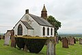
 The Parish Church at Mouswald - geograph.org.uk - 3626451.jpg 1,024 × 768; 150 KB
-
 The Raffles Burn - geograph.org.uk - 1910224.jpg 1,024 × 768; 167 KB
-

-
 The turning to Mouswald - geograph.org.uk - 3226978.jpg 2,129 × 1,411; 538 KB
-
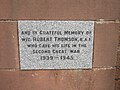
 The War Memorial at Mouswald - geograph.org.uk - 3626399.jpg 768 × 1,024; 179 KB
-
 The War Memorial at Mouswald - geograph.org.uk - 3626402.jpg 1,024 × 768; 281 KB
-
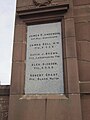 The War Memorial at Mouswald - geograph.org.uk - 3626405.jpg 768 × 1,024; 171 KB
-
 The War Memorial at Mouswald - geograph.org.uk - 3626411.jpg 1,024 × 768; 188 KB
-
 Towards Criffel - geograph.org.uk - 4362412.jpg 640 × 386; 77 KB
-
 Track and cows, Racks Moss - geograph.org.uk - 1906610.jpg 800 × 600; 170 KB
-
 Track to Panteth Hill - geograph.org.uk - 2887615.jpg 640 × 480; 86 KB
-
 Track to Panteth-hill - geograph.org.uk - 2887583.jpg 480 × 640; 108 KB
-
 Train tracks near Mouswald - geograph.org.uk - 1862109.jpg 1,600 × 1,200; 707 KB
-
 Un-metalled road - geograph.org.uk - 4900407.jpg 3,504 × 2,336; 2.49 MB
-
 View to the Criffel - geograph.org.uk - 2887144.jpg 640 × 480; 71 KB
-
 View to the Criffel - geograph.org.uk - 2887601.jpg 640 × 480; 58 KB
-
 Wath Burn - geograph.org.uk - 4900364.jpg 3,504 × 2,336; 4.41 MB
-
 Wee woodland clearing west of Mousland Burn near Dumfries - geograph.org.uk - 5749958.jpg 3,128 × 2,346; 2.66 MB
-
 West Raffles - geograph.org.uk - 2887625.jpg 640 × 480; 57 KB
-
 West Raffles - geograph.org.uk - 2887629.jpg 640 × 480; 74 KB
-
 West Raffles - geograph.org.uk - 2887630.jpg 640 × 480; 61 KB
-
 Woodside - geograph.org.uk - 2887076.jpg 640 × 464; 59 KB
-
 Woodside - geograph.org.uk - 2887124.jpg 640 × 480; 72 KB


