Category:Mountain Ash West
Jump to navigation
Jump to search
community in Rhondda Cynon Taf, Wales  | |||||
| Upload media | |||||
| Instance of | |||||
|---|---|---|---|---|---|
| Location | Rhondda Cynon Taf, Wales | ||||
 | |||||
Subcategories
This category has the following 2 subcategories, out of 2 total.
F
M
Media in category "Mountain Ash West"
The following 133 files are in this category, out of 133 total.
-
 "L" for Leather, Mountain Ash - geograph.org.uk - 3827900.jpg 800 × 648; 129 KB
-
 2024 Wales Rhondda Cynon Taf Community Mountain Ash West map.svg 512 × 737; 369 KB
-

-

-
 Aberdare Road houses, Mountain Ash - geograph.org.uk - 3854412.jpg 800 × 660; 120 KB
-

-
 Aberdare-Mountain Ash boundary marker - geograph.org.uk - 3857579.jpg 800 × 775; 211 KB
-
 Afon Cynon downstream, Mountain Ash - geograph.org.uk - 3830580.jpg 800 × 526; 129 KB
-

-

-
 Air Training Corps Mountain Ash - geograph.org.uk - 3826204.jpg 800 × 507; 99 KB
-

-
 Barclays Bank, Mountain Ash - geograph.org.uk - 3854340.jpg 680 × 800; 116 KB
-
 Bella Mima, Miskin - geograph.org.uk - 3826168.jpg 800 × 525; 96 KB
-

-

-
 Bruce Street, Mountain Ash - geograph.org.uk - 3827974.jpg 800 × 644; 158 KB
-

-
 Coal train at Mountain Ash - geograph.org.uk - 5293094.jpg 3,643 × 2,732; 4.08 MB
-

-
 Commercial Street benches, Mountain Ash - geograph.org.uk - 3854353.jpg 800 × 795; 231 KB
-
 Commercial Street houses, Mountain Ash - geograph.org.uk - 3854355.jpg 800 × 592; 139 KB
-

-
 Crags above the Cynon Valley - geograph.org.uk - 4950623.jpg 3,000 × 4,000; 4.09 MB
-

-
 Danish Bacon Bar, Mountain Ash - geograph.org.uk - 3836599.jpg 786 × 800; 164 KB
-

-
 Darranlas Post Office, Mountain Ash - geograph.org.uk - 1879824.jpg 414 × 640; 64 KB
-
 Dereliction in Darran Road, Mountain Ash - geograph.org.uk - 3827937.jpg 800 × 592; 135 KB
-

-
 Du a Gwyn club in Mountain Ash - geograph.org.uk - 3828065.jpg 800 × 634; 119 KB
-

-

-
 Eden Hair ^ Beauty, Mountain Ash - geograph.org.uk - 3827907.jpg 800 × 736; 138 KB
-
 Entrance to Fernhill railway station - geograph.org.uk - 3854477.jpg 800 × 525; 159 KB
-
 Fernhill level crossing - geograph.org.uk - 3857436.jpg 800 × 600; 221 KB
-
 Fernhill railway station access path - geograph.org.uk - 3857469.jpg 800 × 600; 237 KB
-
 Fernhill railway station, Mid Glamorgan - geograph.org.uk - 3305858.jpg 1,024 × 768; 282 KB
-
 Fernhill station - geograph.org.uk - 6101923.jpg 2,048 × 1,536; 1.2 MB
-
 From bank to flower shop in Mountain Ash - geograph.org.uk - 3828088.jpg 800 × 643; 136 KB
-
 Glenboi houses, Fernhill, Mountain Ash - geograph.org.uk - 3854472.jpg 800 × 646; 130 KB
-
 Glenboi, Fernhill, Mountain Ash - geograph.org.uk - 3854486.jpg 800 × 800; 167 KB
-
 Glenbrook, Fernhill, Mountain Ash - geograph.org.uk - 3854466.jpg 608 × 640; 87 KB
-
 Harcourt Road, Mountain Ash - geograph.org.uk - 3854403.jpg 730 × 800; 132 KB
-
 Henry Street bus stop in Mountain Ash - geograph.org.uk - 3854334.jpg 800 × 717; 149 KB
-
 Henry Street car park, Mountain Ash - geograph.org.uk - 3827880.jpg 800 × 503; 85 KB
-

-
 Hillside track above Mountain Ash - geograph.org.uk - 4950619.jpg 4,000 × 3,000; 4.04 MB
-
 Home (vintage and new), Mountain Ash - geograph.org.uk - 3836611.jpg 800 × 662; 143 KB
-

-
 Iceland, Mountain Ash - geograph.org.uk - 3827922.jpg 800 × 622; 115 KB
-

-

-
 Japanese Knotweed, Fernhill - geograph.org.uk - 5510288.jpg 1,024 × 768; 290 KB
-
 Kingcraft Street, Mountain Ash - geograph.org.uk - 1879799.jpg 640 × 556; 83 KB
-
 KR Conveyancing in Mountain Ash - geograph.org.uk - 3854336.jpg 800 × 785; 149 KB
-
 Lasco Hair Centre, Mountain Ash - geograph.org.uk - 3827990.jpg 800 × 775; 130 KB
-
 Lloyds Bank Mountain Ash - geograph.org.uk - 3828052.jpg 800 × 633; 117 KB
-

-
 Mountain Ash Boxing Club - geograph.org.uk - 3828175.jpg 800 × 783; 159 KB
-
 Mountain Ash Community Day Centre - geograph.org.uk - 3827945.jpg 800 × 463; 89 KB
-
 Mountain Ash railway station footbridge - geograph.org.uk - 3852814.jpg 800 × 688; 143 KB
-
 Mountain Ash railway station, Mid Glamorgan - geograph.org.uk - 3305090.jpg 1,024 × 768; 208 KB
-
 Mountain Ash railway station, Mid Glamorgan - geograph.org.uk - 3305091.jpg 1,024 × 768; 250 KB
-
 Mountain Ash RFC clubhouse, Mountain Ash - geograph.org.uk - 3828069.jpg 800 × 588; 116 KB
-
 Mountain Ash telephone exchange - geograph.org.uk - 3825861.jpg 800 × 521; 111 KB
-
 Mountain View, Mountain Ash - geograph.org.uk - 3854357.jpg 800 × 644; 106 KB
-
 Napier Street, Mountain Ash - geograph.org.uk - 1889931.jpg 640 × 427; 67 KB
-
 Napier Street, Mountain Ash - geograph.org.uk - 3828121.jpg 800 × 759; 159 KB
-
 New U Hair Design in Mountain Ash - geograph.org.uk - 3854354.jpg 800 × 682; 166 KB
-

-
 Notices near Fernhill level crossing - geograph.org.uk - 3857500.jpg 799 × 800; 238 KB
-
 Ordnance Survey Cut Mark - geograph.org.uk - 5657840.jpg 640 × 453; 74 KB
-
 Ordnance Survey Cut Mark - geograph.org.uk - 5657848.jpg 640 × 488; 77 KB
-
 Ordnance Survey Cut Mark - geograph.org.uk - 5657852.jpg 640 × 350; 77 KB
-
 Ordnance Survey Cut Mark - geograph.org.uk - 5657861.jpg 640 × 461; 105 KB
-
 Ordnance Survey Cut Mark - geograph.org.uk - 5657863.jpg 640 × 460; 116 KB
-
 Ordnance Survey Cut Mark - geograph.org.uk - 5657866.jpg 640 × 417; 73 KB
-
 Ordnance Survey Cut Mark - geograph.org.uk - 5657869.jpg 640 × 609; 154 KB
-
 Ordnance Survey Cut Mark - geograph.org.uk - 5657876.jpg 640 × 372; 67 KB
-
 Ordnance Survey Cut Mark - geograph.org.uk - 5657878.jpg 640 × 384; 69 KB
-
 Ordnance Survey Cut Mark - geograph.org.uk - 5657881.jpg 640 × 410; 109 KB
-
 Our Lady's Primary School, Mountain Ash - geograph.org.uk - 3826161.jpg 800 × 497; 127 KB
-

-
 Path descending to Fernhill - geograph.org.uk - 4950625.jpg 4,000 × 3,000; 3.84 MB
-

-

-
 Pryce Street, Mountain Ash - geograph.org.uk - 3854338.jpg 739 × 800; 129 KB
-

-

-
 Quality Fruit in Mountain Ash - geograph.org.uk - 3854335.jpg 800 × 800; 171 KB
-
 Railway compound, Miskin - geograph.org.uk - 3920457.jpg 800 × 575; 129 KB
-
 Railway line - geograph.org.uk - 6101916.jpg 2,048 × 1,536; 1.09 MB
-
 Railway Station, Mountain Ash - geograph.org.uk - 5510457.jpg 1,024 × 812; 179 KB
-
 Rhondda Cynon Taf Wales communities - Mountain Ash West locator.png 670 × 1,010; 156 KB
-
 Rhos House Surgery in Mountain Ash - geograph.org.uk - 3827955.jpg 800 × 543; 110 KB
-
 River footbridge, Mountain Ash - geograph.org.uk - 3982709.jpg 800 × 600; 206 KB
-
 Riverside path in Mountain Ash - geograph.org.uk - 3852828.jpg 800 × 547; 156 KB
-
 Riverside path, Mountain Ash - geograph.org.uk - 3982772.jpg 800 × 701; 114 KB
-
 Riverside railway signal, Mountain Ash - geograph.org.uk - 3854433.jpg 511 × 640; 172 KB
-
 Road, railway and river, Mountain Ash - geograph.org.uk - 3854444.jpg 800 × 600; 142 KB
-

-
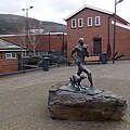 Sculpture in Oxford Street, Mountain Ash - geograph.org.uk - 3827968.jpg 800 × 799; 182 KB
-
 SE from Mountain Ash railway station - geograph.org.uk - 3882061.jpg 800 × 723; 221 KB
-

-

-

-

-

-
 Steps up to Llys yr Onnen, Mountain Ash - geograph.org.uk - 3825865.jpg 800 × 784; 277 KB
-
 The Insurance Centre in Mountain Ash - geograph.org.uk - 3828112.jpg 800 × 589; 125 KB
-
 The Napiers Arms, Mountain Ash - geograph.org.uk - 1890090.jpg 640 × 554; 72 KB
-
 Tony's Convenience Store in Mountain Ash - geograph.org.uk - 3827953.jpg 675 × 800; 153 KB
-

-

-

-

-
 Two shades of green in Fernhill - geograph.org.uk - 3857551.jpg 800 × 544; 158 KB
-

-
 Union Street, Mountain Ash - geograph.org.uk - 3854343.jpg 714 × 800; 156 KB
-

-
 Upland track above Mountain Ash - geograph.org.uk - 4950616.jpg 4,000 × 3,000; 3.6 MB
-
 Upland walls near Mountain Ash - geograph.org.uk - 4950610.jpg 4,000 × 3,000; 4.25 MB
-

-

-

-

-
 W railway sign, Mountain Ash - geograph.org.uk - 3854459.jpg 800 × 727; 304 KB
-
 Welcome to Mountain Ash - geograph.org.uk - 3948196.jpg 800 × 473; 79 KB
-

-
 Wonderful in Mountain Ash - geograph.org.uk - 3854356.jpg 800 × 729; 164 KB
-

-


,_Mountain_Ash_-_geograph.org.uk_-_3836611.jpg)


