Category:Mount Climie
hill in New Zealand | |||||
| Upload media | |||||
| Instance of | |||||
|---|---|---|---|---|---|
| Located in protected area | |||||
| Location | Wellington Region, New Zealand | ||||
| Mountain range | |||||
| Elevation above sea level |
| ||||
 | |||||
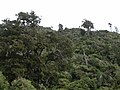
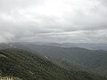
Mount Climie is on a ridgeline in the Pakuratahi Forest to the south and east of Upper Hutt in New Zealand. The ridge forms part of the northern skyline of the Remutaka Range that can be seen across the harbour from Wellington City. From the ridgeline, in good conditions there are views to the west across the Mangaroa and Hutt Valleys to Mana Island, Cook Strait and the South Island. The Wairapapa region can be seen to the east from the ridgeline. The track to Mount Climie is a steep 4WD road (closed to the public), that starts from the upper picnic area at the Tunnel Gully recreation area off Plateau Road. The track provides an opportunity to see how vegetation in the northern Remutaka Range changes with increases in altitude and exposure to wind.
Media in category "Mount Climie"
The following 7 files are in this category, out of 7 total.
-
 Low clouds passing over the Rimutakas south of Mount Climie.jpg 1,024 × 768; 268 KB
-
 Mountain Cabbage Trees and ferns on Mount Climie.jpg 1,024 × 768; 342 KB
-
 Native bush with Rimu trees on Mount Climie.jpg 1,024 × 768; 301 KB
-
 Nothofagus menziesii on Mount Climie.jpg 1,024 × 768; 332 KB
-
 View down Hutt Valley from Mount Climie.jpg 1,024 × 768; 306 KB
-
 View south from Mount Climie.jpg 1,024 × 768; 218 KB
-
 View towards Wairarapa from Mount Climie.jpg 1,024 × 768; 258 KB


