Category:Motukokako Island
Jump to navigation
Jump to search
island in New Zealand  | |||||
| Upload media | |||||
| Instance of | |||||
|---|---|---|---|---|---|
| Named after |
| ||||
| Location | Far North District, Northland Region, New Zealand | ||||
| Located in or next to body of water | |||||
| Width |
| ||||
| Length |
| ||||
| Population |
| ||||
| Area |
| ||||
| Elevation above sea level |
| ||||
 | |||||
Motukokako Island (Piercy Island) lies off Cape Brett, east of the Bay of Islands in New Zealand and is also known as "The Hole in the Rock".
Subcategories
This category has only the following subcategory.
H
Media in category "Motukokako Island"
The following 8 files are in this category, out of 8 total.
-
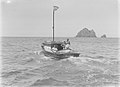
 "Seagull Auckland" boat near Motukokako Island (AM 87931-1).jpg 1,275 × 954; 681 KB
-
 "Seagull Auckland" boat near Motukokako Island (AM 87932-1).jpg 1,275 × 948; 695 KB
-
 .00 0665 Bay of Island (New Zealand) - Motukokako Island (Piercy Island).jpg 3,300 × 2,200; 8.19 MB
-
 Bledisloe Rosemary Cape Brett 1934 (AM 82376-1).jpg 1,275 × 923; 564 KB
-
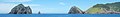 Cape Brett banner Motukokako Island (Piercy Island) off Cape Brett.jpg 4,860 × 694; 937 KB
-
 Motukokako Island (Piercy Island) off Cape Brett.jpg 4,860 × 2,880; 3.93 MB
-
 Piercy Island Alma G (AM 82375-1).jpg 1,275 × 915; 562 KB
-
 View of boat in the sea (AM 76100-1).jpg 1,275 × 945; 669 KB
.jpg)
.jpg)
_-_Motukokako_Island_(Piercy_Island).jpg)
.jpg)
_off_Cape_Brett.jpg)
.jpg)
.jpg)
_off_Cape_Brett.jpg)