Category:Monterey Bay National Marine Sanctuary
Jump to navigation
Jump to search
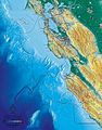
English: The MBNMS—Monterey Bay National Marine Sanctuary — protecting marine areas and the adjacent Pacific Coast of California, including Monterey Bay.
- MBNMS is the largest U.S. National Marine Sanctuary, and has a shoreline length of 276 miles (444 km).
- The Monterey Bay National Marine Sanctuary stretches from just north of the Golden Gate Bridge in Marin County; through coasts and waters of San Francisco and San Mateo County, Monterey Bay and the open coasts of Santa Cruz County and Monterey Counties; to Cambria in northern San Luis Obispo County.
- The National Marine Sanctuary provides resource protection, research, education, and public use for one of the world’s most diverse marine ecosystems.
marine protected area in California, USA  | |||||
| Upload media | |||||
| Instance of |
| ||||
|---|---|---|---|---|---|
| Named after | |||||
| Location |
| ||||
| Located in or next to body of water | |||||
| Operator | |||||
| IUCN protected areas category | |||||
| Inception |
| ||||
| Area |
| ||||
| official website | |||||
 | |||||
Subcategories
This category has only the following subcategory.
Media in category "Monterey Bay National Marine Sanctuary"
The following 131 files are in this category, out of 131 total.
-
 Central California Marine Sanctuaries.jpg 479 × 658; 128 KB
-
 Black Oystercatcher (44773757661).jpg 6,400 × 4,628; 23.63 MB
-
 Cockerells (44766003871).jpg 1,620 × 1,080; 1.93 MB
-
 Common Dolphins (29977297367).jpg 4,288 × 2,848; 5.22 MB
-
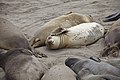
 Elephant Seal (24769388147).jpg 3,072 × 2,048; 3.19 MB
-
 Elephant Seal (42962970420).jpg 4,488 × 3,216; 10.16 MB
-
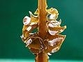
 Fauchea laciniata and Stylaster californicus.jpg 1,200 × 800; 951 KB
-
 Fish-Eating Anemone - Urticina piscivora (44194337494).jpg 1,600 × 1,067; 1.04 MB
-
 Giant Dendronotid - Dendronotus Iris (43863888705).jpg 1,618 × 1,080; 1.51 MB
-
 Hermissenda crassicornis y Botryocladia pseudodichotoma.jpg 1,200 × 800; 78 KB
-
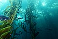
 Kelp forest.jpg 240 × 313; 32 KB
-
 Leather Seastars (43781574824).jpg 1,620 × 1,080; 1.5 MB
-
 Leather Star And Purple Sea Urchins (40176629520).jpg 5,616 × 3,744; 7.47 MB
-
 Lobate Comb Jelly (40164874905).jpg 3,602 × 2,573; 3.05 MB
-
 MBNMS - anemone (31356289925).jpg 6,000 × 4,000; 4.8 MB
-
 MBNMS - anemone (31361235892).jpg 3,831 × 2,737; 3.41 MB
-
 MBNMS - Anemone in Kelp (27225664213).jpg 5,616 × 3,744; 5.69 MB
-
 MBNMS - big waves (27371172043).jpg 2,400 × 1,350; 1.22 MB
-
 MBNMS - Cabezon (27667876284).jpg 1,600 × 1,066; 1.54 MB
-
 MBNMS - Coast (29714659650).jpg 3,872 × 2,592; 6.09 MB
-
 MBNMS - container study (27842142475).jpg 1,920 × 1,080; 229 KB
-
 MBNMS - egg yolk jelly (27226603853).jpg 1,200 × 800; 90 KB
-
 MBNMS - Elephant Seal (34250171062).jpg 1,600 × 1,067; 1,001 KB
-
 MBNMS - Elephant Seal Pup (27658309196).jpg 3,008 × 2,000; 858 KB
-
 MBNMS - Elephant Seal Pups - Point Piedras Blancas (33845616811).jpg 3,504 × 2,336; 4.27 MB
-
 MBNMS - elephant seals (27908134301).jpg 1,200 × 800; 413 KB
-
 MBNMS - elephant seals (28128851655).jpg 5,616 × 3,744; 7.84 MB
-
 MBNMS - Elephant Seals (34513824396).jpg 3,872 × 2,592; 5.3 MB
-
 MBNMS - Fish In Kelp Forest (31363169882).jpg 6,000 × 4,000; 4.9 MB
-
 MBNMS - harbor seal (27225662993).jpg 1,621 × 1,080; 228 KB
-
 MBNMS - humpback (27229364874).jpg 3,869 × 2,581; 4.8 MB
-
 MBNMS - humpback tail (27881749372).jpg 1,600 × 2,404; 1.6 MB
-
 MBNMS - Invasive Bryozoan Watersipora (33310174655).jpg 3,072 × 2,048; 3.58 MB
-
 MBNMS - Jump For Joy (27368527863).jpg 4,096 × 2,160; 5.57 MB
-
 MBNMS - Juvenile Pinto Abalone (27667876484).jpg 1,200 × 800; 554 KB
-
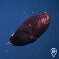
 MBNMS - Juvenile Vampire Squid (27667875204).jpg 1,431 × 1,080; 879 KB
-
 MBNMS - kelp forest (28127778655).jpg 1,600 × 1,067; 893 KB
-
 MBNMS - kelp forest - NOAA (26972424160).jpg 960 × 376; 380 KB
-
 MBNMS - Male Elephant Seal (28132679803).jpg 3,008 × 2,000; 3.16 MB
-
 MBNMS - Male Elephant Seal And Shorebird (33181525221).jpg 3,008 × 2,000; 2.66 MB
-
 MBNMS - mola mola (27229365384).jpg 1,200 × 800; 673 KB
-
 MBNMS - Napping elephant seals (27229363704).jpg 1,600 × 1,067; 720 KB
-
 MBNMS - Navanax Inermis Pursuing And Eating Herimessenda Opalescens- (33304905435).jpg 1,471 × 1,012; 1.02 MB
-
 MBNMS - northern elephant seal (27761762081).jpg 1,800 × 1,060; 1.17 MB
-
 MBNMS - Nudibranch Eggs (27625264334).jpg 1,200 × 858; 505 KB
-
 MBNMS - Otters (27950525066).jpg 2,896 × 1,944; 3.63 MB
-
 MBNMS - pelagic red crab (27230141934).jpg 1,512 × 1,080; 405 KB
-
 MBNMS - pelagic red crabs (27230142014).jpg 1,600 × 1,067; 368 KB
-
 MBNMS - Photo from Monterey Harbor (33310174485).jpg 1,600 × 1,067; 710 KB
-
 MBNMS - red turban snail (27985947335).jpg 1,620 × 1,080; 688 KB
-
 MBNMS - Sanderlings (28748018825).jpg 1,280 × 960; 914 KB
-
 MBNMS - sea hare mollusk (29894801312).jpg 1,600 × 1,067; 1.07 MB
-
 MBNMS - sea nettle Photo from Monterey Harbor. (28128850695).jpg 1,000 × 667; 504 KB
-
 MBNMS - Sea Otters In Eel grass Bed (33029439553).jpg 1,200 × 800; 636 KB
-
 MBNMS - sea scape (27740030222).jpg 3,264 × 2,448; 4.52 MB
-
 MBNMS - sea urchin-breakwater (27667880474).jpg 1,200 × 857; 562 KB
-
 MBNMS - Steve Lonhart And Hooded Nudibranch (30007194805).jpg 1,600 × 1,067; 591 KB
-
 MBNMS - Wind Sailing (27551308752).jpg 2,000 × 3,008; 3.96 MB
-
 MBNMS - wolfeel NOAA (27082149044).jpg 3,088 × 1,739; 920 KB
-
 MBNMS - Yellow Ruffle Sponge - Davidson Seamount (31516263452).jpg 2,048 × 1,536; 2.35 MB
-
 MBNMS -- ACCESS cruise hoopnet (34787511333).jpg 4,288 × 2,848; 7.53 MB
-
 MBNMS -- Benthic Octopus (35991148936).jpg 2,048 × 1,536; 2.19 MB
-
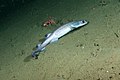 MBNMS -- Filetail Catshark (35564353153).jpg 1,600 × 1,068; 925 KB
-
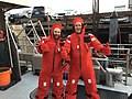 MBNMS -- Gumby Suits (35976288680).jpg 4,032 × 3,024; 4.7 MB
-
 MBNMS -- La Jolla Leopard Sharks (36327877766).jpg 4,752 × 3,168; 6.3 MB
-
 MBNMS -jellyfish (27231488813).jpg 2,048 × 1,536; 2.11 MB
-
 MBNMS albino Risso's dolphin (49041023267).jpg 1,080 × 1,080; 1,004 KB
-
 MBNMS Asian kelp (48770803941).jpg 1,200 × 900; 784 KB
-
 MBNMS bat stars eat moon jelly (48771005228).jpg 1,600 × 1,066; 1.83 MB
-
 MBNMS Black Footed Albatross (48779360772).jpg 6,034 × 3,523; 15.32 MB
-
 MBNMS burrowing owl (48770612813).jpg 4,096 × 2,160; 6.36 MB
-
 MBNMS California sea lions on buoy (49040303598).jpg 1,080 × 1,080; 907 KB
-
 MBNMS Cat shark (48783009617).jpg 1,600 × 1,068; 939 KB
-
 MBNMS child ocean guardians (50094468626).jpg 4,096 × 2,160; 6.76 MB
-
 MBNMS common dolphins breaching (49041021952).jpg 2,048 × 2,048; 1.81 MB
-
 MBNMS Curious Octopus (49050768516).jpg 1,851 × 1,046; 764 KB
-
 MBNMS Davidson Map Update.pdf 3,664 × 5,433; 3.73 MB
-
 MBNMS elephant seal yawning (48770851737).jpg 4,503 × 2,813; 8.68 MB
-
 MBNMS elephant seals play fighting (50199588696).jpg 5,472 × 3,541; 14.61 MB
-
 MBNMS Fishing (50041730607).jpg 7,448 × 5,504; 37.2 MB
-
 MBNMS golden eagle (49040306548).jpg 2,048 × 2,048; 2.84 MB
-
 MBNMS humpback whale spy hop with seabird (49040810861).jpg 1,080 × 1,080; 874 KB
-
 MBNMS humpback whale surrounded by seabirds (50199589581).jpg 2,000 × 1,333; 1.92 MB
-
 MBNMS humpback whales feeding (49041019637).jpg 2,048 × 2,048; 570 KB
-
 MBNMS hungry sea otter (50199856232).jpg 2,000 × 1,333; 1.95 MB
-
 MBNMS juvenile vampire squid (49041024167).jpg 1,080 × 1,080; 535 KB
-
 MBNMS kayaker too close to humpback whale (49040807441).jpg 2,048 × 2,048; 363 KB
-
 MBNMS Leucistic Common Murre (49531333937).jpg 1,500 × 1,000; 1.42 MB
-
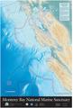
 Mbnms map.jpg 600 × 769; 142 KB
-
 MBNMS nudibranchs crawl over invasive bryozoan (48770472943).jpg 3,072 × 2,048; 3.37 MB
-
 MBNMS Octopus at Davidson Seamount (49640020177).jpg 1,920 × 1,080; 1.11 MB
-
 MBNMS Ohners Dorid (49123343658).jpg 1,080 × 1,080; 900 KB
-
 MBNMS Orca (48778952158).jpg 6,084 × 3,876; 16.65 MB
-
 MBNMS orcas (48770853257).jpg 4,032 × 3,024; 5.79 MB
-
 MBNMS pelican flying (49040302473).jpg 2,048 × 2,048; 1.21 MB
-
 MBNMS Risso's dolphins (50040738188).jpg 1,500 × 1,200; 1.62 MB
-
 MBNMS Sand piper (50041289681).jpg 4,622 × 3,061; 6.93 MB
-
 MBNMS sea otters (49040807711).jpg 1,080 × 1,080; 134 KB
-
 MBNMS Southern Sea Otter (49946568407).jpg 1,500 × 1,500; 1.46 MB
-
 MBNMS Umbrella Octopus- Davidson Seamount (49518059852).jpg 1,920 × 1,080; 1.48 MB
-
 MBNMS Whale Fall at Davidson Seamount (49639154888).jpg 1,920 × 1,080; 1.28 MB
-
 MBNMS Whale Fall Octopuses (49050941487).jpg 1,851 × 1,093; 769 KB
-
 MBNMS White Lined Dorid (48783307412).jpg 1,200 × 900; 489 KB
-
 MBNMS Young Male Elephant Seals Mock Battling (49530842446).jpg 1,600 × 1,067; 751 KB
-
 Monterey Bay Cruise 2009-02-15 (3366305053).jpg 3,504 × 2,336; 1.6 MB
-
 Monterey Bay Cruise 2009-02-15 (3367128280).jpg 3,504 × 2,336; 2.53 MB
-
 Monterey Bay National Marine Sanctuary information sign 1.jpg 2,448 × 3,264; 2.75 MB
-
 Monterey Bay National Marine Sanctuary information sign 2.jpg 2,448 × 3,264; 2.74 MB
-
 Monterey Bay National Marine Sanctuary information sign 3.jpg 2,448 × 3,264; 2.6 MB
-
 Monterey Bay National Marine Sanctuary sea lion information sign.jpg 3,264 × 2,448; 2.79 MB
-
 Ocean Guardian (43863473115).jpg 3,648 × 5,472; 7.9 MB
-

-
 Osprey Shipwreck (48779156353).jpg 3,240 × 2,160; 5.06 MB
-
 Ribbon kelp (Alaria marginata).jpg 524 × 1,090; 137 KB
-
 Rocky Reef in Monterey Bay (43727105452).jpg 5,616 × 3,744; 9.92 MB
-
 Sanc0815 - Flickr - NOAA Photo Library.jpg 3,008 × 2,000; 904 KB
-
 Sanc0831 - Flickr - NOAA Photo Library.jpg 3,872 × 2,592; 5.18 MB
-
 Sanc0835 - Flickr - NOAA Photo Library.jpg 2,592 × 3,872; 5.24 MB
-
 Sanc0841 - Flickr - NOAA Photo Library.jpg 2,272 × 1,704; 1.21 MB
-
 Sanc0843 - Flickr - NOAA Photo Library.jpg 1,536 × 2,048; 2.05 MB
-
 Sanc0845 - Flickr - NOAA Photo Library.jpg 2,048 × 1,536; 1.2 MB
-
 Sanc0846 - Flickr - NOAA Photo Library.jpg 2,048 × 1,536; 1.25 MB
-
 Sanc0847 - Flickr - NOAA Photo Library.jpg 2,048 × 1,536; 1.03 MB
-
 Sanc0893 - Flickr - NOAA Photo Library.jpg 1,704 × 2,272; 506 KB
-
 Sea Lions - Monterey Bay National Marine Sanctuary (38030790705).jpg 3,504 × 2,336; 3.7 MB
-
 Shrimp On Invasive Bryozoan Watersipora Subtorquata (42003919455).jpg 1,200 × 800; 431 KB
-
 Sunflower Star - Pycnopodia Helianthoides (43101684160).jpg 1,200 × 800; 536 KB
-
 Trail sign for Calif Coastal Trail near Capitola.jpg 2,194 × 2,925; 2.33 MB
-
-
 View of urban runoff discharging to coastal waters.jpg 694 × 800; 119 KB
-
 Whale Disentanglement Training (43857663715).jpg 3,504 × 2,336; 4.72 MB

.jpg)
.jpg)
.jpg)
.jpg)
.jpg)

.jpg)
.jpg)


.jpg)
.jpg)
.jpg)
.jpg)
.jpg)
.jpg)
.jpg)
.jpg)
.jpg)
.jpg)
.jpg)
.jpg)
.jpg)
.jpg)
.jpg)
.jpg)
.jpg)
.jpg)
.jpg)
.jpg)
.jpg)
.jpg)
.jpg)
.jpg)
.jpg)
.jpg)
.jpg)
.jpg)
.jpg)
.jpg)
.jpg)
.jpg)
.jpg)
.jpg)
.jpg)
.jpg)
.jpg)
.jpg)
.jpg)
.jpg)
.jpg)
.jpg)
.jpg)
.jpg)
.jpg)
.jpg)
.jpg)
.jpg)
.jpg)
.jpg)
.jpg)
.jpg)
.jpg)
.jpg)
.jpg)
.jpg)
.jpg)
.jpg)
.jpg)
.jpg)
.jpg)
.jpg)
.jpg)
.jpg)
.jpg)
.jpg)
.jpg)
.jpg)
.jpg)
.jpg)
.jpg)
.jpg)
.jpg)
.jpg)
.jpg)

.jpg)
.jpg)
.jpg)
.jpg)
.jpg)
.jpg)
.jpg)
.jpg)
.jpg)
.jpg)
.jpg)
.jpg)
.jpg)
.jpg)
.jpg)
.jpg)
.jpg)


.jpg)
_Monterey_Bay_National_Marine_Sanctuary_(43101889980).jpg)
.jpg)
.jpg)
.jpg)


.jpg)
.jpg)
.jpg)

.jpg)

.jpg)
.jpg)
Categories:
- Nature reserves in California
- National Marine Sanctuaries
- California Coast
- Monterey Bay
- Parks in Marin County, California
- Parks in San Mateo County, California
- Parks in Santa Cruz County, California
- Parks in Monterey County, California
- Parks in San Luis Obispo County, California
- 1992 establishments in the United States
- Nature of the San Francisco Bay Area