Category:Monte Bertrand
Jump to navigation
Jump to search
|
Monte Bertrand has an entry on OpenStreetMap (show). |
Mountain of the Ligurian Alps  | |||||
| Upload media | |||||
| Instance of | |||||
|---|---|---|---|---|---|
| Location |
| ||||
| Mountain range | |||||
| Topographic prominence |
| ||||
| Topographic isolation |
| ||||
| Elevation above sea level |
| ||||
 | |||||
Subcategories
This category has the following 2 subcategories, out of 2 total.
C
P
Media in category "Monte Bertrand"
The following 5 files are in this category, out of 5 total.
-
 Cima Missun summit cross background Monte Bertrand.png 2,607 × 3,434; 12.72 MB
-
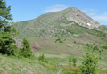 Monte Bertrand and Colla Rossa.png 2,537 × 1,749; 7.46 MB
-
 Monte Bertrand dal Monte della Guardia.png 4,138 × 2,314; 15.24 MB
-
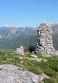
 Monte Bertrand summit cross and cairn.png 3,111 × 3,746; 11.55 MB
-
 Monte della Guardia ometto di vetta sfondo Monte Bertrand.png 2,474 × 3,540; 12.83 MB


