Category:Milnsbridge
Jump to navigation
Jump to search
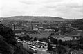
English: Milnsbridge is a district of Huddersfield, West Yorkshire, England 2.5 miles (4 km) west of the town centre, situated in the Colne Valley. The name is said to have derived from the water-powered mill and the bridge that stood alongside it in the 13th century.
district of Huddersfield, West Yorkshire, England  | |||||
| Upload media | |||||
| Instance of | |||||
|---|---|---|---|---|---|
| Part of | |||||
| Location | Kirklees, West Yorkshire, Yorkshire and the Humber, England | ||||
 | |||||
Subcategories
This category has the following 6 subcategories, out of 6 total.
Media in category "Milnsbridge"
The following 118 files are in this category, out of 118 total.
-
 A funny gap in Milnsbridge - geograph.org.uk - 654697.jpg 640 × 429; 91 KB
-

-
 Aldi - Scar Lane - geograph.org.uk - 4789904.jpg 640 × 480; 73 KB
-
 Armitage Bridge, Milnsbridge.jpg 1,200 × 799; 475 KB
-

-

-

-
 Bridge MVL3-75 - Scar Lane, Milnsbridge - geograph.org.uk - 920890.jpg 640 × 423; 185 KB
-
 Britannia Road - Scar Lane, Milnsbridge - geograph.org.uk - 920901.jpg 640 × 441; 238 KB
-

-
 Burdett Mill, Milnsbridge - geograph.org.uk - 843517.jpg 640 × 480; 84 KB
-
 Burdett Mills, Milnsbridge - geograph.org.uk - 1048273.jpg 640 × 431; 68 KB
-
 Chimney, Milnsbridge - geograph.org.uk - 1049457.jpg 419 × 640; 33 KB
-

-
 Christadelphian Hall - Morley Lane - geograph.org.uk - 4945222.jpg 640 × 435; 59 KB
-

-
 Cuckoo Bridge, Milnsbridge.jpg 4,000 × 2,248; 6.25 MB
-
 Derelict building on Tanyard Road - geograph.org.uk - 5059747.jpg 1,200 × 799; 382 KB
-
 Doctor's Surgery - Scar Lane, Milnsbridge - geograph.org.uk - 920906.jpg 640 × 468; 252 KB
-

-
 Elizabeth II postbox on Scar Lane, Milnsbridge - geograph.org.uk - 5966263.jpg 3,888 × 5,184; 7.81 MB
-
 Entrance to John Crowthers - geograph.org.uk - 843344.jpg 480 × 640; 89 KB
-
 Factory Lane - Milnsbridge - geograph.org.uk - 914439.jpg 578 × 640; 266 KB
-

-
 Footpath - Manchester Road, Milnsbridge - geograph.org.uk - 915065.jpg 525 × 640; 318 KB
-
 Footpath - Scar Lane, Milnsbridge - geograph.org.uk - 920888.jpg 537 × 640; 227 KB
-
 Footpath - Scar Lane, Milnsbridge - geograph.org.uk - 920899.jpg 482 × 640; 270 KB
-
 Former drill hall, Scar Lane, Golcar - geograph.org.uk - 4029914.jpg 2,000 × 1,500; 973 KB
-

-

-
 George Street Mills - geograph.org.uk - 402534.jpg 640 × 419; 52 KB
-
 George Street Mills - geograph.org.uk - 625068.jpg 413 × 640; 56 KB
-
 George Street Mills - geograph.org.uk - 641065.jpg 425 × 640; 64 KB
-

-
 George Street Mills, Milnsbridge - geograph.org.uk - 145077.jpg 640 × 405; 104 KB
-
 George Street Mills, powerhouse - geograph.org.uk - 729960.jpg 426 × 640; 94 KB
-
 George VI postbox on Scar Lane, Milnsbridge - geograph.org.uk - 5966267.jpg 2,816 × 4,513; 3.56 MB
-
 Horse and Groom, Milnsbridge (14764581329).jpg 2,354 × 2,354; 3.55 MB
-
 Huddersfield Canal at Milnsbridge - geograph.org.uk - 2214.jpg 480 × 357; 40 KB
-
 Huddersfield Canal east of Milnsbridge - geograph.org.uk - 2216.jpg 480 × 360; 39 KB
-
 Huddersfield Narrow Canal, Milnsbridge - geograph.org.uk - 1886130.jpg 1,024 × 768; 136 KB
-

-

-
 Huddersfield Narrow Canal, Milnsbridge - geograph.org.uk - 3130537.jpg 1,689 × 2,518; 863 KB
-
 Huddersfield Narrow Canal, Milnsbridge - geograph.org.uk - 3134523.jpg 1,977 × 2,147; 1.14 MB
-
 Huddersfield Narrow Canal, Milnsbridge - geograph.org.uk - 3134574.jpg 2,776 × 2,575; 1.6 MB
-

-

-

-

-
 Lipscomb Street - Scar Lane, Milnsbridge - geograph.org.uk - 921004.jpg 640 × 487; 253 KB
-

-
 Lock 10E, Huddersfield Narrow Canal - geograph.org.uk - 5059504.jpg 1,200 × 799; 497 KB
-
 Lock No 10E, Huddersfield Narrow Canal - geograph.org.uk - 849482.jpg 640 × 429; 143 KB
-
 Lock No 10E, Huddersfield Narrow Canal - geograph.org.uk - 849488.jpg 640 × 429; 119 KB
-
 Lock No 12E, Huddersfield Narrow Canal - geograph.org.uk - 849490.jpg 640 × 429; 127 KB
-
 Lock No 6E, Huddersfield Narrow Canal - geograph.org.uk - 849291.jpg 640 × 429; 119 KB
-
 Lock No 8E, Huddersfield Narrow Canal - geograph.org.uk - 849315.jpg 640 × 429; 113 KB
-
 Lock No 9E, Huddersfield Narrow Canal - geograph.org.uk - 849434.jpg 640 × 429; 106 KB
-

-

-

-
 Mills to dust, Milnsbridge - geograph.org.uk - 1049429.jpg 640 × 423; 52 KB
-
 Milnsbridge - geograph.org.uk - 341975.jpg 640 × 419; 114 KB
-
 Milnsbridge - geograph.org.uk - 486378.jpg 414 × 640; 44 KB
-
 Milnsbridge - geograph.org.uk - 486388.jpg 640 × 432; 50 KB
-
 Milnsbridge - Holme Mill and canal - geograph.org.uk - 2570860.jpg 1,200 × 1,600; 433 KB
-
 Milnsbridge - Manchester Road from Britannia Road - geograph.org.uk - 2570865.jpg 1,600 × 1,200; 1.14 MB
-
 Milnsbridge - Union Mill - geograph.org.uk - 2569766.jpg 1,600 × 1,200; 527 KB
-
 Milnsbridge - viaduct and mills - geograph.org.uk - 2569774.jpg 1,600 × 1,182; 659 KB
-

-
 Milnsbridge Basin.jpg 2,000 × 1,500; 1,016 KB
-
 Milnsbridge Bridge.jpg 1,200 × 799; 397 KB
-
 Milnsbridge canal scene - geograph.org.uk - 3134628.jpg 3,356 × 2,147; 2.33 MB
-
 Milnsbridge from Park Road West - geograph.org.uk - 2194755.jpg 640 × 427; 66 KB
-
 Milnsbridge from railway - geograph.org.uk - 2565201.jpg 640 × 435; 56 KB
-
 Milnsbridge from the "Pinfold" - geograph.org.uk - 486404.jpg 640 × 417; 57 KB
-
 Milnsbridge from the Pinfold - geograph.org.uk - 737913.jpg 640 × 435; 79 KB
-
 Milnsbridge industrial - geograph.org.uk - 2272416.jpg 3,648 × 2,736; 3.21 MB
-
 Milnsbridge Liberal Club - George Street - geograph.org.uk - 921007.jpg 640 × 472; 247 KB
-

-
 Milnsbridge mills - geograph.org.uk - 402533.jpg 640 × 432; 61 KB
-

-
 Milnsbridge with some elevation - geograph.org.uk - 2207444.jpg 640 × 414; 86 KB
-

-

-
 New Street - Milnsbridge - geograph.org.uk - 914453.jpg 640 × 479; 247 KB
-

-
 Radcliffe Road - Whiteley Street - geograph.org.uk - 4945360.jpg 640 × 480; 84 KB
-

-

-
 Savile Street - Crow Lane - geograph.org.uk - 4789917.jpg 640 × 480; 70 KB
-
 Savile Street - Market Street - geograph.org.uk - 4789821.jpg 640 × 458; 57 KB
-
 Spring Mill, Milnsbridge - geograph.org.uk - 843475.jpg 640 × 480; 84 KB
-
-
 Stonefield Mill, Milnsbridge - geograph.org.uk - 843465.jpg 640 × 480; 83 KB
-
 Tanyard Road,Milnsbridge - geograph.org.uk - 843190.jpg 640 × 480; 90 KB
-

-

-

-
-
 The Queen - Manchester Road, Milnsbridge - geograph.org.uk - 914446.jpg 640 × 498; 267 KB
-
 The Royal - Scar Lane, Milnsbridge - geograph.org.uk - 920903.jpg 640 × 529; 237 KB
-

-

-
 Union and Burdett Mills (geograph 2194774).jpg 640 × 414; 70 KB
-
 Union Mill,Milnsbridge - geograph.org.uk - 843452.jpg 640 × 480; 82 KB
-
 Union Mills, Milnsbridge - geograph.org.uk - 341965.jpg 403 × 640; 75 KB
-
 Union Mills, Milnsbridge - geograph.org.uk - 641082.jpg 433 × 640; 66 KB
-
 Union Mills, Milnsbridge, Linthwaite - geograph.org.uk - 629078.jpg 640 × 472; 64 KB
-

-

-
 View from Longwood Tower - Viaduct (3988477632).jpg 2,525 × 1,873; 4.96 MB
-

-

-

-
 Whiteley Street - Milnsbridge - geograph.org.uk - 914442.jpg 581 × 640; 256 KB
-
 Wood Street - geograph.org.uk - 1468011.jpg 640 × 480; 72 KB


,_Manchester_Road_A62,_Milnsbridge,_Linthwaite_-_geograph.org.uk_-_766601.jpg)


.jpg)


_-_geograph.org.uk_-_409713.jpg)

_-_geograph.org.uk_-_850283.jpg)


.jpg)


.jpg)


