Category:Milburn, Cumbria
Jump to navigation
Jump to search
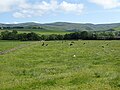
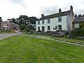
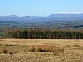
English: Milburn, Cumbria nestles at the Eastern edge of the Eden Valley as it meets the Pennine Mountain range. It lies some 200 feet above sea level directly beneath the highest point of the Pennines, Cross Fell. The area is predominated by farming and to the north of Milburn is the market town of Penrith and to the south, Appleby, the county town of the old county, Westmorland.
village and civil parish in Cumbria, England, United Kingdom Oct2003.jpg)  | |||||
| Upload media | |||||
| Instance of | |||||
|---|---|---|---|---|---|
| Location | Eden, Cumbria, North West England, England | ||||
 | |||||
Subcategories
This category has the following 4 subcategories, out of 4 total.
Media in category "Milburn, Cumbria"
The following 200 files are in this category, out of 321 total.
(previous page) (next page)-
 A very tough climb (1) - geograph.org.uk - 5007007.jpg 640 × 480; 258 KB
-
 A very tough climb (2) - geograph.org.uk - 5007013.jpg 640 × 480; 229 KB
-
 A very tough climb (3) - geograph.org.uk - 5007017.jpg 640 × 480; 231 KB
-
 Above Green Pot - geograph.org.uk - 1856852.jpg 480 × 640; 80 KB
-
 Above Knock Ore Gill - geograph.org.uk - 1856957.jpg 640 × 480; 70 KB
-
 Access road to NATS on Great Dun Fell - geograph.org.uk - 4694481.jpg 1,600 × 1,065; 693 KB
-
 Access road to NATS on Great Dun Fell - geograph.org.uk - 4694483.jpg 1,600 × 1,065; 542 KB
-
 Aerial ropeway pylon base - geograph.org.uk - 6107506.jpg 1,600 × 1,200; 498 KB
-
 Aerial ropeway remains above the Knock Ore Gill - geograph.org.uk - 6107503.jpg 1,600 × 1,200; 536 KB
-
 Angled rock plates in River Tees - geograph.org.uk - 6221181.jpg 1,600 × 1,200; 541 KB
-
 Barn on Marton Moor - geograph.org.uk - 136459.jpg 640 × 480; 93 KB
-
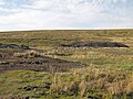
 Bog and peat banks on north-east ridge of Great Dun Fell - geograph.org.uk - 5432983.jpg 1,500 × 837; 1,002 KB
-
 Bound for Little Dun Fell - geograph.org.uk - 6106733.jpg 1,200 × 1,600; 554 KB
-
 Bridleway on west side of Great Dun Fell - geograph.org.uk - 2183243.jpg 2,000 × 1,123; 2.23 MB
-
 Burney Hill - geograph.org.uk - 1095083.jpg 640 × 480; 73 KB
-
 Burney Hill - geograph.org.uk - 1299544.jpg 640 × 427; 66 KB
-
 Burney Hill - geograph.org.uk - 2183176.jpg 2,000 × 1,123; 1.53 MB
-
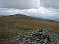
 Cairn on Great Dun Fell, Milburn - geograph.org.uk - 4341806.jpg 640 × 480; 169 KB
-
 Cairn on Little Dun Fell - geograph.org.uk - 4693731.jpg 1,600 × 1,065; 570 KB
-
 Cairn on Little Dun Fell - geograph.org.uk - 4693743.jpg 1,600 × 1,065; 717 KB
-
 Crooked Beck, Milburn - geograph.org.uk - 4341758.jpg 640 × 480; 201 KB
-
 Crowdundle Beck and woodland, Milburn - geograph.org.uk - 4338171.jpg 640 × 480; 307 KB
-
 Crowdundle Head - geograph.org.uk - 2225210.jpg 3,888 × 2,498; 1.76 MB
-
 Crowdundle Head - geograph.org.uk - 3177263.jpg 640 × 480; 97 KB
-
 Crowdundle Head - geograph.org.uk - 5769064.jpg 640 × 480; 85 KB
-
 Crowdundle Head - geograph.org.uk - 6107426.jpg 1,200 × 1,600; 580 KB
-

-
 Dereliction in the Silverband Mine office - geograph.org.uk - 6106659.jpg 1,200 × 1,600; 504 KB
-
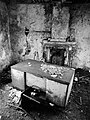
 Desk drawer in the dereliction - geograph.org.uk - 6106666.jpg 1,600 × 1,174; 302 KB
-
 Disused mine by the River Tees - geograph.org.uk - 5770668.jpg 640 × 480; 115 KB
-
 Disused mine by the River Tees at Troutbeck Foot - geograph.org.uk - 6202330.jpg 1,024 × 768; 265 KB
-
 Disused mine shaft, Silverband Mine - geograph.org.uk - 6107442.jpg 1,200 × 1,600; 727 KB
-
 Disused tip, Milburn Forest - geograph.org.uk - 1617116.jpg 640 × 480; 113 KB
-
 Dun Fell - geograph.org.uk - 2225074.jpg 3,833 × 2,172; 1.34 MB
-
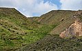 Dun Fell Hush - geograph.org.uk - 2225051.jpg 3,888 × 2,438; 1.66 MB
-
 Dunfell Hush (disused) - geograph.org.uk - 6203279.jpg 1,024 × 768; 344 KB
-
 Dunfell Hush, Great Dun Fell - geograph.org.uk - 4694508.jpg 1,600 × 1,065; 720 KB
-
 Dunfell Hush, Great Dun Fell - geograph.org.uk - 4694513.jpg 1,600 × 1,065; 674 KB
-
 Dunfell Hush, Milburn - geograph.org.uk - 4341817.jpg 640 × 480; 171 KB
-
 Dunfell Mine (disused) - geograph.org.uk - 6203280.jpg 1,024 × 768; 285 KB
-
 Eller Gill - geograph.org.uk - 417614.jpg 640 × 480; 71 KB
-
 Eller Gill, Milburn - geograph.org.uk - 4340700.jpg 640 × 480; 225 KB
-
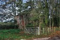
 Entrance to Kirk House - geograph.org.uk - 2118568.jpg 640 × 480; 154 KB
-
-
 Extra tall snow poles - geograph.org.uk - 5007006.jpg 640 × 480; 260 KB
-
 Fallen fellside pylon - geograph.org.uk - 6107456.jpg 1,200 × 1,600; 478 KB
-
 Fallen pylon, Silverband - geograph.org.uk - 1617131.jpg 640 × 480; 96 KB
-
 Far, far, the mountain peak - geograph.org.uk - 6204455.jpg 1,024 × 768; 244 KB
-
 Farm track leading to Underwood - geograph.org.uk - 4717614.jpg 1,600 × 1,065; 707 KB
-
 Farmland near Lounthwaite - geograph.org.uk - 5841805.jpg 1,024 × 879; 345 KB
-
 Farmland, Milburn - geograph.org.uk - 4296666.jpg 640 × 480; 164 KB
-
 Farmland, Milburn - geograph.org.uk - 4298545.jpg 640 × 480; 168 KB
-
 Fenced areas north on side of Trout Beck. - geograph.org.uk - 4417324.jpg 1,500 × 897; 1.77 MB
-
 Field near Knock village - geograph.org.uk - 4572852.jpg 640 × 480; 454 KB
-
 Field with cattle near Knock village - geograph.org.uk - 4572851.jpg 640 × 480; 434 KB
-
 FieldmapLarge.jpg 3,888 × 2,592; 4.47 MB
-
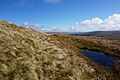
 Flat rocks on moorland west from Hard Hill - geograph.org.uk - 5432742.jpg 1,500 × 936; 1.09 MB
-
 Flood debris beside Middle Tongue Beck - geograph.org.uk - 2183787.jpg 2,000 × 1,379; 2.62 MB
-
 Flooded field by Black Plantation - geograph.org.uk - 1605457.jpg 640 × 480; 103 KB
-
 Flooded workings, Silverband Mine - geograph.org.uk - 1616701.jpg 640 × 480; 74 KB
-
 Following The Tees - geograph.org.uk - 4425576.jpg 4,344 × 2,988; 3.22 MB
-
 Footpath leading to Mill Lane - geograph.org.uk - 4717653.jpg 1,600 × 1,065; 1.11 MB
-

-
 Gated road to Great Dun Fell - geograph.org.uk - 1616673.jpg 640 × 480; 116 KB
-
 George VI postbox at Gullom Holme - geograph.org.uk - 4717667.jpg 1,065 × 1,600; 630 KB
-
 Grassy moorland south-west of Little Dun Fell - geograph.org.uk - 2183521.jpg 2,000 × 1,123; 1.46 MB
-
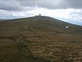
 Great Dun Fell - geograph.org.uk - 1936442.jpg 3,849 × 2,535; 1.11 MB
-
 Great Dun Fell - geograph.org.uk - 2225230.jpg 3,869 × 2,292; 963 KB
-
 Great Dun Fell access road at Castle Green - geograph.org.uk - 6107531.jpg 1,600 × 1,200; 580 KB
-
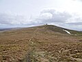 Great Dun Fell from Little Dun Fell - geograph.org.uk - 6106745.jpg 1,600 × 1,200; 510 KB
-
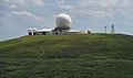
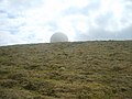
 Great Dun Fell Radar-Comms Station - geograph.org.uk - 6106650.jpg 1,600 × 1,200; 459 KB
-
 Great Dun Fell Radar-Comms Station - geograph.org.uk - 6180353.jpg 4,241 × 2,730; 3.92 MB
-
 Great Dun Fell towards Dunfell Hush - geograph.org.uk - 4694487.jpg 1,600 × 1,065; 649 KB
-
 Hard Hill - geograph.org.uk - 5769656.jpg 640 × 480; 97 KB
-
 Hard Hill - geograph.org.uk - 5769660.jpg 640 × 480; 91 KB
-
 Hard Hills Trig pillar - geograph.org.uk - 1616644.jpg 640 × 480; 89 KB
-
 Hardhill Hush - geograph.org.uk - 5433151.jpg 1,500 × 849; 1.01 MB
-
 Hardhill Hush - geograph.org.uk - 5769662.jpg 640 × 480; 106 KB
-
 Head of Dun Fell Hush - geograph.org.uk - 5433044.jpg 1,500 × 1,125; 1.48 MB
-
 Head of the public road at Green Castle - geograph.org.uk - 5006672.jpg 640 × 480; 254 KB
-
 Heading down the fellside - geograph.org.uk - 6107487.jpg 1,600 × 1,200; 759 KB
-
 Helm Wind Walk at Dunfell Hush, Great Dun Fell - geograph.org.uk - 4694517.jpg 1,600 × 1,065; 650 KB
-
 Helm Wind Walk at Dunfell Hush, Great Dun Fell - geograph.org.uk - 4694523.jpg 1,600 × 1,065; 647 KB
-
 Helm Wind Walk at Dunfell Hush, Great Dun Fell - geograph.org.uk - 4694526.jpg 1,600 × 1,065; 576 KB
-
 Helm Wind Walk follows Trout Beck - geograph.org.uk - 4694837.jpg 1,600 × 1,065; 1.13 MB
-
 Helm Wind Walk follows Trout Beck - geograph.org.uk - 4694844.jpg 1,600 × 1,065; 869 KB
-
 Helm Wind Walk follows Trout Beck - geograph.org.uk - 4694848.jpg 1,600 × 1,065; 787 KB
-
 Helm Wind Walk follows Trout Beck - geograph.org.uk - 4694867.jpg 1,600 × 1,065; 821 KB
-
 Helm Wind Walk follows Trout Beck - geograph.org.uk - 4694969.jpg 1,600 × 1,065; 761 KB
-
 Helm Wind Walk near Dunfell Mine - geograph.org.uk - 4694603.jpg 1,600 × 1,065; 584 KB
-
 Helm Wind Walk near Dunfell Mine - geograph.org.uk - 4694605.jpg 1,600 × 1,065; 625 KB
-
 Helm Wind Walk on Moor House - geograph.org.uk - 4694608.jpg 1,600 × 1,065; 663 KB
-
 Helm Wind Walk on Moor House - geograph.org.uk - 4694633.jpg 1,600 × 1,065; 769 KB
-
 Helm Wind Walk on Moor House - geograph.org.uk - 4694636.jpg 1,600 × 1,065; 964 KB
-
 Helm Wind Walk on Moor House - geograph.org.uk - 4694645.jpg 1,600 × 1,065; 1.08 MB
-
 Helm Wind Walk on Moor House - geograph.org.uk - 4694648.jpg 1,600 × 1,065; 679 KB
-
 Helm Wind Walk on Moor House - geograph.org.uk - 4694651.jpg 1,600 × 1,065; 730 KB
-
 Helm Wind Walk on Moor House - geograph.org.uk - 4694673.jpg 1,600 × 1,065; 805 KB
-
 Helm Wind Walk on Moor House, Moor - geograph.org.uk - 4694725.jpg 1,600 × 1,065; 578 KB
-
 Helm Wind Walk on Moor House, Moor - geograph.org.uk - 4694730.jpg 1,600 × 1,065; 564 KB
-
 Helm Wind Walk on Moor House, Moor - geograph.org.uk - 4694735.jpg 1,600 × 1,065; 844 KB
-
 Helm Wind Walk on Moor House, Moor - geograph.org.uk - 4694737.jpg 1,600 × 1,065; 586 KB
-
 Helm Wind Walk on Moor House, Moor - geograph.org.uk - 4694762.jpg 1,600 × 1,065; 657 KB
-
 Helm Wind Walk on Moor House, Moor - geograph.org.uk - 4694765.jpg 1,600 × 1,065; 607 KB
-
 Helm Wind Walk on Moor House, Moor - geograph.org.uk - 4694769.jpg 1,600 × 1,065; 609 KB
-
 Helm Wind Walk on Moor House, Moor - geograph.org.uk - 4694894.jpg 1,600 × 1,065; 702 KB
-
 Helm Wind Walk on Moor House, Moor - geograph.org.uk - 4694899.jpg 1,600 × 1,065; 746 KB
-
 Helm Wind Walk on Moor House, Moor - geograph.org.uk - 4694913.jpg 1,600 × 1,065; 667 KB
-
 Helm Wind Walk on Moor House, Moor - geograph.org.uk - 4694918.jpg 1,600 × 1,065; 776 KB
-
 Helm Wind Walk on Moor House, Moor - geograph.org.uk - 4694980.jpg 1,600 × 1,065; 1.08 MB
-
 Helm Wind Walk on Moor House, Moor - geograph.org.uk - 4695034.jpg 1,600 × 1,065; 537 KB
-
 Helm Wind Walk on Moor House, Moor - geograph.org.uk - 4695054.jpg 1,600 × 1,065; 801 KB
-
 Helm Wind Walk towards Trout Beck - geograph.org.uk - 4694671.jpg 1,600 × 1,065; 605 KB
-
 Helm Wind Walk towards Troutbeck Foot - geograph.org.uk - 4708876.jpg 1,600 × 1,065; 652 KB
-
 Helm Wind Walk towards Troutbeck Foot - geograph.org.uk - 4708891.jpg 1,600 × 1,065; 612 KB
-
 Houses at Gullom Holme near Milburn - geograph.org.uk - 4717663.jpg 1,600 × 1,065; 744 KB
-
 Houses on The Green at Milburn - geograph.org.uk - 5899324.jpg 4,000 × 3,000; 4.81 MB
-
 Hush above Swathbeck Mine - geograph.org.uk - 5769641.jpg 640 × 480; 103 KB
-
 Information board on Moor House, Upper Teesdale - geograph.org.uk - 4708905.jpg 1,600 × 1,453; 914 KB
-
 Knock Ore Gill - geograph.org.uk - 1856517.jpg 480 × 640; 81 KB
-
 Knock Ore Gill - geograph.org.uk - 1856520.jpg 480 × 640; 78 KB
-
 Leaving Little Dun Fell - geograph.org.uk - 4693797.jpg 1,600 × 1,065; 687 KB
-
 Little Dun Fell - geograph.org.uk - 2225219.jpg 3,821 × 2,296; 1.11 MB
-
 Little Dun Fell - geograph.org.uk - 2225236.jpg 3,888 × 2,325; 1.62 MB
-
 Little Dun Fell, Milburn - geograph.org.uk - 4341828.jpg 640 × 480; 180 KB
-
 Looking down The Green at Milburn - geograph.org.uk - 5899328.jpg 4,000 × 3,000; 4.73 MB
-
 Looking north from Little Dun Fell - geograph.org.uk - 4693739.jpg 1,600 × 1,065; 573 KB
-
 Looking over Knock Ore Gill - geograph.org.uk - 1856514.jpg 640 × 480; 76 KB
-
 Looking towards Cross Fell from Little Dun Fell - geograph.org.uk - 4693728.jpg 1,600 × 1,065; 656 KB
-
 Looking towards Great Dun Fell from Little Dun Fell - geograph.org.uk - 4693751.jpg 1,600 × 1,065; 749 KB
-
 Looking towards Great Dun Fell from Little Dun Fell - geograph.org.uk - 4693753.jpg 1,600 × 1,065; 557 KB
-
 Looking towards Little Dun Fell - geograph.org.uk - 4694435.jpg 1,600 × 1,065; 600 KB
-
 Lounthwaite - geograph.org.uk - 2697419.jpg 3,888 × 2,456; 1.35 MB
-
 Masts on Great Dun Fell - geograph.org.uk - 6106640.jpg 1,200 × 1,600; 252 KB
-
 Maypole, Milburn - geograph.org.uk - 290516.jpg 640 × 461; 57 KB
-
 Middle Tongue Beck - geograph.org.uk - 1856861.jpg 480 × 640; 85 KB
-
 Middle Tongue Beck - geograph.org.uk - 1856867.jpg 640 × 480; 67 KB
-
 Milburn - geograph.org.uk - 2697239.jpg 3,805 × 2,469; 1.51 MB
-
 Milburn Beck - geograph.org.uk - 2390071.jpg 640 × 480; 144 KB
-
 Milburn Forest - geograph.org.uk - 2225093.jpg 3,888 × 2,350; 2.06 MB
-
 Milburn Forest - geograph.org.uk - 6203276.jpg 1,024 × 768; 173 KB
-
 Milburn Grange Ford - geograph.org.uk - 5719587.jpg 4,032 × 3,024; 2.29 MB
-
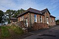 Milburn Village Hall - geograph.org.uk - 4717650.jpg 1,600 × 1,065; 692 KB
-
 Milburn, Cumbria - geograph.org.uk - 74119.jpg 640 × 480; 117 KB
-
 MilburnVillageCumbria(SimonLedingham)Oct2003.jpg 640 × 480; 175 KB
-
 Mine ruin, Milburn - geograph.org.uk - 4340692.jpg 640 × 480; 160 KB
-
 Mine shaft, Swarth Beck - geograph.org.uk - 1617126.jpg 640 × 480; 110 KB
-
 Mine site beside Middle Tongue Beck - geograph.org.uk - 2183753.jpg 2,000 × 1,500; 2.75 MB
-
 Minor tributary of Trout Beck - geograph.org.uk - 5770651.jpg 640 × 480; 117 KB
-
 Moor House - Upper Teesdale - geograph.org.uk - 4693673.jpg 1,600 × 1,065; 588 KB
-
 Moorland above the Silverband Mine (disused) - geograph.org.uk - 6203277.jpg 1,024 × 768; 313 KB
-
 Moorland above the Silverband Mine (disused) - geograph.org.uk - 6203278.jpg 1,024 × 768; 299 KB
-
 Moorland below the summit of Great Dun Fell - geograph.org.uk - 6107542.jpg 1,600 × 1,200; 529 KB
-
 Moorland, Milburn - geograph.org.uk - 4340526.jpg 640 × 480; 162 KB
-
 Moorland, Milburn - geograph.org.uk - 4341848.jpg 640 × 480; 171 KB
-
 Moorland, Milburn - geograph.org.uk - 4341962.jpg 640 × 480; 197 KB
-
 Moorland, Milburn - geograph.org.uk - 4342033.jpg 640 × 480; 183 KB
-
 Moorland, Milburn - geograph.org.uk - 4342041.jpg 640 × 480; 198 KB
-
 Moorland, Milburn Forest - geograph.org.uk - 1617121.jpg 640 × 480; 130 KB
-
 Moorland, Moor House Nature Reserve - geograph.org.uk - 1617111.jpg 640 × 480; 111 KB
-
 Mudgill Sike - geograph.org.uk - 2183162.jpg 2,000 × 1,500; 2.16 MB
-
 Mudgill Sike - geograph.org.uk - 417549.jpg 640 × 480; 83 KB
-
 Mudgill Sike, Milburn - geograph.org.uk - 4340431.jpg 640 × 427; 172 KB
-
 NATS access road on Great Dun Fell - geograph.org.uk - 4694470.jpg 1,600 × 1,065; 579 KB
-
 NATS Radar - Comms Station on Great Dun Fell - geograph.org.uk - 4693795.jpg 1,600 × 1,065; 543 KB
-
 NATS Radar - Comms Station on Great Dun Fell - geograph.org.uk - 4694454.jpg 1,600 × 1,065; 506 KB
-
 NATS Radar - Comms Station on Great Dun Fell - geograph.org.uk - 4694457.jpg 1,600 × 1,065; 553 KB
-
 NATS Radar - Comms Station on Great Dun Fell - geograph.org.uk - 4694466.jpg 1,600 × 1,065; 589 KB
-

-
 Near Gullom Holme - geograph.org.uk - 3651485.jpg 3,726 × 2,160; 2.28 MB
-
 Near Newbiggin Moor (2) - geograph.org.uk - 3651498.jpg 4,320 × 3,240; 5.73 MB
-
 Near Newbiggin Moor - geograph.org.uk - 3651492.jpg 4,320 × 3,240; 4.94 MB
-
 Newbiggin Mill - geograph.org.uk - 2697469.jpg 3,888 × 2,592; 3.42 MB
-
 Old mine tip by Trout Beck - geograph.org.uk - 6204441.jpg 1,024 × 768; 294 KB
-
 On Great Dun Fell - geograph.org.uk - 1856555.jpg 640 × 480; 57 KB
-
 On Great Dun Fell - geograph.org.uk - 1856558.jpg 640 × 480; 70 KB
-
 On Little Dun Fell - geograph.org.uk - 1856560.jpg 640 × 480; 54 KB
-
 On Little Dun Fell - geograph.org.uk - 1856562.jpg 640 × 480; 62 KB
-
 On Little Dun Fell - geograph.org.uk - 1856565.jpg 640 × 480; 56 KB
-
 On Silver Band - geograph.org.uk - 1856954.jpg 640 × 480; 76 KB
-
 Outside the office, Silverband Mine - geograph.org.uk - 6106674.jpg 1,200 × 1,600; 583 KB
-
 Pasture and woodland, Milburn - geograph.org.uk - 4338173.jpg 640 × 480; 216 KB
-
 Pasture east of Milburn - geograph.org.uk - 2183824.jpg 2,000 × 1,123; 1.66 MB
-
 Pastures, Milburn - geograph.org.uk - 4340447.jpg 640 × 480; 166 KB
-
 Path alongside Trout Beck - geograph.org.uk - 4418949.jpg 1,500 × 1,125; 1.46 MB
-
 Path junction on Great Dun Fell - geograph.org.uk - 5007010.jpg 640 × 480; 249 KB
-
 Peat haggs on Knock Fell - geograph.org.uk - 6203274.jpg 1,024 × 768; 255 KB
-
 Pennine Way at Crowdundle Head - geograph.org.uk - 4693680.jpg 1,600 × 1,065; 579 KB
-
 Pennine Way at Crowdundle Head - geograph.org.uk - 4693690.jpg 1,600 × 1,065; 675 KB
-
 Pennine Way at Dunfell Hush - geograph.org.uk - 4694490.jpg 1,600 × 1,065; 889 KB
-
 Pennine Way at Dunfell Hush - geograph.org.uk - 4694496.jpg 1,600 × 1,065; 785 KB
-
 Pennine Way at Great Dun Fell - geograph.org.uk - 4694453.jpg 1,600 × 1,065; 873 KB
-
 Pennine Way near Dunfell Hush - geograph.org.uk - 4694489.jpg 1,600 × 1,065; 709 KB
-
 Pennine Way sign - geograph.org.uk - 5197472.jpg 800 × 534; 62 KB
-
 Pennine Way towards Great Dun Fell - geograph.org.uk - 4694394.jpg 1,600 × 1,065; 623 KB
-
 Pennine Way towards Great Dun Fell - geograph.org.uk - 4694406.jpg 1,600 × 1,065; 730 KB
-
 Pennine Way towards Great Dun Fell - geograph.org.uk - 4694413.jpg 1,600 × 1,065; 668 KB
-
 Pennine Way towards Little Dun Fell - geograph.org.uk - 4693547.jpg 1,600 × 1,065; 638 KB
-
 Pennine Way towards Little Dun Fell - geograph.org.uk - 4693563.jpg 1,600 × 1,065; 393 KB
-
 Pennine Way towards Little Dun Fell - geograph.org.uk - 4693683.jpg 1,600 × 1,065; 658 KB
_-_geograph.org.uk_-_5007007.jpg)
_-_geograph.org.uk_-_5007013.jpg)
_-_geograph.org.uk_-_5007017.jpg)


_-_geograph.org.uk_-_6203279.jpg)


_-_geograph.org.uk_-_6203280.jpg)


_-_geograph.org.uk_-_6203277.jpg)
_-_geograph.org.uk_-_6203278.jpg)


_-_geograph.org.uk_-_3651498.jpg)


