Category:May 2007 in London
Jump to navigation
Jump to search
Deutsch: Bilder, die im Mai 2007 in London aufgenommen worden sind. Bitte beachten Sie, dass dies weder das Datum des Uploads noch das Datum des Scannens eines Fotos ist.
English: Images/pictures taken in London during May 2007. Note this is not the date of the upload, nor the date a photo was scanned.
Español: Fotografías o imágenes tomadas en London durante mayo 2007. No es la fecha de subida ni escaneo, sino la fecha en que las fotografías o imágenes se crearon.
Esperanto: Bildoj faritaj en London en majo 2007. Tio ne estas la dato, kiam la bildoj estis alŝutitaj aŭ skanitaj.
Français : Photographies ou images prises en London durant mai 2007. Ce n'est pas la date du téléchargement ou du scan.
Galego: Fotografías ou imaxes tomadas en London durante maio 2007. Non é a data de subida nin escaneamento, senón a data na que se crearon as fotografías ou imaxes.
Italiano: Fotografie o immagini scattate a London nel maggio 2007. Nota bene: la data non si riferisce né a quella di upload né a quella in cui la foto è stata digitalizzata.
Norsk bokmål: Bilder tatt i London i løpet av mai 2007. Merk at dette ikke er datoen for opplasting, eller når et bilde har blitt skannet.
Norsk nynorsk: Bilete teke i London i løpet av mai 2007. Merk at dette ikkje er datoen for opplasting, eller når eit bilete har vorte skanna.
Русский: Изображения, сделанные в London в течение май 2007 (не дата загрузки изображения).
Українська: Зображення, зроблені в London протягом травень 2007. Зауважте, що це не дата завантаження чи дата сканування фотографії.
| May 2006 | ← | May 2007 | → | May 2008 | |||||||
| Jan | Feb | Mar | Apr | May | Jun | Jul | Aug | Sep | Oct | Nov | Dec |
| 230 | 268 | 56 | 438 | 274 | 271 | 353 | 370 | 212 | 534 | 362 | 417 |
|---|---|---|---|---|---|---|---|---|---|---|---|
Subcategories
This category has the following 22 subcategories, out of 22 total.
Media in category "May 2007 in London"
The following 200 files are in this category, out of 252 total.
(previous page) (next page)-
 90036 British Rail double arrow.jpg 3,648 × 2,736; 3.55 MB
-
 Oyster southern ticket office2.jpg 640 × 480; 24 KB
-
 ScotRail Mk2 coach at Euston.jpg 3,648 × 2,736; 4.01 MB
-
 90035 at Euston.jpg 3,648 × 2,736; 4.35 MB
-
 Warren Street Station and BT Tower.jpg 3,648 × 2,736; 3.92 MB
-
 39 Frognal.jpg 2,100 × 1,680; 853 KB
-
 A205 South Circular Road at Forest Hill - geograph.org.uk - 437063.jpg 640 × 480; 117 KB
-
 Addison Way - geograph.org.uk - 444593.jpg 640 × 480; 130 KB
-
 Air New Zealand Boeing 777-200ER Lofting-1.jpg 1,280 × 847; 621 KB
-
 Air New Zealand Boeing 777-200ER Lofting-2.jpg 1,280 × 847; 606 KB
-
 Air New Zealand Boeing 777-200ER Lofting-3.jpg 1,280 × 847; 528 KB
-
 Albert Bridge - geograph.org.uk - 2010212.jpg 1,024 × 768; 106 KB
-
-

-
 All Saints church Benhilton - window - geograph.org.uk - 1037895.jpg 428 × 606; 384 KB
-

-
-
 All Saints church Carshalton - organ - geograph.org.uk - 1037839.jpg 640 × 480; 96 KB
-

-
 ANA Boeing 747-400 Lofting.jpg 1,280 × 849; 501 KB
-
 Asda, East Beckton Centre - geograph.org.uk - 450575.jpg 640 × 480; 146 KB
-
 BAe146 aircraft from A Flight of 32 (The Royal) Squadron MOD 45147911.jpg 3,000 × 2,250; 3.81 MB
-
 Barry Road, SE22 - geograph.org.uk - 451447.jpg 640 × 480; 128 KB
-
 Belleville primary school.jpg 226 × 340; 24 KB
-
 Beresford Street, SE18 - geograph.org.uk - 463990.jpg 640 × 480; 64 KB
-
-
 Blythe Hill Fields, Forest Hill - geograph.org.uk - 437054.jpg 640 × 480; 98 KB
-
 Bow Creek Ecology Park, Canning Town - geograph.org.uk - 441269.jpg 640 × 480; 106 KB
-
 Bow Police Station, Bow Road - geograph.org.uk - 433879.jpg 640 × 480; 123 KB
-
 British Airways Boeing 747-400 Lofting-4.jpg 1,280 × 849; 559 KB
-
-
 Brixton Overground Station - geograph.org.uk - 422469.jpg 640 × 480; 109 KB
-
 BussesLONDon.jpg 1,280 × 960; 309 KB
-
 Cable Bearers - geograph.org.uk - 443473.jpg 430 × 640; 161 KB
-
 Canning Town Station - geograph.org.uk - 441856.jpg 640 × 480; 119 KB
-

-
 Ceiling in the Upper Link Room.jpg 2,560 × 1,920; 1.03 MB
-
 Chanctonbury Way - geograph.org.uk - 453615.jpg 640 × 480; 155 KB
-
 Channel 4 Horseferry Road London (512614460).jpg 1,280 × 495; 112 KB
-
 Cheval Place, SW7 - geograph.org.uk - 445793.jpg 640 × 480; 116 KB
-
 Click A320 (523505222).jpg 2,048 × 1,536; 831 KB
-
 College Farm - geograph.org.uk - 444603.jpg 640 × 480; 155 KB
-
 Concorde G-BOAB (520085850).jpg 2,048 × 1,536; 824 KB
-
 Contrast (524744355).jpg 2,000 × 3,008; 1.51 MB
-
 Cork oak tree, Osterley House Grounds - geograph.org.uk - 571640.jpg 640 × 480; 183 KB
-

-

-
 Corporation Street, E15 - geograph.org.uk - 453601.jpg 640 × 480; 136 KB
-
 Cowcross Street, Farringdon - geograph.org.uk - 443747.jpg 640 × 480; 114 KB
-
 Dagenham Brook.JPG 640 × 480; 140 KB
-
 Deansway - geograph.org.uk - 441387.jpg 640 × 480; 114 KB
-
 Deptford Green - geograph.org.uk - 462239.jpg 640 × 480; 97 KB
-
 Doran Manor and Linksview - geograph.org.uk - 441421.jpg 640 × 480; 90 KB
-
 Earls Court 2.jpg 1,024 × 681; 304 KB
-
 Edinboro Castle Gastropub - geograph.org.uk - 566264.jpg 640 × 480; 95 KB
-
 Etchingham Park Road - geograph.org.uk - 448975.jpg 640 × 392; 76 KB
-
 Euston Road - geograph.org.uk - 443755.jpg 640 × 480; 104 KB
-
 Exchange Square, near Harbour Island - geograph.org.uk - 438625.jpg 480 × 640; 88 KB
-
 Farmers' Market in Acton - geograph.org.uk - 442335.jpg 640 × 480; 120 KB
-
 Flyover next to the River Roding - geograph.org.uk - 432779.jpg 640 × 480; 126 KB
-
 Food Court at Elephant and Castle - geograph.org.uk - 427827.jpg 640 × 480; 141 KB
-
 Forest Croft 040.jpg 2,048 × 1,536; 751 KB
-
 Forest Gate Station.jpg 640 × 480; 99 KB
-
 Foyer of Sadlers Wells Theatre - geograph.org.uk - 428426.jpg 480 × 640; 196 KB
-
 Gargoyle at the British Natural History Museum.jpg 1,024 × 768; 137 KB
-
 Geffrye Herbarium.jpg 960 × 1,280; 375 KB
-
 Going into Service - geograph.org.uk - 441437.jpg 640 × 441; 153 KB
-
 Golders Green Cemetery - geograph.org.uk - 825391.jpg 640 × 480; 97 KB
-
 Golders Green Cemetery - geograph.org.uk - 825397.jpg 640 × 480; 60 KB
-
 Green and White Statue in Jubilee Park - geograph.org.uk - 440258.jpg 640 × 480; 160 KB
-
 Green Street Millennium Pavement - geograph.org.uk - 445553.jpg 640 × 480; 149 KB
-
 Green Street, E7 - geograph.org.uk - 433312.jpg 640 × 480; 113 KB
-
 Hammersmith Terrace - geograph.org.uk - 425554.jpg 640 × 480; 133 KB
-
 Hammersmith Terrace from Black Lion Lane - geograph.org.uk - 425552.jpg 640 × 480; 110 KB
-

-

-
 Heath Strange Garden - geograph.org.uk - 455526.jpg 640 × 480; 119 KB
-
 Henley Road, Ilford - geograph.org.uk - 432772.jpg 640 × 480; 101 KB
-
 Highgate Depot.jpg 640 × 489; 169 KB
-
 Holland Road, E15 - geograph.org.uk - 448176.jpg 640 × 480; 107 KB
-
 Horses in Hampstead - geograph.org.uk - 433917.jpg 640 × 480; 99 KB
-
 Houses of Parliament, SW1 - geograph.org.uk - 2008838.jpg 1,024 × 768; 73 KB
-
 Houses on Holland Park, W11 - geograph.org.uk - 425702.jpg 640 × 480; 137 KB
-
 Houses on Waldram Park Road - geograph.org.uk - 437070.jpg 640 × 480; 151 KB
-
 Ilford Lane, near Henley Road. - geograph.org.uk - 432769.jpg 640 × 480; 101 KB
-
 Inside Senate House.jpg 3,212 × 2,442; 622 KB
-
 Inside the Monument, EC3 - geograph.org.uk - 2039589.jpg 768 × 1,024; 114 KB
-

-
 Iran Air Boeing 747SP Lofting-2.jpg 1,280 × 849; 479 KB
-
 Islington Chapel.jpg 1,200 × 1,600; 489 KB
-

-
 Italian Garden, Gunnersbury Park - geograph.org.uk - 420628.jpg 640 × 480; 160 KB
-
 Jubilee Line Depot, West Ham - geograph.org.uk - 445299.jpg 640 × 480; 93 KB
-
 Kenley Common - geograph.org.uk - 1767250.jpg 800 × 488; 129 KB
-
 King George V Dock and Beyond - geograph.org.uk - 450556.jpg 640 × 480; 85 KB
-
 Leadenhall Market, 24 May 2007.jpg 2,000 × 2,785; 2.31 MB
-
 Lethbridge Close, SE13 - geograph.org.uk - 437282.jpg 640 × 480; 120 KB
-

-
 Lewisham Station (1) - geograph.org.uk - 436670.jpg 640 × 480; 114 KB
-
 Lewisham Station (2) - geograph.org.uk - 436678.jpg 640 × 480; 97 KB
-
 Lewisham Station, platforms 1 and 2 - geograph.org.uk - 436694.jpg 640 × 480; 106 KB
-
 Lewisham Station, platforms 3 and 4 - geograph.org.uk - 436684.jpg 640 × 480; 127 KB
-
 Leyton Orient Football Club - geograph.org.uk - 422836.jpg 640 × 480; 75 KB
-
 Lifebuoy-Thames.jpg 1,724 × 1,572; 1.32 MB
-
 Lindsey Street, Smithfield - geograph.org.uk - 443556.jpg 640 × 480; 120 KB
-
 London , Waterloo Railway Station - geograph.org.uk - 1139814.jpg 640 × 480; 67 KB
-
 London , Waterloo Railway Station - geograph.org.uk - 1139815.jpg 640 × 480; 66 KB
-
 London - Orange Shop.jpg 1,127 × 1,519; 184 KB
-
 London Bus route 12.jpg 3,648 × 2,736; 3.97 MB
-
 London Bus route 148.jpg 3,648 × 2,736; 4.12 MB
-
 London stock exchange reclad 3.jpg 900 × 506; 503 KB
-
 London stock exchange reclad 4.jpg 600 × 800; 86 KB
-
 London, UK. (27972280121).jpg 4,000 × 3,000; 4.63 MB
-
 London, UK. (27972282101).jpg 4,000 × 3,000; 4.91 MB
-
 London, UK. (28015140026).jpg 3,932 × 2,949; 3.82 MB
-
 Love Lane, EC2 - geograph.org.uk - 827480.jpg 640 × 480; 109 KB
-
 Loving Boobs (1444629872).jpg 3,008 × 2,000; 2.43 MB
-
 Lyttelton Road - geograph.org.uk - 438840.jpg 640 × 480; 116 KB
-
 Lyttleton Playing Fields - geograph.org.uk - 438855.jpg 480 × 640; 133 KB
-
 Main Entrance, Exchange Tower - geograph.org.uk - 438628.jpg 640 × 480; 134 KB
-
 Main Road, Gidea Park in 2007.jpg 640 × 493; 82 KB
-
 Manor Park Cemetery - geograph.org.uk - 1297173.jpg 640 × 480; 65 KB
-
 Mansion House, EC4 - geograph.org.uk - 2016215.jpg 1,024 × 768; 177 KB
-
 Market Place, N2.JPG 3,264 × 2,448; 3.14 MB
-
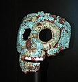 Mask of Quetzalcoatl at the British Museum 001.jpg 2,590 × 2,705; 3.78 MB
-
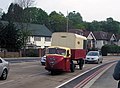 Mechanical Horse - geograph.org.uk - 877539.jpg 640 × 472; 96 KB
-
 Millbank Tower, Thames House, Parliament.JPG 3,264 × 2,448; 3.02 MB
-
 Monument stairwell.JPG 3,008 × 2,000; 3 MB
-
 Mornington Terrace - geograph.org.uk - 441598.jpg 640 × 480; 97 KB
-
 Mount Street, London W1K - geograph.org.uk - 1109710.jpg 640 × 360; 78 KB
-
 Muswell Hill Road Bridge - geograph.org.uk - 443458.jpg 480 × 640; 134 KB
-
 Mutton Brook - geograph.org.uk - 438868.jpg 480 × 640; 199 KB
-
 Natal Road, Ilford - geograph.org.uk - 432764.jpg 640 × 480; 121 KB
-

-

-

-
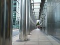
 North Colonnade, E14 - geograph.org.uk - 438651.jpg 640 × 480; 86 KB
-
 North London Line, Highbury and Islington - geograph.org.uk - 453907.jpg 639 × 480; 123 KB
-
 North Woolwich Station, closed - geograph.org.uk - 450258.jpg 640 × 480; 117 KB
-
 Northwood Tube.JPG 3,008 × 2,000; 2.27 MB
-
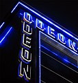 Odeon Leicester Square Lighting.jpg 1,006 × 1,056; 176 KB
-
 Orchard Estate, Lewisham (1) - geograph.org.uk - 437294.jpg 640 × 480; 120 KB
-
 Oswin Street, SE1 - geograph.org.uk - 427831.jpg 640 × 480; 132 KB
-
 Oxford Street near Marble Arch - geograph.org.uk - 425741.jpg 640 × 480; 124 KB
-
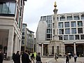 Paternoster Square Column - geograph.org.uk - 550607.jpg 640 × 480; 91 KB
-
 Path between Asda and Beckton Station - geograph.org.uk - 450572.jpg 640 × 480; 137 KB
-
 Patti Smith performing at Roundhouse, London (4).jpg 2,592 × 3,456; 786 KB
-

-
-

-
 PBridgePillbox.JPG 3,264 × 2,448; 3.16 MB
-
 Pensbury Place, SW8 - geograph.org.uk - 421994.jpg 640 × 480; 91 KB
-

-
 Pete Evil.jpg 2,592 × 3,888; 1.82 MB
-
 Piccadilly Circus - geograph.org.uk - 725696.jpg 640 × 480; 85 KB
-
 Pier, North Woolwich - geograph.org.uk - 450238.jpg 640 × 480; 129 KB
-
 Pigeons on the Pavement, Green St - geograph.org.uk - 433868.jpg 640 × 480; 165 KB
-
 Pipes and Half a Gasometer, Beckton - geograph.org.uk - 452427.jpg 640 × 480; 104 KB
-
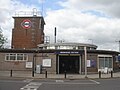
 Plaistow Station - geograph.org.uk - 448181.jpg 640 × 480; 98 KB
-
 Popes Road Market, Brixton - geograph.org.uk - 422468.jpg 640 × 480; 133 KB
-
 Porden Road, SW2 - geograph.org.uk - 430390.jpg 640 × 480; 120 KB
-
 Power cable joint bay - geograph.org.uk - 420812.jpg 640 × 480; 142 KB
-
 Queen Victoria Pub - geograph.org.uk - 488291.jpg 640 × 480; 101 KB
-
 Queensbury Methodist Church - geograph.org.uk - 441678.jpg 640 × 480; 107 KB
-
 Queensbury, All Saints Church - geograph.org.uk - 441664.jpg 640 × 480; 121 KB
-
 Railway Lines and Industry, Nine Elms - geograph.org.uk - 421983.jpg 640 × 480; 124 KB
-
 Rain at Greenwich, London.jpg 3,022 × 2,159; 1.68 MB
-
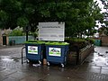 Recycling Site, Audrey Road, Ilford - geograph.org.uk - 432773.jpg 640 × 480; 127 KB
-
 Redbridge Tube Station2.jpg 2,048 × 1,536; 1.37 MB
-

-
 Road to Nowhere (523041471).jpg 2,615 × 1,447; 2.17 MB
-
 Rockingham Community Day Nursery - geograph.org.uk - 431577.jpg 640 × 480; 98 KB
-
 Romford Road near Dersingham Avenue, E12 - geograph.org.uk - 432784.jpg 640 × 480; 108 KB
-
 Rope Yard Rails, SE18 - geograph.org.uk - 463986.jpg 640 × 480; 111 KB
-

-
 Roxborough Road - geograph.org.uk - 441138.jpg 640 × 480; 96 KB
-
 Roxborough Road - geograph.org.uk - 441140.jpg 640 × 480; 98 KB
-
 Royal Naval College, Greenwich (1) - geograph.org.uk - 597211.jpg 640 × 383; 60 KB
-
 Royal Naval College, Greenwich (2) - geograph.org.uk - 597218.jpg 452 × 640; 67 KB
-
 Royal Naval College, Greenwich (3) - geograph.org.uk - 597227.jpg 640 × 599; 72 KB
-
 Royal Naval College, Greenwich (4) - geograph.org.uk - 597236.jpg 640 × 380; 44 KB
-
 Royal Naval College, Greenwich (5) - geograph.org.uk - 597246.jpg 481 × 640; 63 KB
-
 Royal Naval College, Greenwich (6) - geograph.org.uk - 597249.jpg 640 × 368; 42 KB
-
 Rutland Street, SW7 - geograph.org.uk - 445805.jpg 640 × 480; 97 KB
-
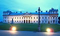
 Selsdon Park Hotel, Selsdon - geograph.org.uk - 446795.jpg 640 × 480; 111 KB
-

-

-
 Shops on Green Street, E7 - geograph.org.uk - 433296.jpg 640 × 480; 129 KB
-

-
 Silvertown Way, E16 - geograph.org.uk - 441868.jpg 640 × 480; 105 KB
-
 Sir Steve Redgrave Bridge - geograph.org.uk - 450560.jpg 640 × 480; 54 KB
-

-
 Site of the former Hornchurch bus garage - geograph.org.uk - 441378.jpg 640 × 539; 100 KB
-
 Skate Park from the Grand Union Canal - geograph.org.uk - 442304.jpg 640 × 480; 95 KB
-
 Square-about - geograph.org.uk - 449112.jpg 640 × 480; 122 KB
-
 Sri Mahalahshmi Temple, East Ham - geograph.org.uk - 452526.jpg 640 × 480; 89 KB
-
 St Giles' in the Barbican - geograph.org.uk - 432797.jpg 640 × 491; 89 KB
-
 St-Dunstans-College.JPG 1,997 × 1,508; 1.1 MB
-
 Statue Of Queen Victoria-Blackfriars Bridge-London.JPG 685 × 800; 246 KB
-


_Squadron_MOD_45147911.jpg)


.jpg)

.jpg)
.jpg)


_-_geograph.org.uk_-_436670.jpg)
_-_geograph.org.uk_-_436678.jpg)


.jpg)
.jpg)
.jpg)

.jpg)


_-_geograph.org.uk_-_437294.jpg)


.jpg)


.jpg)


_-_geograph.org.uk_-_597211.jpg)
_-_geograph.org.uk_-_597218.jpg)
_-_geograph.org.uk_-_597227.jpg)
_-_geograph.org.uk_-_597236.jpg)
_-_geograph.org.uk_-_597246.jpg)
_-_geograph.org.uk_-_597249.jpg)


.jpg)