Category:Martinerhof (Trier)
Jump to navigation
Jump to search
Ehemaliges Hofgut der Benediktinerabtei Sankt Martin, Trier-West/Pallien, Stadt Trier Palliener Straße 19
| Object location | | View all coordinates using: OpenStreetMap |
|---|
Media in category "Martinerhof (Trier)"
The following 5 files are in this category, out of 5 total.
-
 Pallien Martinerhof (4).jpg 2,765 × 2,461; 4.42 MB
-
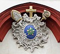
 Pallien St. Martin.jpg 1,544 × 1,411; 1.82 MB
-
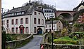
 Trier Pallien Martinerhof.jpg 3,094 × 2,561; 1.69 MB
-
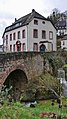
 TrierPallienMartinerhofNapoleonbrueckeH2c.jpg 1,728 × 1,015; 818 KB
-
 TrierPallienMartinerhofSirzenicherBachH1c.jpg 1,080 × 1,920; 1,021 KB
.jpg)


