Category:Marienplatz 7 (Wiesentheid)
Jump to navigation
Jump to search
This is the category of the Bavarian Baudenkmal (cultural heritage monument) with the ID D-6-75-178-26 (Wikidata)
|
| Object location | | View all coordinates using: OpenStreetMap |
|---|
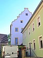
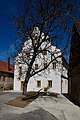
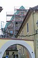
Deutsch: Sogenanntes Templerhaus. Renaissancebau mit geschwungenen Giebeln, erste Hälfte 17. Jahrhundert. Marienplatz 7, Wiesentheid, Landkreis Kitzingen, Unterfranken, Deutschland.
cultural heritage monument D-6-75-178-26 (0) in Wiesentheid, Bavaria | |||||
| Upload media | |||||
| Instance of | |||||
|---|---|---|---|---|---|
| Location | Wiesentheid, Kitzingen, Lower Franconia, Bavaria, Germany | ||||
| Street address |
| ||||
| Heritage designation | |||||
 | |||||
Media in category "Marienplatz 7 (Wiesentheid)"
The following 5 files are in this category, out of 5 total.
-
 1 Templerhaus Wiesentheid 1.jpg 3,089 × 2,592; 3.94 MB
-
 1 Templerhaus Wiesentheid 2.jpg 2,415 × 3,294; 1.21 MB
-
 Marienplatz 7 Wiesentheid 20210426 205.jpg 3,452 × 5,188; 13.71 MB
-
 Marienplatz 7 Wiesentheid 20210426 206.jpg 3,441 × 5,172; 18.17 MB
-
 Wiesentheid, Marienplatz 7-20151228-001.jpg 4,016 × 6,016; 9.06 MB


