Category:Marienkapelle (Würzburg)
Jump to navigation
Jump to search
| Object location | | View all coordinates using: OpenStreetMap |
|---|
cultural heritage monument D-6-63-000-321 (0) in Würzburg, Bavaria  | |||||
| Upload media | |||||
| Instance of | |||||
|---|---|---|---|---|---|
| Named after | |||||
| Location | Würzburg, Lower Franconia, Bavaria, Germany | ||||
| Street address |
| ||||
| Architectural style | |||||
| Diocese | |||||
| Heritage designation | |||||
 | |||||
This is the category of the Bavarian Baudenkmal (cultural heritage monument) with the ID D-6-63-000-321 (Wikidata)
|
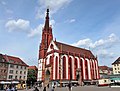
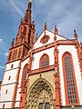
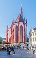
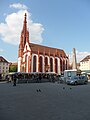
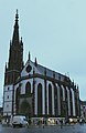
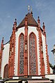
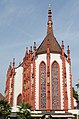
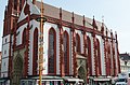
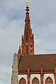
Deutsch: Würzburg - Marienplatz 2 - Marienkapelle. Katholische Pfarrkirche, auf dem Platz der 1349 zerstörten Synagoge errichtete dreischiffige Pfeilerhalle mit langgestrecktem Chor, 5/8-Chorschluss sowie nordwestlichem Turm mit durchbrochenem steinernem Spitzhelm, reich ornamentierte Sandsteinportale, gotisch, Eberhard Friedeberger, Lienhard Remer und Hans von Königshofen, 1377–1479, neugotischer Turmhelm 1856–58 mit vergoldetem barockem Marienbild 1713; Wiederherstellung bis 1961; mit Ausstattung.
Subcategories
This category has the following 3 subcategories, out of 3 total.
I
P
R
Media in category "Marienkapelle (Würzburg)"
The following 118 files are in this category, out of 118 total.
-
 18.08.2007. Würzburg - panoramio - Sandor Bordas (2).jpg 749 × 998; 436 KB
-
 2004-06-27-Germany-Wuerzburg-Lutz Marten-Marktkirche.jpg 672 × 896; 59 KB
-
 2008-07-27 Falkenhaus Würzburg.jpg 2,700 × 1,800; 942 KB
-
 2021 - Gang durch das weihnachtlich beleuchtete Würzburg. 22.jpg 4,100 × 4,878; 4.2 MB
-
 2021 - Gang durch das weihnachtlich beleuchtete Würzburg. 23.jpg 5,884 × 3,399; 3.51 MB
-
 2021 - Gang durch das weihnachtlich beleuchtete Würzburg. 24.jpg 4,394 × 4,552; 4.59 MB
-
 2021 - Gang durch das weihnachtlich beleuchtete Würzburg. 25.jpg 3,868 × 5,139; 3.46 MB
-
 2022 Marienkapelle 1.jpg 3,165 × 2,395; 1.79 MB
-
 2022 Marienkapelle 2.jpg 3,648 × 2,432; 1.87 MB
-
 2022 Marienkapelle 3.jpg 3,588 × 2,423; 2.46 MB
-
 2022 Marienkapelle 4.jpg 2,359 × 2,576; 1.9 MB
-
 2022 Marienkapelle 5.jpg 2,432 × 3,246; 1.84 MB
-
 Alt-Nürnberg und das malerische Frankenland (1912) 074.jpg 2,110 × 2,762; 2.6 MB
-
 Altstadt, Würzburg, Germany - panoramio (7).jpg 5,184 × 3,888; 2.36 MB
-

-
 Bayern Würzburg 02.jpg 6,016 × 4,016; 4.26 MB
-
 Black and white Part 1.jpg 4,249 × 3,358; 7.89 MB
-
 Black and white part 2.jpg 5,456 × 3,488; 8.69 MB
-
 Die Marienkapelle auf dem Marktplatz in Würzburg. 04.jpg 3,126 × 5,619; 10.49 MB
-
 Die Marienkapelle auf dem Marktplatz in Würzburg. 05.jpg 3,404 × 4,335; 8.81 MB
-
 Die Marienkapelle auf dem Marktplatz in Würzburg. 06.jpg 1,534 × 4,671; 3.91 MB
-
 Die Marienkapelle auf dem Marktplatz in Würzburg. 07.jpg 4,469 × 3,198; 10.35 MB
-
 Die Marienkapelle auf dem Marktplatz in Würzburg. 08.jpg 4,710 × 3,260; 12.98 MB
-
 Die Marienkapelle auf dem Marktplatz in Würzburg. 09.jpg 2,407 × 4,129; 6.42 MB
-
 Die Marienkapelle Würzburg im Abendlicht. 01.jpg 2,775 × 4,109; 10.44 MB
-

-
 Exterior - Marienkapelle -Würzburg - Germany 2017.jpg 3,456 × 5,184; 6.21 MB
-
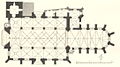 Grundriss Marienkapelle (Würzburg).jpg 1,087 × 603; 659 KB
-
 Immaculata (1713) auf dem Turm der Marienkapelle Würzburg.jpg 3,312 × 4,417; 11.2 MB
-
 Looking to Marienkapelle, Würzburg, 22 Aug 2010 - panoramio.jpg 3,264 × 2,448; 3.1 MB
-
 Maria an der Spitze der Marienkapelle Würzburg.jpg 3,205 × 5,153; 14.2 MB
-
 Marienkapelle (52297181487).jpg 3,024 × 4,032; 10.71 MB
-
 Marienkapelle - panoramio (12).jpg 960 × 1,280; 912 KB
-
 Marienkapelle - panoramio (15).jpg 3,456 × 5,184; 4.24 MB
-
 Marienkapelle - panoramio (16).jpg 3,456 × 5,184; 5.13 MB
-
 Marienkapelle - panoramio (18).jpg 5,184 × 3,456; 4.68 MB
-
 Marienkapelle - panoramio (6).jpg 2,846 × 2,208; 981 KB
-
 Marienkapelle am Marktplatz - panoramio.jpg 1,280 × 873; 739 KB
-
 Marienkapelle fd1 2K,77 D.JPG 4,320 × 3,240; 5.01 MB
-
 Marienkapelle in the night, Würzburg, 23 Aug 2010 - panoramio.jpg 3,264 × 2,448; 2.96 MB
-
 Marienkapelle in Wurzburg 01.jpg 1,642 × 2,658; 2.7 MB
-
 Marienkapelle in Wurzburg 03.jpg 2,024 × 4,186; 4.63 MB
-
 Marienkapelle in Wurzburg 05.jpg 2,534 × 5,427; 7.92 MB
-
 Marienkapelle in Wurzburg 06.jpg 2,183 × 3,994; 4.62 MB
-
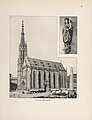
 Marienkapelle in Würzburg (1944), WV2148.jpg 600 × 455; 100 KB
-
 Marienkapelle Marktplatz Würzburg 01.JPG 4,320 × 3,240; 5.48 MB
-
 Marienkapelle Marktplatz Würzburg 02.JPG 3,240 × 4,320; 5.45 MB
-
 Marienkapelle Nachtaufnahme (1).JPG 3,125 × 4,405; 7.68 MB
-
 Marienkapelle u Haus z Falken Nachtaufnahme (2).JPG 4,163 × 3,298; 6.99 MB
-
 Marienkapelle Würzburg - DSC02778.JPG 4,320 × 3,240; 5.45 MB
-
 Marienkapelle Würzburg - IMG 6730.JPG 2,448 × 3,264; 2.44 MB
-
 Marienkapelle Würzburg - IMG 6731.JPG 2,448 × 3,264; 2.59 MB
-
 Marienkapelle Würzburg - IMG 6735.JPG 2,448 × 3,264; 2.31 MB
-
 Marienkapelle Würzburg - IMG 6775.JPG 2,448 × 3,264; 2.68 MB
-
 Marienkapelle Würzburg 1377-1480 - panoramio.jpg 3,127 × 2,344; 1.51 MB
-
 Marienkapelle Würzburg as seen from Festung Marienberg 20140112 1.jpg 3,734 × 4,995; 5.03 MB
-
 Marienkapelle Würzburg IMPG1571.jpg 4,342 × 3,239; 2.58 MB
-
 Marienkapelle Würzburg, 2.jpg 4,351 × 5,599; 8.52 MB
-
 Marienkapelle Würzburg, South-West View 20140107 15.jpg 4,054 × 5,405; 4.16 MB
-
 Marienkapelle Würzburg, Statue Close-up 20131227 1.jpg 2,879 × 4,030; 2.32 MB
-
 Marienkapelle Würzburg.jpg 4,071 × 4,951; 4.79 MB
-
 Marienkapelle Würzburg1.jpg 3,280 × 2,501; 4.83 MB
-
 Marienkapelle, Würzburg, Southwest view 20200622 1.jpg 4,012 × 6,018; 8.1 MB
-
 Marienkapelle.JPG 1,313 × 1,750; 933 KB
-
 MarienkapelleWürzburg1845PeterGeistL1050207 (2).jpg 2,125 × 2,626; 1.13 MB
-
 Rear view - Marienkapelle -Würzburg - Germany 2017.jpg 3,328 × 5,122; 4.55 MB
-
 Verkündigung des Herrn.jpg 1,577 × 2,103; 495 KB
-
 Wuerzburg Marktkirche W-Fassade f sw.jpg 600 × 800; 172 KB
-
 Wuerzburg-Marienkapelle 06-am Marktplatz-2014-gje.jpg 3,061 × 3,517; 1.81 MB
-
 Wuerzburg-Marienkapelle 08-am Marktplatz-2014-gje.jpg 3,456 × 4,365; 2.76 MB
-
 Wuerzburg-Marienkapelle 10-am Marktplatz-2014-gje.jpg 3,171 × 4,752; 2.45 MB
-
 Wuerzburg-Marienkapelle-02-2007-gje.jpg 2,168 × 2,192; 1.31 MB
-
 Wuerzburg-Marienkapelle-04-2007-gje.jpg 2,048 × 3,006; 2.27 MB
-
 Wuerzburg-Marienkapelle-12-Turmmadonna-2007-gje.jpg 2,048 × 2,624; 1.39 MB
-
 Wuerzburg-Marienkapelle-14-Portal-2007-gje.jpg 2,048 × 2,923; 1.59 MB
-
 Wuerzburg-Marienkapelle-16-Tympanon-2007-gje.jpg 3,072 × 2,048; 2.14 MB
-
 Wuerzburg-Marienkapelle-18-zum Chor-2007-gje.jpg 2,048 × 2,572; 1.64 MB
-
 Wuerzburg-Marienkapelle-20-zum Chor-2007-gje.jpg 2,048 × 3,072; 1.93 MB
-
 Wurzburg - Marienkapelle.jpg 4,965 × 6,620; 32.72 MB
-
 Wurzburg, Marienkapelle. 640 (NBY 419644).jpg 516 × 821; 87 KB
-
 Wurzburgo, Santa María 1.jpg 2,848 × 4,288; 6.64 MB
-
 Wurzburgo, Santa María 2.jpg 2,848 × 4,288; 7.92 MB
-
 WÜ Marienkapelle BNeumann.jpg 822 × 1,110; 353 KB
-
 WÜ MarienkapelleA.jpg 1,232 × 984; 381 KB
-
 WÜ MarienkapelleN.jpg 1,220 × 933; 318 KB
-
 Würzburg (9529594121) (2).jpg 3,456 × 5,184; 5.39 MB
-
 Würzburg - Marienkapelle (Schild).JPG 3,072 × 2,304; 2.81 MB
-
 Würzburg - Markt - Marienkapelle.jpg 2,816 × 2,112; 1.32 MB
-
 Würzburg - Postkarte 3 Marienkapelle.png 2,162 × 1,355; 1.47 MB
-
 Würzburg Marienberg Mainfränkisches Museum Adam Marienkapelle.JPG 1,960 × 4,608; 4.23 MB
-
 Würzburg Marienberg Mainfränkisches Museum Eva Marienkapelle.JPG 1,966 × 4,608; 4.56 MB
-
 Würzburg Marienkapelle - panoramio.jpg 677 × 1,024; 262 KB
-
 Würzburg Marienkapelle 149.jpg 3,264 × 4,896; 11.18 MB
-
 Würzburg Marienkapelle 150.jpg 3,223 × 4,835; 11.26 MB
-
 Würzburg Marienkapelle 151.jpg 2,828 × 4,242; 7.63 MB
-
 Würzburg Marienkapelle 152.jpg 3,264 × 4,896; 12.33 MB
-
 Würzburg Pfarrkirche.JPG 1,944 × 2,896; 1.4 MB
-
 Würzburg, die Marienkapelle in der Nacht.JPG 1,817 × 2,698; 2.01 MB
-
 Würzburg, die Marienkapelle.JPG 1,545 × 2,384; 877 KB
-
 Würzburg, Kramläden an der Marienkapelle.JPG 2,764 × 1,843; 1.8 MB
-
 Würzburg, Marienkapelle - panoramio (1).jpg 709 × 1,024; 316 KB
-
 Würzburg, Marienkapelle - panoramio (2).jpg 801 × 1,024; 299 KB
-
 Würzburg, Marienkapelle am Unteren Marktplatz (10702508454).jpg 2,801 × 4,204; 12.59 MB
-
 Würzburg, Marienkapelle am Unteren Marktplatz (10702709063).jpg 3,479 × 2,496; 6.11 MB
-
 Würzburg, Marienkapelle und Unterer Markt.JPG 1,843 × 2,764; 922 KB
-
 Würzburg, Marienkapelle, Exterior-001.jpg 3,264 × 4,928; 8.37 MB
-
 Würzburg, Marienkapelle, Exterior-002.jpg 3,264 × 4,928; 8.98 MB
-
 Würzburg, Marienkapelle, Exterior-003.jpg 3,154 × 4,762; 8.15 MB
-
 Würzburg, Marienkapelle, Exterior-004.jpg 4,928 × 3,264; 7.48 MB
-
 Würzburg, Marienkapelle, Exterior-005.jpg 4,928 × 3,264; 7.98 MB
-
 Würzburg, Marienkapelle, Exterior-006.jpg 3,060 × 4,620; 8.47 MB
-
 Würzburg, Marienkapelle, Exterior-007.jpg 3,095 × 4,673; 8.29 MB
-
 Würzburg, Marienkapelle, Exterior-008.jpg 4,928 × 3,264; 10.15 MB
-
 Würzburg, Marienkapelle, Exterior-009.jpg 3,264 × 4,928; 9.52 MB
-
 Würzburg, Marienkapelle-20151106-001.jpg 3,264 × 4,928; 7.77 MB
-
 Würzburg, Marienkapelle-20151106-002.jpg 4,928 × 3,264; 9.42 MB
-
 Würzburg, Marktplatz - panoramio (1).jpg 967 × 1,280; 1.06 MB
-
 Würzburg, Unterer Markt und Marienkapelle.JPG 1,843 × 2,654; 1.12 MB
.jpg)


_074.jpg)
.jpg)
_von_Jacob_van_der_Auwera.jpg)


_W%C3%BCrzburg_(serietitel),_RP-F-F06208.jpg)

.jpg)
_auf_dem_Turm_der_Marienkapelle_W%C3%BCrzburg.jpg)


.jpg)
.jpg)
.jpg)
.jpg)
.jpg)
.jpg)


,_WV2148.jpg)


.JPG)
.JPG)


.jpg)


.jpg)


_(2).jpg)
.JPG)


.jpg)
.jpg)
.jpg)
.jpg)


.jpg)
