Category:Mariakerk, Apeldoorn
Jump to navigation
Jump to search
| Object location | | View all coordinates using: OpenStreetMap |
|---|
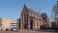
church in Apeldoorn, Netherlands  | |||||
| Upload media | |||||
| Instance of | |||||
|---|---|---|---|---|---|
| Dedicated to | |||||
| Location | Apeldoorn, Gelderland, Netherlands | ||||
| Street address |
| ||||
| Located on street | |||||
| Architect | |||||
| Heritage designation |
| ||||
 | |||||
Nederlands: O.L.Vrouw ten Hemelopneming- of Mariakerk - anno 1898
|
This is a category about rijksmonument number 8161
|
| Address |
|
Subcategories
This category has only the following subcategory.
W
- Wedding of Prince Jaime and Viktória Cservenyák (1 P, 23 F)
Media in category "Mariakerk, Apeldoorn"
The following 21 files are in this category, out of 21 total.
-
 Aanzicht - Apeldoorn - 20023265 - RCE.jpg 1,200 × 805; 271 KB
-
 Altaar Mariakerk (Apeldoorn).jpg 3,174 × 4,768; 1.54 MB
-
 Apeldoorn Mariakerk.jpg 3,760 × 2,876; 9.98 MB
-
 Apeldoorn, de Mariakerk RM8161 foto8 2015-04-05 15.51.jpg 4,344 × 3,258; 10.97 MB
-
 Apeldoorn, de Mariakerk RM8161 IMG 3734 2020-03-27 12.08.jpg 5,472 × 3,104; 9.88 MB
-
 Apeldoorn, kerk1 foto7 2010-04-18 13.28.JPG 3,456 × 2,592; 5.89 MB
-
 Entree Mariakerk (Apeldoorn).jpg 5,184 × 3,480; 2.03 MB
-
 Interieur - Apeldoorn - 20023267 - RCE.jpg 953 × 1,200; 249 KB
-
 Interieur hoofdstraat - Apeldoorn - 20023266 - RCE.jpg 963 × 1,200; 250 KB
-
 Interieur, aanzicht orgel - Apeldoorn - 20417289 - RCE.jpg 802 × 1,200; 161 KB
-
 INTERIEUR, OVERZICHT - Apeldoorn - 20299608 - RCE.jpg 957 × 1,200; 209 KB
-
 INTERIEUR, OVERZICHT - Apeldoorn - 20299609 - RCE.jpg 956 × 1,200; 237 KB
-
 INTERIEUR, OVERZICHT - Apeldoorn - 20299610 - RCE.jpg 954 × 1,200; 200 KB
-
 INTERIEUR, OVERZICHT - Apeldoorn - 20299611 - RCE.jpg 956 × 1,200; 213 KB
-

-

-

-
 Kapel Mariakerk (Apeldoorn).jpg 5,184 × 3,888; 2.74 MB
-
 Koor, hoofdstraat - Apeldoorn - 20023264 - RCE.jpg 1,200 × 803; 319 KB
-
 Mariakerk Apeldoorn.jpg 2,736 × 3,648; 2.45 MB
-
 Schip Mariakerk (Apeldoorn).jpg 5,184 × 3,888; 2.4 MB

.jpg)


.jpg)


.jpg)


.jpg)