Category:Maria en Sint Antoniuskerk (Aalst, Zaltbommel)
Jump to navigation
Jump to search
| Object location | | View all coordinates using: OpenStreetMap |
|---|
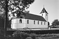
Nederlands: Afbeeldingen van de Maria en Sint Antoniuskerk (Aalst, Zaltbommel), Kerkstraat 1, 5308 KH Aalst. Gelegen in Alst behorende tot de gemeente Zaltbommel in de provincie Gelderland in Nederland. Het is een rijksmonument
Kerk:
|
This is a category about rijksmonument number 10070
|
Toren:
|
This is a category about rijksmonument number 10071
|
church in Aalst, Netherlands  | |||||
| Upload media | |||||
| Instance of | |||||
|---|---|---|---|---|---|
| Dedicated to | |||||
| Location | Aalst, Brakel | ||||
| Street address |
| ||||
| Heritage designation |
| ||||
| Inception |
| ||||
 | |||||
Media in category "Maria en Sint Antoniuskerk (Aalst, Zaltbommel)"
The following 14 files are in this category, out of 14 total.
-
 Buste van Echbert Klop - Aalst - 20003441 - RCE.jpg 887 × 1,200; 176 KB
-
 Exterieur - Aalst - 20003446 - RCE.jpg 1,200 × 802; 325 KB
-
 Exterieur - Aalst - 20003447 - RCE.jpg 1,200 × 1,184; 317 KB
-
 Exterieur - Aalst - 20003448 - RCE.jpg 1,200 × 1,184; 237 KB
-
 Exterieur - Aalst - 20003449 - RCE.jpg 1,200 × 1,195; 252 KB
-
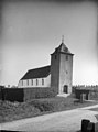 Exterieur vanuit het noord-westen - Aalst - 20003440 - RCE.jpg 887 × 1,200; 142 KB
-
 Interieur, zicht richting orgel - Aalst - 20403266 - RCE.jpg 1,200 × 966; 182 KB
-
 Noord-oost gevel - Aalst - 20003450 - RCE.jpg 1,200 × 804; 238 KB
-
 Overzicht van kerk, gezien naar het zuidoosten - Aalst - 20403264 - RCE.jpg 968 × 1,200; 205 KB
-
 PKN-N-H Maria-en-Sint-Antonius Aalst 2 pagebanner.jpg 4,000 × 571; 883 KB
-
 PKN-N-H Maria-en-Sint-Antonius Aalst 2.jpg 4,000 × 3,000; 5.02 MB
-
 PKN-N-H Maria-en-Sint-Antonius Aalst.jpg 4,000 × 3,000; 5.34 MB
-
 Tinnen doopbekken - Aalst - 20003442 - RCE.jpg 895 × 1,200; 121 KB
-
 Zuid-oost gevel - Aalst - 20003451 - RCE.jpg 1,200 × 803; 155 KB


