Category:Maresfield
Jump to navigation
Jump to search
village and civil parish in East Sussex, England, UK  | |||||
| Upload media | |||||
| Instance of | |||||
|---|---|---|---|---|---|
| Location | Wealden, East Sussex, South East England, England | ||||
| Area |
| ||||
| official website | |||||
 | |||||
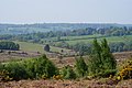
English: Maresfield is a village and civil parish in the Wealden District of East Sussex, England. The village itself lies 1.5 miles (2.4 km) north of Uckfield; the nearby villages of Nutley and Fairwarp; and the smaller settlements of Duddleswell and Horney Common; and parts of Ashdown Forest all lie within Maresfield parish.

Subcategories
This category has the following 14 subcategories, out of 14 total.
B
- Brickfield Meadow (1 F)
C
- Chequers Hotel, Maresfield (9 F)
D
- Duddleswell (14 F)
F
H
- Horney Common (3 F)
M
N
O
- Oasts in Maresfield (3 F)
R
- Roads in Maresfield (181 F)
- Rock Wood (1 F)
Media in category "Maresfield"
The following 200 files are in this category, out of 495 total.
(previous page) (next page)-
 31 bus in Batts Bridge Road - geograph.org.uk - 4982497.jpg 640 × 480; 141 KB
-
 A corner of Ashdown Forest - geograph.org.uk - 6278388.jpg 640 × 480; 87 KB
-
 A corner of Ashdown Forest - geograph.org.uk - 6278398.jpg 640 × 480; 101 KB
-
 A stream on Ashdown Forest - geograph.org.uk - 5418580.jpg 4,000 × 3,000; 4.81 MB
-
 A272 - geograph.org.uk - 5226429.jpg 640 × 495; 114 KB
-
 A272 at Batts Bridge Roundabout - geograph.org.uk - 5226431.jpg 640 × 363; 73 KB
-
 Abandoned vehicles on Dodds Bank - geograph.org.uk - 2818375.jpg 4,000 × 3,000; 3.65 MB
-
 Airman's Grave - geograph.org.uk - 6278383.jpg 640 × 480; 85 KB
-
 Approaching Camp Hill Clump - geograph.org.uk - 5216972.jpg 4,000 × 3,000; 4.9 MB
-
 Approaching the top of Camp Hill - geograph.org.uk - 2955941.jpg 640 × 430; 81 KB
-
 Ashdown Chase, Nutley - geograph.org.uk - 5843231.jpg 1,024 × 768; 171 KB
-
 Ashdown Forest - geograph.org.uk - 5417777.jpg 4,000 × 3,000; 4.87 MB
-
 Ashdown Forest - geograph.org.uk - 5417778.jpg 4,000 × 3,000; 4.73 MB
-
 Ashdown Forest - geograph.org.uk - 5592053.jpg 4,000 × 3,000; 4.82 MB
-
 Ashdown Forest - geograph.org.uk - 5592056.jpg 3,730 × 2,797; 2.07 MB
-
 Ashdown Forest - geograph.org.uk - 5592061.jpg 4,000 × 3,000; 5.1 MB
-
 Ashdown Forest from the air - geograph.org.uk - 5948770.jpg 2,651 × 1,878; 516 KB
-
 Autumn on Ashdown Forest - geograph.org.uk - 5607345.jpg 4,000 × 3,000; 4.94 MB
-
 Autumn on Ashdown Forest - geograph.org.uk - 5607365.jpg 4,000 × 3,000; 4.92 MB
-
 Autumnal Red Oaks at Park Farm - geograph.org.uk - 2110336.jpg 2,592 × 1,944; 2.41 MB
-
 Barn near the road - geograph.org.uk - 2893811.jpg 4,000 × 3,000; 2.18 MB
-
 Barnsden Farm - geograph.org.uk - 2958793.jpg 640 × 430; 69 KB
-
 Barnsgate Manor restaurant - geograph.org.uk - 1818789.jpg 1,600 × 1,200; 733 KB
-
 Barnsgate Manor Vineyard - geograph.org.uk - 1840572.jpg 640 × 582; 124 KB
-
 Barnsgate Manor Vineyard - geograph.org.uk - 1840580.jpg 640 × 430; 71 KB
-
 Barnsgate Manor Vineyard - geograph.org.uk - 3012886.jpg 640 × 430; 52 KB
-
 Barnsgate Manor Vineyard - geograph.org.uk - 3498196.jpg 640 × 430; 83 KB
-
 Barnsgate vineyard at Barnsgate Manor - geograph.org.uk - 1818771.jpg 1,600 × 1,200; 486 KB
-
 Batt's Farm - geograph.org.uk - 1982302.jpg 1,024 × 768; 249 KB
-
 Beech trees near Nutley Windmill - geograph.org.uk - 5241288.jpg 4,000 × 3,000; 4.79 MB
-
 Bell Lane - geograph.org.uk - 5582579.jpg 925 × 1,024; 224 KB
-
 Birch trees on the edge of Campfields Rough - geograph.org.uk - 2758589.jpg 4,000 × 3,000; 3.48 MB
-
 Birch Woodland, Ashdown Forest - geograph.org.uk - 2197178.jpg 640 × 480; 157 KB
-
 Birch Woodland, Ashdown Forest - geograph.org.uk - 2197217.jpg 640 × 480; 83 KB
-
 Blossom in the woods by Nursery Lane - geograph.org.uk - 2983569.jpg 640 × 430; 133 KB
-
 Bowbells milepost - geograph.org.uk - 2111316.jpg 2,592 × 1,944; 1.83 MB
-
 Bridge across Shortbridge Stream - geograph.org.uk - 5560854.jpg 4,896 × 3,672; 5.63 MB
-
 Bridleway approaching Hunters Farm - geograph.org.uk - 3683467.jpg 2,048 × 3,072; 893 KB
-
 Bridleway between Hunters Farm and Woodcock Farm - geograph.org.uk - 2196228.jpg 3,264 × 2,448; 6.19 MB
-
 Brown's Brook - geograph.org.uk - 2961700.jpg 640 × 430; 143 KB
-
 Brown's Brook - geograph.org.uk - 2961701.jpg 640 × 430; 149 KB
-
 Brown's Brook - geograph.org.uk - 2961702.jpg 640 × 430; 149 KB
-
 Budlett's Roundabout - geograph.org.uk - 1839127.jpg 640 × 430; 55 KB
-
 Burrell Lane, Nursery Lane junction - geograph.org.uk - 2983522.jpg 640 × 430; 65 KB
-
 Bushes and gorse - geograph.org.uk - 2952282.jpg 640 × 430; 74 KB
-
 Camp Hill Clump - geograph.org.uk - 2955947.jpg 640 × 430; 90 KB
-
 Camp Hill Clump - geograph.org.uk - 2955952.jpg 640 × 430; 84 KB
-
 Camp Hill Clump - geograph.org.uk - 3422438.jpg 4,000 × 3,000; 3.85 MB
-
 Camp Hill Clump on Ashdown Forest - geograph.org.uk - 2761216.jpg 4,000 × 3,000; 3.23 MB
-
 Camp Hill Clump, Ashdown Forest - geograph.org.uk - 2666243.jpg 4,000 × 3,000; 4.29 MB
-
 Camp Hill Clump, Ashdown Forest - geograph.org.uk - 2666244.jpg 4,000 × 3,000; 4.21 MB
-
 Camp Hill Clump, Ashdown Forest - geograph.org.uk - 5216976.jpg 4,000 × 3,000; 4.8 MB
-
 Camp Hill Clump, Ashdown Forest - geograph.org.uk - 5216982.jpg 4,000 × 3,000; 4.48 MB
-
 Camp Hill Clump, Ashdown Forest - geograph.org.uk - 6202380.jpg 1,024 × 684; 387 KB
-
 Camp Hill trig point, Ashdown Forest - geograph.org.uk - 6202403.jpg 1,024 × 768; 396 KB
-
 Camp Hill Trigpoint - geograph.org.uk - 4648233.jpg 640 × 359; 57 KB
-
 Camp Hill, Ashdown Forest, Sussex - geograph.org.uk - 2381647.jpg 3,872 × 2,592; 5.83 MB
-
 Camphill Clump - geograph.org.uk - 6278511.jpg 640 × 480; 90 KB
-
 Car park off Crowborough Road - geograph.org.uk - 2757484.jpg 4,000 × 3,000; 3.57 MB
-
 Cattle grid on Crowborough Road, Ashdown Forest - geograph.org.uk - 5843313.jpg 1,024 × 768; 231 KB
-
 Cattle in the road, Ashdown Forest - geograph.org.uk - 5843291.jpg 1,024 × 768; 270 KB
-
 Cattle on the road, Ashdown Forest - geograph.org.uk - 5843309.jpg 1,024 × 768; 249 KB
-
 Chequers Inn, Maresfield - geograph.org.uk - 4982738.jpg 640 × 480; 58 KB
-
 Chestnut Cottages - geograph.org.uk - 2195736.jpg 640 × 480; 75 KB
-
 Chestnut Farm - geograph.org.uk - 2195730.jpg 640 × 480; 110 KB
-
 Christ Church, Fairwarp - geograph.org.uk - 5560836.jpg 4,896 × 3,672; 6.12 MB
-
 Church path, Maresfield Parish Church - geograph.org.uk - 2459199.jpg 1,600 × 1,200; 723 KB
-
 Claygate Farm - geograph.org.uk - 4852148.jpg 640 × 426; 68 KB
-
 Cleared heather near Camp Hill - geograph.org.uk - 2955957.jpg 640 × 430; 76 KB
-
 Cleared scrubland at the southern end of Ashdown Forest - geograph.org.uk - 2813772.jpg 4,000 × 3,000; 3.5 MB
-
 Clock House Lane - geograph.org.uk - 2195114.jpg 640 × 480; 93 KB
-
 Clump of Trees - geograph.org.uk - 1981840.jpg 1,024 × 768; 202 KB
-
 Coat of arms, Oldlands Hall gateway - geograph.org.uk - 1751547.jpg 428 × 640; 139 KB
-
 Coat of arms, Oldlands Hall gateway - geograph.org.uk - 1751559.jpg 428 × 640; 139 KB
-
 Cobdown Lane - geograph.org.uk - 2990755.jpg 640 × 430; 113 KB
-
 Cobdown Lane - geograph.org.uk - 5032400.jpg 640 × 426; 64 KB
-
 Cobdown Lane - geograph.org.uk - 5949667.jpg 1,024 × 806; 183 KB
-
 Conifers in Hollybush Wood - geograph.org.uk - 2198667.jpg 3,264 × 2,448; 5.81 MB
-
 Conifers NE of Nutley Windmill - geograph.org.uk - 2762543.jpg 4,000 × 3,000; 3.67 MB
-
 Converted barn on Bell Lane - geograph.org.uk - 2893817.jpg 3,050 × 2,446; 1.36 MB
-
 Coppice by the Wealdway - geograph.org.uk - 2958773.jpg 640 × 430; 147 KB
-
 Coppice fencing, Nursery Lane - geograph.org.uk - 2969987.jpg 640 × 430; 110 KB
-
 Coppiced tree, Brown's Brook - geograph.org.uk - 2958798.jpg 640 × 430; 153 KB
-
 Coppicing in Ann Wood - geograph.org.uk - 2198630.jpg 3,264 × 2,448; 4.15 MB
-
 Cottage by The Wealdway - geograph.org.uk - 2961710.jpg 640 × 430; 108 KB
-
 Cottage, Millwood Lane - geograph.org.uk - 2990757.jpg 640 × 430; 117 KB
-
 Cottages, High St - geograph.org.uk - 2988579.jpg 640 × 430; 86 KB
-
 Covered reservoir - geograph.org.uk - 2983529.jpg 640 × 430; 84 KB
-
 Crest Farm - geograph.org.uk - 2958790.jpg 640 × 430; 110 KB
-
 Cropped conifer at Mark Street - geograph.org.uk - 2198643.jpg 3,264 × 2,448; 3.77 MB
-
 Crowborough Road, Ashdown Forest - geograph.org.uk - 5843319.jpg 1,024 × 768; 190 KB
-
 Crowborough Road, near Nutley - geograph.org.uk - 5843268.jpg 1,024 × 768; 207 KB
-
 Crowborough Road, near Nutley - geograph.org.uk - 5843273.jpg 1,024 × 768; 221 KB
-
 Crowborough Road, Nutley - geograph.org.uk - 5843253.jpg 1,024 × 768; 275 KB
-
 Crows Nest Clump, Ashdown Forest - geograph.org.uk - 6036159.jpg 4,000 × 3,000; 4.83 MB
-
 Cut through Maskett's Wood - geograph.org.uk - 2198614.jpg 3,264 × 2,448; 5.47 MB
-
 Daffodil time at Duddleswell Tea Rooms - geograph.org.uk - 3422545.jpg 4,000 × 3,000; 4.03 MB
-
 Daffodils, Millwood Lane - geograph.org.uk - 2990760.jpg 640 × 430; 100 KB
-
 Deer from the roadside - geograph.org.uk - 1628259.jpg 615 × 461; 70 KB
-

-

-

-

-
 Disused well at Park Farm - geograph.org.uk - 2110329.jpg 2,592 × 1,944; 2.38 MB
-
 Dog Bar - geograph.org.uk - 6278392.jpg 480 × 640; 115 KB
-
 Driveway and footpath, Ashdown Forest - geograph.org.uk - 5843325.jpg 1,024 × 768; 345 KB
-
 Driveway off Underhill - geograph.org.uk - 2990748.jpg 640 × 430; 128 KB
-
 Duddleswell Tea Room, Ashdown Forest - geograph.org.uk - 5843323.jpg 1,024 × 768; 246 KB
-
 Early Morning Sun, Ashdown Forest - geograph.org.uk - 2193502.jpg 640 × 480; 218 KB
-
 Eastern edge of Great Birch Wood - geograph.org.uk - 2818546.jpg 4,000 × 3,000; 3.51 MB
-
 Ellison's Pond - geograph.org.uk - 2762398.jpg 4,000 × 3,000; 3.33 MB
-
 Ellison's Pond - geograph.org.uk - 6278403.jpg 640 × 480; 107 KB
-
 Ellison's Pond - geograph.org.uk - 6278406.jpg 640 × 480; 94 KB
-
 Ellison's Pond perhaps, Ashdown Forest - geograph.org.uk - 6202407.jpg 1,024 × 768; 393 KB
-
 Ellison's Pond, Ashdown Forest - geograph.org.uk - 5216618.jpg 4,000 × 3,000; 4.71 MB
-
 Ellison's Pond, Ashdown Forest - geograph.org.uk - 5345116.jpg 4,000 × 3,000; 5.11 MB
-
 Ellison's Pond, Ashdown Forest at dusk - geograph.org.uk - 5607600.jpg 4,000 × 3,000; 4.72 MB
-
 Entrance to Barnsgate Manor - geograph.org.uk - 5027230.jpg 640 × 426; 92 KB
-
 Entrance to Crest Farm, Ashdown Forest - geograph.org.uk - 3023330.jpg 4,000 × 3,000; 4.15 MB
-
 Entrance to Oldlands Hall - geograph.org.uk - 1817021.jpg 1,600 × 1,200; 568 KB
-
 Entrance to Woodcock Farm - geograph.org.uk - 1741277.jpg 640 × 427; 96 KB
-
 Fallen trees in woodland pool in Hendall Wood - geograph.org.uk - 1814260.jpg 1,600 × 1,200; 847 KB
-
 Farm machinery etc on Barnsden Farm - geograph.org.uk - 1818547.jpg 1,600 × 1,200; 592 KB
-
 Farm machinery storage barn at Hendall Manor Farm - geograph.org.uk - 1814324.jpg 1,600 × 1,200; 587 KB
-
 Farmland by Nursery Lane - geograph.org.uk - 2969995.jpg 640 × 430; 62 KB
-
 Farmland by Nursery Lane - geograph.org.uk - 2983555.jpg 640 × 430; 74 KB
-
 Farmland west of the A26 - geograph.org.uk - 3012879.jpg 640 × 430; 30 KB
-
 Field by the A26 - geograph.org.uk - 4852167.jpg 640 × 426; 45 KB
-
 Field near Maresfield recycling plant. - geograph.org.uk - 4357699.jpg 4,000 × 2,664; 5.23 MB
-
 Field view to outskirts of Fairwarp - geograph.org.uk - 1815858.jpg 1,600 × 1,200; 521 KB
-
 Field, Budlett's Common - geograph.org.uk - 1382102.jpg 640 × 480; 96 KB
-
 Fields and Sky near to Woodcock Farm - geograph.org.uk - 5563299.jpg 1,024 × 611; 134 KB
-
 Fields by Goldbridge Road near Maresfield - geograph.org.uk - 4913818.jpg 2,048 × 1,536; 1.31 MB
-

-
 Filming on Ashdown Forest - geograph.org.uk - 5217631.jpg 4,000 × 3,000; 4.54 MB
-
 Filming on Ashdown Forest - geograph.org.uk - 5217634.jpg 4,000 × 3,000; 4.62 MB
-
 Finger post, Ashdown Forest - geograph.org.uk - 2955971.jpg 640 × 430; 107 KB
-
 Finger post, B2026 - geograph.org.uk - 2955975.jpg 640 × 430; 127 KB
-
 Flowering gorse on Ashdown Forest - geograph.org.uk - 5345115.jpg 4,000 × 3,000; 4.81 MB
-
 Footbridge at the northern edge of Hendall Wood - geograph.org.uk - 1814273.jpg 1,600 × 1,200; 923 KB
-
 Footbridge for the Weald Way - geograph.org.uk - 215299.jpg 640 × 480; 320 KB
-
 Footbridge in Furnace Wood - geograph.org.uk - 1982258.jpg 1,024 × 768; 298 KB
-
 Footbridge in Little Birch Wood by Dodd's Hill - geograph.org.uk - 2818379.jpg 4,000 × 3,000; 3.32 MB
-
 Footbridge on the edge of Great Birch Wood - geograph.org.uk - 2818530.jpg 4,000 × 3,000; 3.49 MB
-
 Footbridge on The Wealdway - geograph.org.uk - 2961704.jpg 640 × 430; 129 KB
-
 Footbridge over a small woodland stream - geograph.org.uk - 2966377.jpg 640 × 430; 118 KB
-
 Footbridge over Millbrook - geograph.org.uk - 2762574.jpg 4,000 × 3,000; 3.56 MB
-
 Footbridge over Shortbridge Stream - geograph.org.uk - 1815409.jpg 1,600 × 1,200; 694 KB
-
 Footbridge, Ashdown Forest - geograph.org.uk - 2197168.jpg 480 × 640; 128 KB
-
 Footpath approach to Pricket's Hatch - geograph.org.uk - 2198670.jpg 3,264 × 2,448; 5.26 MB
-
 Footpath approaching Londonderry Farm - geograph.org.uk - 2757326.jpg 4,000 × 3,000; 3.4 MB
-
 Footpath connecting Crowborough Road with the B2026 - geograph.org.uk - 2758524.jpg 4,000 × 3,000; 3.65 MB
-
 Footpath crossing in Access land wood - geograph.org.uk - 1815789.jpg 1,600 × 1,200; 884 KB
-
 Footpath in Ashdown Forest - geograph.org.uk - 5843257.jpg 1,024 × 768; 259 KB
-
 Footpath in Ashdown Forest near Lower Mishbourne Farm - geograph.org.uk - 2818404.jpg 4,000 × 3,000; 3.36 MB
-
 Footpath in Maresfield - geograph.org.uk - 2988597.jpg 640 × 430; 118 KB
-
 Footpath junction with the B2026 - geograph.org.uk - 1817129.jpg 1,600 × 1,200; 758 KB
-
 Footpath near Fairwarp - geograph.org.uk - 5560837.jpg 3,672 × 4,896; 5.42 MB
-
 Footpath near to Hunters Farm - geograph.org.uk - 5563234.jpg 1,024 × 532; 97 KB
-
 Footpath off Millwood Lane - geograph.org.uk - 2990759.jpg 640 × 430; 116 KB
-
 Footpath off Nursery Lane - geograph.org.uk - 2969989.jpg 640 × 430; 133 KB
-
 Footpath off Nursery Lane - geograph.org.uk - 2969993.jpg 640 × 430; 152 KB
-
 Footpath off Nursery Lane - geograph.org.uk - 2970008.jpg 640 × 430; 81 KB
-
 Footpath off Nursery Lane - geograph.org.uk - 2983544.jpg 640 × 430; 121 KB
-
 Footpath off the A26 to Hendall Farm - geograph.org.uk - 3012880.jpg 640 × 372; 36 KB
-
 Footpath over rough pasture to Hendall Wood - geograph.org.uk - 1814227.jpg 1,600 × 1,200; 438 KB
-
 Footpath passes woodland - geograph.org.uk - 5563345.jpg 1,024 × 637; 180 KB
-
 Footpath subway under the A22 - geograph.org.uk - 2110323.jpg 2,592 × 1,944; 2.07 MB
-
 Footpath SW to Reeding's Farm - geograph.org.uk - 1815397.jpg 1,600 × 1,200; 521 KB
-
 Footpath to Fairwarp - geograph.org.uk - 2966378.jpg 640 × 430; 131 KB
-
 Footpath to Nutley - geograph.org.uk - 2195015.jpg 640 × 480; 146 KB
-

-
 Ford at Ford's Bank - geograph.org.uk - 2813884.jpg 4,000 × 3,000; 3.56 MB
-
 Ford at Horney Common - geograph.org.uk - 3743115.jpg 3,872 × 2,592; 4.65 MB
-
 Ford on Oldlands Hill - geograph.org.uk - 2758686.jpg 4,000 × 3,000; 3.35 MB
-
 Ford's Green - geograph.org.uk - 2195688.jpg 640 × 480; 91 KB
-
 Ford's Green - geograph.org.uk - 2195699.jpg 640 × 480; 155 KB
-
 Forest Cottage - geograph.org.uk - 5563211.jpg 1,024 × 663; 189 KB
-
 Forest View, Ashdown Forest, Sussex - geograph.org.uk - 2381621.jpg 3,872 × 2,592; 4.48 MB
-
 Forge Cottage - geograph.org.uk - 2990744.jpg 640 × 430; 74 KB
-
 Foxgloves and Ashdown Forest - geograph.org.uk - 3023399.jpg 4,000 × 3,000; 3.98 MB
-
 Foxgloves on Ashdown Forest - geograph.org.uk - 3023395.jpg 4,000 × 3,000; 4.06 MB
-
 Friend's Clump on Ashdown forest - geograph.org.uk - 2757434.jpg 4,000 × 3,000; 3.73 MB
-
 Friends' Clump - geograph.org.uk - 2707102.jpg 1,600 × 1,050; 211 KB
-
 Friends' Clump, Ashdown Forest - geograph.org.uk - 5241303.jpg 4,000 × 3,000; 4.88 MB
-
 Friends' Clump, Ashdown Forest - geograph.org.uk - 5592058.jpg 4,000 × 3,000; 5 MB
-
 Gas pressure regulator installation - geograph.org.uk - 1815454.jpg 1,600 × 1,200; 545 KB
-
 Gate into Christ Church, Churchyard, Fairwarp - geograph.org.uk - 5560832.jpg 4,896 × 3,672; 5.72 MB
-
 Gate Onto the Ashdown Forest, Sussex - geograph.org.uk - 2381954.jpg 3,872 × 2,592; 5.79 MB
-
 Gates to Oldlands Hall - geograph.org.uk - 5949655.jpg 1,024 × 681; 112 KB
-
 Gateway to Oldlands Hall - geograph.org.uk - 3012882.jpg 640 × 417; 46 KB
-
 Gateway to Oldlands Hall - geograph.org.uk - 3498191.jpg 640 × 430; 67 KB
-
 Gateway to the Ashdown Forest, Sussex - geograph.org.uk - 2381943.jpg 3,872 × 2,592; 6.05 MB
-
 Gateway, Oldlands Hall - geograph.org.uk - 1751533.jpg 640 × 428; 153 KB
-
 Gathering of gates near Masketts Farm - geograph.org.uk - 2198609.jpg 3,264 × 2,448; 4.93 MB
-
 Gorse and a clump of trees on Ashdown Forest - geograph.org.uk - 5216988.jpg 4,000 × 3,000; 4.84 MB
-
 Gorse and a clump of trees on Ashdown Forest - geograph.org.uk - 5216990.jpg 4,000 × 3,000; 5.2 MB
-
 Gorse and Camp Hill Clump on Ashdown Forest - geograph.org.uk - 5217003.jpg 4,000 × 3,000; 4.5 MB
-
 Gorse and dead bracken on Ashdown Forest - geograph.org.uk - 5607333.jpg 4,000 × 3,000; 4.59 MB
-
 Gorse bush, Wealdway - geograph.org.uk - 2952291.jpg 640 × 430; 68 KB


