Category:Maps of weather and climate in the 19th century
Jump to navigation
Jump to search
Subcategories
This category has the following 3 subcategories, out of 3 total.
Media in category "Maps of weather and climate in the 19th century"
The following 15 files are in this category, out of 15 total.
-
 Earth Temperature.gif 640 × 480; 5.16 MB
-
 Humboldt's System of Isothermal Lines, or Lines of Equal Annual Mean Temperature Over the Globe.jpg 15,045 × 12,666; 32.85 MB
-
 Iconographic Encyclopedia of Science, Literature and Art 040.jpg 2,304 × 2,860; 1.02 MB
-
 Iconographic Encyclopedia of Science, Literature and Art 041.jpg 2,860 × 2,304; 1.48 MB
-
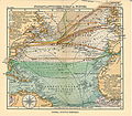 Nordatlantik.jpg 4,555 × 3,974; 7.33 MB
-
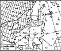
 Otto 3273 Mapa povetrnostni.jpg 1,259 × 1,021; 356 KB
-
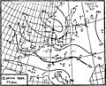
 Otto 3277 Anticyclone moving eastward.jpg 1,243 × 1,012; 311 KB
-
 Otto 3279 Eastern weather type.jpg 1,227 × 1,023; 302 KB
-
 Otto 3280 Southern weather type.jpg 1,248 × 1,001; 349 KB
-
 Otto 3281 Western weather type.jpg 1,260 × 1,023; 314 KB
-
 Rainfall of the Caucasus (Élisée Reclus).JPG 470 × 363; 42 KB
-
 Stiller ozean.jpg 4,555 × 3,956; 7.07 MB
-
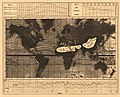
 Woodbridge isothermal chart.jpg 3,360 × 2,636; 4.57 MB
-
 Woodbridge isothermal chart2.jpg 3,357 × 2,628; 6.24 MB
-
 Woodbridge isothermal chart3.jpg 3,338 × 2,413; 6.24 MB


.JPG)


