Category:Maps of the province of Cádiz
Jump to navigation
Jump to search
Provinces of Spain: Álava · Albacete · Alicante · Almería · Asturias‡ · Ávila · Badajoz · Balearic Islands‡ · Barcelona · Biscay · Burgos · Cáceres · Cádiz · Cantabria‡ · Castellón · Ciudad Real · Córdoba · A Coruña · Cuenca · Gipuzkoa · Girona · Granada · Guadalajara · Huelva · Huesca · Jaén · León · Lleida · Lugo · Madrid‡ · Málaga · Murcia‡ · Navarre‡ · Ourense · Palencia · Las Palmas · Pontevedra · La Rioja‡ · Salamanca · Santa Cruz de Tenerife · Segovia · Seville · Soria · Tarragona · Teruel · Toledo · Valencia · Valladolid · Zamora · Zaragoza · Autonomous cities: Ceuta · Melilla
‡: uniprovincial autonomous communities.
‡: uniprovincial autonomous communities.
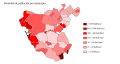
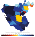
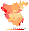
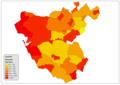
Maps of the province of Cádiz, Andalusia, Spain.

Subcategories
This category has the following 6 subcategories, out of 6 total.
*
C
M
P
Media in category "Maps of the province of Cádiz"
The following 46 files are in this category, out of 46 total.
-

-
 AtaqueDrakes.jpg 895 × 604; 174 KB
-
 A491A480A471A2002PUERTOSANTAMROTASLUCARCHIPIONA.PNG 299 × 245; 10 KB
-

-
 Alcaldías Cádiz 2010.png 600 × 550; 79 KB
-
 Alcaldías Cádiz 2011.png 600 × 550; 78 KB
-
 Andalucia-Hispalensis.jpg 2,367 × 1,800; 665 KB
-
 Area metropo Bahia Cadiz y Jerez.jpg 567 × 540; 106 KB
-
 Areametropolitanacadiz.svg 739 × 705; 665 KB
-
 ATLAS JUSTUS PERTHES 08.jpg 4,547 × 3,933; 10.25 MB
-
 Cadix en 1811.jpg 2,199 × 2,933; 1.83 MB
-
 Wikiproyecto cádiz.PNG 263 × 250; 5 KB
-
 Cadiz 1625.jpg 713 × 1,170; 145 KB
-
 Cadiz 1833 reinos-provincias.png 471 × 291; 23 KB
-
 Cadiz crecimiento poblacion 1998-2008.png 1,000 × 1,045; 107 KB
-
 Cadiz densidad poblacion.svg 778 × 413; 173 KB
-
 Cadiz-crecimiento-poblacion-01-11.png 1,500 × 1,567; 269 KB
-
 Cadiz-crecimiento-poblacion-11-21.png 1,500 × 1,567; 274 KB
-
 Cadiz-densidad-2021.png 1,500 × 1,567; 252 KB
-
 Cadiz-poblacion-2021.png 1,500 × 1,567; 249 KB
-
 Carte de la baye de Gibraltar (1762).jpg 3,000 × 2,133; 1.78 MB
-
 Densidad Cádiz.png 1,170 × 827; 59 KB
-
 Estrecho mapa geologico.png 743 × 405; 134 KB
-
 Estrecho mapa rios.png 1,214 × 647; 380 KB
-
 Gadeiras314-fr.svg 975 × 1,356; 298 KB
-
 Gadeiras314.svg 975 × 1,356; 280 KB
-
 Inmigracion cádiz.png 2,340 × 1,654; 160 KB
-
 Karte Gemeinden Provinz Cádiz 2022.png 2,500 × 2,834; 810 KB
-
 Karte Gemeinden und Gerichtsbezirke Provinz Cádiz 2022.png 3,000 × 3,401; 978 KB
-
 Karte-pn-grazalema.gif 439 × 463; 38 KB
-
 LA INA - Mapa de Francisco Zarzana - 1787.jpg 1,248 × 869; 451 KB
-
 LA INA - Mapa de José Cardano 1809 - 2.jpg 1,250 × 872; 666 KB
-
 Mapa a-390.PNG 732 × 284; 29 KB
-
 Mapa ca-33.PNG 424 × 191; 24 KB
-
 Mapa CA-34.png 281 × 357; 24 KB
-
 Mapa siglo XVIII.jpg 4,320 × 3,240; 5.64 MB
-
 Municipios de Cádiz.png 1,372 × 1,080; 64 KB
-
 Provinz Cádiz 2022.png 2,500 × 2,834; 727 KB
-
 Real Observatorio de Madrid en abril de 2023 111.jpg 3,000 × 4,000; 3.14 MB
-
 Real Observatorio de Madrid en abril de 2023 112.jpg 3,000 × 4,000; 3.69 MB
-
 Real Observatorio de Madrid en abril de 2023 113.jpg 3,000 × 4,000; 3.65 MB
-
 Reilly 545.jpg 1,288 × 1,106; 582 KB
-
 San Roque situacion 1.png 900 × 866; 72 KB
-
 Situationsplan von Cadiz.jpg 500 × 606; 97 KB
-
 Terminopuertoreal.png 1,148 × 663; 210 KB
-
 Área metropolitana Bahia Cadiz-Jerez.jpg 567 × 540; 105 KB
.jpg)


.jpg)


