Category:Maps of the province of Benevento
Jump to navigation
Jump to search
Subcategories
This category has the following 4 subcategories, out of 4 total.
Media in category "Maps of the province of Benevento"
The following 20 files are in this category, out of 20 total.
-
 Benevento map.png 725 × 562; 170 KB
-
 Benevento posizione.png 350 × 424; 11 KB
-
 0824 map.png 745 × 673; 102 KB
-
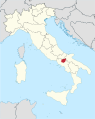 Benevento in Italy.svg 1,034 × 1,299; 3.02 MB
-
 Circondario di Benevento.png 1,043 × 1,200; 229 KB
-
 Circondario di Cerreto Sannita.png 1,043 × 1,200; 229 KB
-
 Circondario di San Bartolomeo in Galdo.png 1,043 × 1,200; 229 KB
-
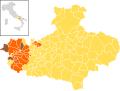
 Map - IT - Benevento - Comunità Montana del Fortore.svg 1,057 × 831; 547 KB
-
 Guardia Sanframondi (31590129366).jpg 3,528 × 2,653; 1.41 MB
-
 Map - IT - Avellino - Comunità Montana Partenio - Vallo di Lauro.svg 1,362 × 1,025; 605 KB
-
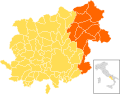
 Map of province of Benevento (region Campania, Italy).svg 2,045 × 1,861; 68 KB
-
 Mappa ferrovia Benevento - Avellino.png 1,299 × 1,896; 2.46 MB
-
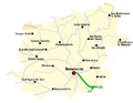
 Mappa ferrovia Benevento-Campobasso.jpg 618 × 1,263; 170 KB
-
 Peutingeriana Aufidus.JPG 1,200 × 736; 217 KB
-
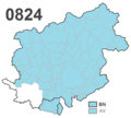
 Prefissi telefonici della provincia di Benevento.png 771 × 721; 110 KB
-
 SS 88 map.png 813 × 4,902; 3.7 MB
-
 Map - IT - Benevento - Comunità Montana del Taburno.svg 1,057 × 831; 547 KB
-
 Map - IT - Benevento - Comunità Montana Titerno e Alto Tammaro.svg 1,057 × 831; 547 KB
-
 Vallardi - Principato Ulteriore e Benevento.jpg 6,294 × 4,108; 10.14 MB
-
 Map - IT - Benevento - Comuni Valle Vitulanese.svg 1,322 × 1,038; 549 KB


.jpg)

.svg)


