Category:Maps of the history of Tatarstan
Jump to navigation
Jump to search
Federal subjects of the Russian Federation:
Republics: Adygea · Bashkortostan · Buryatia · Chechnya · Chuvashia · (Crimea) · Dagestan · Ingushetia · Kabardino-Balkaria · Kalmykia · Karachay–Cherkessia · Karelia · Mari El · Mordovia · North Ossetia — Alania · Tatarstan · UdmurtiaKrais: Krasnoyarsk · Primorsky ·
Oblasts: Arkhangelsk · Belgorod · Bryansk · Kursk · Leningrad · Moscow · Murmansk · Oryol · Pskov · Smolensk · Tver · Voronezh ·
Federal cities: Moscow · Saint Petersburg ·
Autonomous oblast:
Autonomous okrugs:
Subcategories
This category has the following 3 subcategories, out of 3 total.
H
- Historical maps of Kazan (23 F)
M
- Maps of Kazan Governorate (50 F)
- Maps of the Golden Horde (55 F)
Media in category "Maps of the history of Tatarstan"
The following 32 files are in this category, out of 32 total.
-
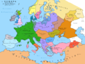
 Europe 814.jpg 1,477 × 1,164; 302 KB
-
 =Казанское Общество Трезвости и его 61 отдел=.JPG 2,370 × 1,654; 888 KB
-
 Avrupa 814.jpg 1,477 × 1,164; 383 KB
-
 Bulgar subsequent migrations in Europe..jpg 650 × 414; 49 KB
-
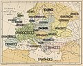
 Das Großbulgarische Reich (650-922).png 752 × 639; 94 KB
-
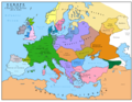
 Europa 814.png 1,350 × 1,022; 167 KB
-
 Europe 814 hun.jpg 1,477 × 1,164; 353 KB
-
 Europe 814 japref.jpg 1,450 × 1,150; 349 KB
-
 Europe 814.png 1,393 × 1,075; 169 KB
-
 Groot-Bulgaarse Rijk (650-922).PNG 752 × 591; 37 KB
-
 Kazan 1552.png 1,132 × 887; 362 KB
-
 Kazan Khanate map Tatar.svg 800 × 920; 150 KB
-
 KazanKhanate1500.png 1,264 × 788; 39 KB
-
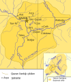
 Pontic steppe region around 650 AD-svg-en.svg 512 × 444; 94 KB
-
 Pontic steppe region around 650 AD-svg-es.svg 523 × 549; 1.22 MB
-
 Pontic steppe region around 650 AD-svg-fr.svg 512 × 444; 94 KB
-
 Pontic steppe region around 650 AD-zh.svg 1,473 × 1,280; 85 KB
-
 Pontic steppe region around 650 AD.png 637 × 553; 40 KB
-
 Premongol.png 752 × 590; 31 KB
-
 PremongolEurasia-ar.png 752 × 590; 60 KB
-
 PremongolEurasia.png 752 × 590; 31 KB
-
 Prise de Kazan 1552.svg 709 × 560; 62 KB
-
 Pugachev War Tatarstan English.svg 920 × 720; 145 KB
-
 VolgaBulgaria1200.png 1,264 × 788; 38 KB
-
 Zakamje zascherta.png 745 × 920; 120 KB
-
 Δνείπ-Βόλγ 10ος αι.jpg 872 × 886; 182 KB
-

-
 Области Татарской и Башкирской АССР 1953.png 800 × 576; 156 KB
-
 Протобулгарские некрополи.JPG 693 × 353; 66 KB
-
 Схема Татаро-Башкирской Республики 1918 год.png 556 × 399; 61 KB
-
 Этнографик карта.jpg 720 × 539; 108 KB
-
 Этнографическая карта ТАССР по данным переписи 1920 года.jpg 2,007 × 1,568; 886 KB


.png)


.PNG)


