Category:Maps of the Worcester Consolidated Street Railway
Jump to navigation
Jump to search
Media in category "Maps of the Worcester Consolidated Street Railway"
The following 9 files are in this category, out of 9 total.
-
 1906 map of the Worcester Consolidated Street Railway.jpg 1,522 × 1,782; 150 KB
-
 1908 map of street railways around Worcester.jpg 493 × 906; 134 KB
-
 1908 map of street railways between Worcester and New York City.jpg 365 × 1,540; 190 KB
-
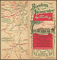
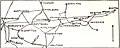 1908 map of streetcar lines between Boston and Worcester.jpg 901 × 364; 101 KB
-
 Consolidated System 1908 map.jpg 3,117 × 2,547; 271 KB
-
 Cover of Boston and Worcester Street Railway brochure.jpg 4,639 × 4,944; 6.95 MB
-
 New Haven electric railway subsidiaries.svg 1,400 × 800; 2.29 MB
-
 Worcester Consolidated Street Railway 1908 map.jpg 1,118 × 1,106; 119 KB
-
 Worcester Consolidated Street Railway Company c 1894.png 2,132 × 1,526; 2.92 MB


