Category:Maps of the Olympic Peninsula
Jump to navigation
Jump to search
Subcategories
This category has only the following subcategory.
O
Media in category "Maps of the Olympic Peninsula"
The following 14 files are in this category, out of 14 total.
-
 118 Sportsman and Tourist Map of Olympic Peninsula, Washington (22133703404).jpg 3,235 × 2,047; 5.06 MB
-

-
 Admiralty Chart No 1792 Port Townsend and Kilisut Harbour, Published 1893.jpg 8,069 × 10,898; 32.09 MB
-
 Image OlympicPeninsulaMap.jpg 258 × 202; 19 KB
-
 Olympic and Kitsap Peninsula Köppen.png 6,000 × 7,800; 386 KB
-
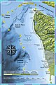 Olympic Coast NMS map 2.jpg 440 × 660; 86 KB
-
 Olympic Coast NMS map.jpg 2,000 × 2,581; 450 KB
-
 Olympic Marmot range.png 587 × 403; 436 KB
-
 Olympicpeninsula.PNG 221 × 136; 3 KB
-
 Raisz 1941 Olympic Peninsula Puget Sound.png 1,241 × 920; 2.02 MB
-
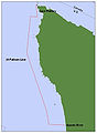 Rockfish fishing 20-fathom range limit.jpg 550 × 748; 24 KB
-
 Washington Maritime NWRC Map en.svg 429 × 603; 351 KB
-
 Washington Maritime NWRC Map.svg 429 × 603; 213 KB
-
 Wpdms nasa topo olympic peninsula.jpg 182 × 312; 19 KB
.jpg)
_(1899)_(19997206773).jpg)


