Category:Maps of the Ohio and Erie Canal
Jump to navigation
Jump to search
Media in category "Maps of the Ohio and Erie Canal"
The following 11 files are in this category, out of 11 total.
-
 Canalvc.png 500 × 459; 73 KB
-
 Columbus Feeder Canal map.jpg 1,242 × 1,330; 334 KB
-
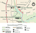
 Cuyahoga Valley National Park map of a portion of the canal route.jpg 5,312 × 2,988; 3.7 MB
-

-

-

-
 Ohio and Erie Canal map.jpg 1,242 × 1,330; 323 KB
-
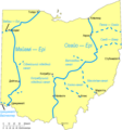
 Ohio and Erie Canal system map captioned.jpg 1,242 × 1,330; 343 KB
-
 Ohio and Erie Canal system map.jpg 1,242 × 1,330; 321 KB
-
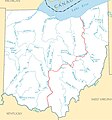
 Ohio Canals Map uk.png 942 × 1,009; 123 KB
-
 Ohio Canals Map.svg 942 × 1,009; 109 KB


