Category:Maps of the Majapahit Empire
Jump to navigation
Jump to search
Media in category "Maps of the Majapahit Empire"
The following 18 files are in this category, out of 18 total.
-
 Administratif Majapahit Kingdom id.png 1,316 × 864; 461 KB
-
 Majapahit Core and Provinces-pt.svg 512 × 228; 372 KB
-
 Majapahit Core and Provinces-sr.svg 512 × 228; 341 KB
-
 Majapahit Core and Provinces.svg 512 × 228; 341 KB
-
 Majapahit Empire de.svg 512 × 297; 520 KB
-
 Majapahit Empire id.svg 512 × 297; 546 KB
-
 Majapahit Empire-es.svg 1,380 × 800; 2.12 MB
-
 Majapahit Empire-pt.svg 512 × 297; 613 KB
-
 Majapahit Empire-sr.svg 512 × 297; 525 KB
-
 Majapahit Empire-zh-hans.svg 512 × 297; 520 KB
-
 Majapahit Empire.svg 512 × 297; 524 KB
-
 Majapahit Expansion.gif 635 × 369; 361 KB
-
 Majapahit Kingdom.jpg 3,264 × 2,787; 1.3 MB
-
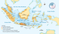
 Map of Majapahit Empire.png 1,600 × 750; 56 KB
-
 Map of the Subordinate Kingdom of Majapahit.png 3,264 × 2,155; 2.9 MB
-
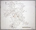
 Plan of Majapahit (BM 1939,0311,0.5.36 1).jpg 2,500 × 2,103; 478 KB
-
 Plan of Majapahit (BM 1939,0311,0.5.36).jpg 1,934 × 1,624; 417 KB
-
 Suhita.png 360 × 160; 36 KB


.jpg)
.jpg)
