Category:Maps of the Labrador Sea
Jump to navigation
Jump to search
Subcategories
This category has only the following subcategory.
M
Media in category "Maps of the Labrador Sea"
The following 5 files are in this category, out of 5 total.
-
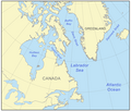
 Labrador Sea in its region.svg 500 × 281; 4.83 MB
-
 Labrador sea map with state labels.png 500 × 426; 189 KB
-
 Labrador sea map.png 500 × 426; 165 KB
-
 Labrador Sea.PNG 756 × 512; 21 KB
-
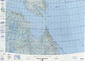 Operational Navigation Chart D-15, 4th edition.jpg 9,254 × 6,666; 16.56 MB


