Category:Maps of the Isle of Raasay
Jump to navigation
Jump to search
English: Maps of the Isle of Raasay, in the civil parish of Portree, in the council area of Highland, Scotland.
Media in category "Maps of the Isle of Raasay"
The following 8 files are in this category, out of 8 total.
-
 Admiralty Chart No 2498 Sound of Raasay and Inner Sound, Published 1961.jpg 12,236 × 8,367; 33.96 MB
-
 Admiralty Chart No 3302 Narrows of Raasay and Caol More, Published 1903.jpg 16,084 × 11,055; 78.63 MB
-
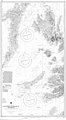 Chart 3674 Southern Approaches to the Minch Scotland.jpg 3,987 × 7,238; 4.72 MB
-
 Ordnance Survey One-Inch Sheet 25 Portree, Published 1956.jpg 8,271 × 9,868; 8.63 MB
-
 Ordnance Survey One-Inch Sheet 25 Raasay & Applecross, Published 1947.jpg 10,459 × 12,911; 11.33 MB
-
 Raasay Inner Hebrides.svg 1,161 × 2,563; 4.35 MB
-
 Raasay.PNG 648 × 584; 19 KB
-
 Raasay.png 433 × 427; 14 KB


