Category:Maps of the Gulf of California
Jump to navigation
Jump to search
English: see also Category:Maps of Baja California peninsula
Media in category "Maps of the Gulf of California"
The following 31 files are in this category, out of 31 total.
-
 1632 Cardona Descripcion Indias (173).jpg 3,136 × 1,568; 384 KB
-
 2009-08-03-Sonora-quake-map-USGS.jpg 600 × 589; 76 KB
-
 2010 Gulf of California earthquake.png 418 × 351; 91 KB
-
 5day track 17E 2006.gif 895 × 716; 21 KB
-
 Admiralty Chart No 2323 Manzanillo Bay to the Gulf of California, Published 1879.jpg 16,333 × 11,089; 43.09 MB
-

-

-
 Admiralty Chart No 2324 Cape St Lucas to San Diego Bay with the Gulf of California, Published 1879.jpg 11,251 × 16,395; 10.56 MB
-

-
 Golf von Kalifornien1.jpg 940 × 1,131; 392 KB
-
 Golftümmler.png 334 × 305; 395 KB
-
 Guaymas Basin and Sonora Margin - gr1 lrg.jpg 2,208 × 1,041; 511 KB
-
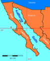
 Gulf of California in its region.svg 500 × 281; 4.83 MB
-
 Gulf of California moisture surge with mts.svg 399 × 410; 195 KB
-
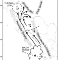 Gulf of California moisture surge.gif 767 × 786; 19 KB
-
 Gulf of California moisture surge.svg 399 × 410; 192 KB
-
 Gulf of California.jpg 4,200 × 5,200; 2.95 MB
-
 Kalifornia Golfo.png 360 × 431; 8 KB
-
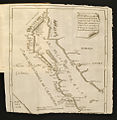 Karta Kalifornije i Baje Californije,Ferdinand Konščak.jpg 470 × 481; 120 KB
-

-
 Representación cartográfica de la isla Montague, Baja California.jpg 1,212 × 841; 61 KB
-
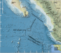 RISE project region.svg 916 × 793; 3.94 MB
-
 Sierra Madres of Mexiko.jpg 1,024 × 722; 209 KB
-
 Mexico - Tiburón Island.PNG 534 × 484; 32 KB
-
 Topographic map of the area around Isla Ángel de la Guarda.png 3,240 × 3,240; 14 MB
-
 Un-Cruise Adventures - Baja's Whale Bounty (itinerary map).jpg 2,250 × 1,453; 1.75 MB
-
 Un-Cruise Adventures - Cousteau's Aquarium of the World (itinerary map).jpg 2,250 × 1,458; 1.78 MB
-
 Un-Cruise Adventures - Isla Esencial - Baja Calif. Sur y Norte (itinerary map).jpg 2,250 × 1,610; 1.41 MB
-
 Un-Cruise Adventures - Milagros Maritimos de Baja Calif. (itinerary map).jpg 2,250 × 1,593; 1.36 MB
-
 Wpdms nasa topo baja california.jpg 315 × 351; 82 KB
-
 Wpdms nasa topo gulf of california.jpg 334 × 305; 76 KB
.jpg)


_(18430121252).jpg)


_(14762212044).jpg)


.jpg)
.jpg)
.jpg)
.jpg)

