Category:Maps of the German Democratic Republic
Jump to navigation
Jump to search
Use the appropriate category for maps showing all or a large part of Germany. See subcategories for smaller areas:
| If the map shows | Category to use |
|---|---|
| Germany on a recently created map | Category:Maps of Germany or its subcategories |
| Germany on a map created more than 70 years ago | Category:Old maps of Germany or its subcategories |
| the history of Germany on a recently created map | Category:Maps of the history of Germany or its subcategories |
| the history of Germany on a map created more than 70 years ago | Category:Old maps of the history of Germany or its subcategories |
This category contains historic maps of the German Democratic Republic (GDR, East Germany). For modern map of eastern Germany see Category:Maps of Germany.
Wikimedia category | |||||
| Upload media | |||||
| Instance of | |||||
|---|---|---|---|---|---|
| Category combines topics | |||||
| German Democratic Republic | |||||
1949–1990 country in central Europe, unified into modern Germany   Coat of arms of East Germany  Location of the German Democratic Republic within Europe  | |||||
| Spoken text audio | |||||
| Instance of |
| ||||
| Location |
| ||||
| Capital | |||||
| Basic form of government |
| ||||
| Legislative body | |||||
| Executive body | |||||
| Official language | |||||
| Anthem |
| ||||
| Currency |
| ||||
| Head of state |
| ||||
| Head of government |
| ||||
| Inception |
| ||||
| Dissolved, abolished or demolished date |
| ||||
| Population |
| ||||
| Area |
| ||||
| Followed by | |||||
| Replaces |
| ||||
| Replaced by | |||||
| Top-level Internet domain |
| ||||
 | |||||
Subcategories
This category has the following 17 subcategories, out of 17 total.
Media in category "Maps of the German Democratic Republic"
The following 43 files are in this category, out of 43 total.
-
 2013 OpenDataCity Handelsblatt-Data NSA Stasi ZoomIn.png 930 × 620; 478 KB
-
 2013 OpenDataCity Handelsblatt-Data NSA Stasi ZoomOut.png 930 × 620; 243 KB
-
 20190530 Dresden - Die Welt der DDR - 042.jpg 2,736 × 3,648; 2.25 MB
-
 20190530 Dresden - Die Welt der DDR - 043.jpg 2,736 × 3,648; 2.18 MB
-
 Allied Access Routes to West Berlin - DPLA - 58e9514df54c04c423c5829727d0ff08.jpg 2,396 × 3,118; 6.96 MB
-
 Alpina-Baustellen.jpg 1,516 × 1,820; 289 KB
-
 Approaches to Berlin (Germany) - DPLA - 555730a5be729d035c73f613efaa79ec.jpg 2,714 × 3,448; 8.29 MB
-
 Ard-reichweite-ddr.png 805 × 1,024; 160 KB
-
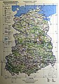 Beispiel einer Topographischen Karten-Ausgabe für die Volkswirtschaft TK(AV).jpg 3,371 × 4,806; 4.97 MB
-
 Bild-LuftkorridoreBerlin1989.jpg 2,790 × 1,860; 1.5 MB
-

-

-

-
 Corridoi-aerei-Berlino.jpg 349 × 514; 109 KB
-
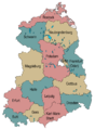
 DDR Bezirk.png 434 × 620; 82 KB
-
 DDR Grenzuebergangstelle 1982.png 1,000 × 1,371; 437 KB
-
 DDR Verwaltung 060415.png 1,500 × 2,036; 205 KB
-
 DDR Verwaltung.png 1,500 × 2,036; 44 KB
-
 DDR Verwaltung2.png 1,500 × 2,036; 203 KB
-
 DDR-Straßenmeister 1959.jpg 530 × 629; 43 KB
-
 Denkmal Südgrenze des skandinavischen Inlandseises im Quartär (Blankenburg).jpg 3,000 × 3,267; 3.21 MB
-
 Deutsches Reich DDR Karte.png 593 × 681; 861 KB
-
 Dialekte in der DDR.png 1,161 × 1,500; 450 KB
-

-
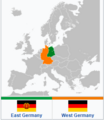 East and West Germany with color-coded title.png 274 × 317; 33 KB
-
 East Germany- Administrative divisions-June 1957. 5-58. LOC 75693376.tif 6,592 × 8,424; 158.88 MB
-
 East Germany-CIA WFB Map.png 686 × 684; 486 KB
-
 East Germany. 7-69. LOC gm70003117.tif 3,156 × 4,159; 37.55 MB
-
 East Germany. 7-69. LOC gm70003152.tif 3,154 × 4,224; 38.12 MB
-
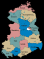
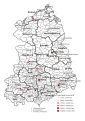 Gebietseinteilung der DDR in Bezirke und Kreise 1989.svg 744 × 1,052; 3.16 MB
-
 Germany and Poland borders during the 20th century Wlegend.png 500 × 711; 66 KB
-
 Germany Laender 1947 1990 DDR.png 444 × 612; 16 KB
-
 GreifenTitel.jpg 454 × 584; 56 KB
-
 Grenznaher Verkehr040.jpg 1,160 × 2,243; 652 KB
-
 Landstreitkräfte.jpg 525 × 701; 68 KB
-
 Luftstreitkräfte.jpg 525 × 692; 72 KB
-
 MEK 3.0-6488.jpg 4,256 × 3,499; 12.17 MB
-
 RDA-Districts-administratifs.png 427 × 599; 105 KB
-
 RIAS audibility.png 350 × 477; 16 KB
-
 Silhouette of East Germany.svg 900 × 1,293; 95 KB
-
 Soviet Zone- Germany Police Organization - DPLA - 8171351128b29df57feefbb775586b61.jpg 4,678 × 4,746; 2.44 MB
-
 Trans pride East Germany.jpg 643 × 924; 118 KB
-
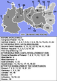
 World Factbook (1990) German Democratic Republic.jpg 590 × 575; 128 KB


_-_DPLA_-_555730a5be729d035c73f613efaa79ec.jpg)

.jpg)


_-_DPLA_-_300cd9b1e41063d660ab3e0e34983058.jpg)


_German_Democratic_Republic.jpg)
.jpg)