Category:Maps of the Eider
Jump to navigation
Jump to search
Deutsch: Die Eider (lateinisch Egdor; altnordisch Egða; dänisch Ejderen) ist mit 188 Kilometern der längste Fluss in Schleswig-Holstein. Von 811 bis 1864 markierte der Fluss mit einigen Unterbrechungen die Südgrenze Dänemarks.
English: The Eider (German: Die Eider; Danish: Ejderen; Latin: Egdor or Egdore) is the longest river of the German state of Schleswig-Holstein. The river starts near Bordesholm and reaches the southwestern outskirts of Kiel on the shores of the Baltic Sea, but flows to the west, ending in the North Sea. The middle part of the Eider was appropriated for use as part of the Kiel Canal.
Media in category "Maps of the Eider"
The following 8 files are in this category, out of 8 total.
-

-
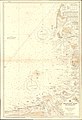 Admiralty Chart No 3347 Helgoland Bight and approaches, Published 1919.jpg 11,130 × 16,241; 45.9 MB
-
 De Nordseeküste (Karten) 05.jpg 6,182 × 4,412; 3.88 MB
-
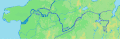 Eider Flussverlauf.gif 728 × 239; 77 KB
-
 Eider Treene2.gif 1,244 × 1,024; 104 KB
-
 Nordens Historie - Sønderjylland.gif 600 × 596; 190 KB
-
 Pflanzen und Tiere im Eidertal.jpg 3,648 × 2,736; 2.92 MB
-
 Sorge (Eider).gif 1,244 × 1,024; 102 KB
.jpg)

_05.jpg)


.gif)