Category:Maps of submarine volcanoes in the Pacific Ocean
Jump to navigation
Jump to search
Media in category "Maps of submarine volcanoes in the Pacific Ocean"
The following 22 files are in this category, out of 22 total.
-
 Bathymetry around Farallon de Pajaros.jpg 596 × 405; 113 KB
-
 British Columbia submarine volcanoes.jpg 692 × 572; 77 KB
-
 Colosseum Guyot, Tamu Massif.png 1,770 × 769; 2.01 MB
-
 Ecoregion AA0113.png 1,172 × 1,172; 1.45 MB
-
 EmperorSeamounts.jpg 900 × 600; 367 KB
-
 Esmeralda 3d hires.jpg 2,724 × 2,029; 2.07 MB
-
 Expl0049 - Flickr - NOAA Photo Library.jpg 3,240 × 2,283; 690 KB
-
 Galapagos Bathymetric.jpg 792 × 612; 152 KB
-
 Gulf of Alaska seamounts.jpg 600 × 450; 34 KB
-
 Kermadec Arc.jpg 585 × 897; 172 KB
-
 Kodiak-Bowie Seamounts.jpg 600 × 365; 57 KB
-
 Louisville seamount chain - bathymetry.jpg 738 × 521; 212 KB
-
 Magic Mountain map.jpg 525 × 776; 121 KB
-
 Maug caldera bathymetry.jpg 3,693 × 2,250; 673 KB
-
 Minami Kasuga.jpg 640 × 480; 46 KB
-
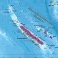
 New Caledonia and Vanuatu bathymetric and topographic map-mk.svg 2,980 × 2,090; 4.32 MB
-
 Ruby 3d hires.jpg 2,724 × 2,029; 2 MB
-
 Ruby bathymetry map 600.jpg 600 × 639; 89 KB
-
 SeamontDavidson expedition bathymetric-2002.jpg 600 × 478; 59 KB
-
 Smnx frcast map hires.jpg 2,160 × 2,757; 2.4 MB
-
 TamuMassifHe.jpg 900 × 600; 259 KB
-
 Zealandia 3d hires.jpg 2,721 × 2,029; 1.99 MB


