Category:Maps of national parks of Spain
Jump to navigation
Jump to search
Countries of Europe: France‡ · Iceland · Italy · Netherlands‡ · Norway · Poland · Spain‡
‡: partly located in Europe
‡: partly located in Europe

Subcategories
This category has only the following subcategory.
M
Media in category "Maps of national parks of Spain"
The following 11 files are in this category, out of 11 total.
-
 NASA Satellite Limits of Parc Nacional Aiguestortes.jpg 410 × 400; 43 KB
-
 Locator map of Aiguestortes.png 240 × 234; 30 KB
-
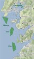 Map National Park Atlantic Island of Galicia.tif 425 × 734; 942 KB
-
 Oriental San mauricio.jpg 2,637 × 2,826; 620 KB
-
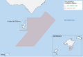 Parc national de l'Archipel de Cabrera.svg 512 × 348; 164 KB
-
 Parques Nacionales de España 2017.png 2,232 × 1,764; 121 KB
-
 Parques Nacionales de España.png 2,220 × 1,532; 839 KB
-
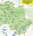
 Parques Nacionales y Naturales de Cantabria.png 1,518 × 925; 910 KB
-
 Parques Naturales y Nacionales de Cantabria.png 1,167 × 734; 583 KB
-
 Teide national park map (fr).svg 1,052 × 673; 5.52 MB
-
 VallesanNicolau.jpg 4,332 × 2,804; 1.89 MB


.svg)
