Category:Maps of municipalities of Guatemala
Jump to navigation
Jump to search
Subcategories
This category has the following 8 subcategories, out of 8 total.
C
- Maps of Cobán (2 F)
E
- Maps of Escuintla (1 F)
H
- Maps of Huehuetenango (1 F)
M
P
- Maps of Puerto Barrios (1 F)
Q
- Maps of Quetzaltenango (2 F)
S
V
- Maps of Villa Nueva (Guatemala) (30 F)
Media in category "Maps of municipalities of Guatemala"
The following 11 files are in this category, out of 11 total.
-
 Densidad Poblacional de Guatemala 2018.png 3,507 × 2,480; 989 KB
-
 Guatemala municipalities.png 1,281 × 878; 42 KB
-
 Map of Guatemala.svg 1,183 × 1,239; 2.38 MB
-
 Mapa Autopista VAS - Via Alterna del Sur Guatemala.png 6,000 × 4,885; 33.67 MB
-
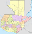
 Mapa de Guatemala (subdivisiones).svg 1,183 × 1,239; 2.27 MB
-
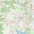
 Mapa de las principales carreteras en Villa Nueva, Guatemala.png 5,000 × 6,680; 16.17 MB
-
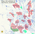 Mapa de las zonas mas pobladas de Villa Nueva Guatemala.png 9,654 × 9,256; 57.66 MB
-
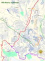
 Mapa de Villa Nueva, Guatemala.png 5,000 × 5,059; 15.08 MB
-
 Mapa del Area Metropolitana de Guatemala AMG.png 9,000 × 9,251; 68.03 MB
-
 MAPA MUNICIPIO DE JUTIAPA.jpg 1,694 × 1,019; 397 KB
-
 Municipio de Jutiapa, Guatemala.png 640 × 454; 467 KB


.svg)


