Category:Maps of local municipalities of Limpopo
Jump to navigation
Jump to search
Media in category "Maps of local municipalities of Limpopo"
The following 22 files are in this category, out of 22 total.
-
 Map of Limpopo with Ba-Phalaborwa highlighted (2016).svg 925 × 621; 395 KB
-
 Map of Limpopo with Bela-Bela highlighted (2016).svg 925 × 621; 387 KB
-
 Map of Limpopo with Blouberg highlighted (2016).svg 925 × 621; 390 KB
-
 Map of Limpopo with Collins Chabane highlighted (2016).svg 925 × 621; 398 KB
-
 Map of Limpopo with Elias Motsoaledi highlighted (2016).svg 925 × 621; 387 KB
-
 Map of Limpopo with Ephraim Mogale highlighted (2016).svg 925 × 621; 387 KB
-
 Map of Limpopo with Fetakgomo Greater Tubatse highlighted (2016).svg 925 × 621; 391 KB
-
 Map of Limpopo with Greater Giyani highlighted (2016).svg 925 × 621; 399 KB
-
 Map of Limpopo with Greater Letaba highlighted (2016).svg 925 × 621; 383 KB
-
 Map of Limpopo with Greater Tzaneen highlighted (2016).svg 925 × 621; 386 KB
-
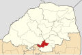
 Map of Limpopo with Lepelle-Nkumpi highlighted (2016).svg 925 × 621; 391 KB
-
 Map of Limpopo with Lephalale highlighted (2016).svg 925 × 621; 414 KB
-
 Map of Limpopo with Makhado highlighted (2016).svg 925 × 621; 390 KB
-
 Map of Limpopo with Makhuduthamaga highlighted (2016).svg 925 × 621; 387 KB
-
 Map of Limpopo with Maruleng highlighted (2016).svg 925 × 621; 386 KB
-
 Map of Limpopo with Modimolle Mookgophong highlighted (2016).svg 925 × 621; 390 KB
-
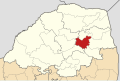
 Map of Limpopo with Mogalakwena highlighted (2016).svg 925 × 621; 390 KB
-
 Map of Limpopo with Molemole highlighted (2016).svg 925 × 621; 385 KB
-
 Map of Limpopo with Musina highlighted (2016).svg 925 × 621; 411 KB
-
 Map of Limpopo with Polokwane highlighted (2016).svg 925 × 621; 385 KB
-
 Map of Limpopo with Thabazimbi highlighted (2016).svg 925 × 621; 403 KB
-
 Map of Limpopo with Thulamela highlighted (2016).svg 925 × 621; 395 KB
.svg)
.svg)
.svg)
.svg)
.svg)
.svg)
.svg)
.svg)
.svg)
.svg)
.svg)
.svg)
.svg)
.svg)
.svg)
.svg)
.svg)
.svg)
.svg)
.svg)
.svg)
.svg)