Category:Maps of districts of Zambia till 2016
Jump to navigation
Jump to search
Media in category "Maps of districts of Zambia till 2016"
The following 11 files are in this category, out of 11 total.
-
 Districts of Copperbelt Province Zambia.svg 519 × 465; 463 KB
-
 Districts of Eastern Province Zambia.svg 519 × 465; 502 KB
-
 Districts of Luapula Province Zambia.svg 519 × 465; 486 KB
-
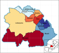
 Districts of Lusaka Province Zambia.svg 519 × 465; 400 KB
-
 Districts of Muchinga Province Zambia.svg 519 × 465; 577 KB
-
 Districts of North-Western Province Zambia.svg 519 × 465; 673 KB
-
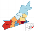
 Districts of Northern Province Zambia.svg 519 × 465; 581 KB
-
 Districts of Southern Province Zambia.svg 519 × 465; 541 KB
-
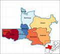
 Districts of Western Province Zambia.svg 519 × 465; 616 KB
-
 Maps of Zambias Districts 2.png 4,134 × 3,543; 243 KB
-
 Provincial Districts of Zambia Transparent.svg 519 × 465; 2.31 MB


