Category:Maps of city walls in Germany
Jump to navigation
Jump to search
Media in category "Maps of city walls in Germany"
The following 10 files are in this category, out of 10 total.
-
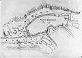 Plan Gernsbach 1689.jpg 990 × 700; 282 KB
-
 Schmalkalder Gernsbach.jpg 400 × 284; 36 KB
-
 Herrenberg, Auf dem Graben, Stadtmauer, Tafel.jpg 2,409 × 1,974; 1.84 MB
-
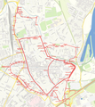
 Ladenburg-Stadtmauer.png 1,015 × 769; 750 KB
-
 Boeckh Ravensburg aus der Vogelschau 1616 Detail Oberstadt.jpg 3,950 × 3,044; 4.34 MB
-
 Boeckh Ravensburg aus der Vogelschau 1616.jpg 4,174 × 5,521; 6.42 MB
-
 Karte Stadtbefestigung Speyer mit ältester Mauer.png 2,315 × 2,597; 3.43 MB
-
 Karte Stadtbefestigung Speyer.png 2,315 × 2,597; 3.42 MB
-
 Speyer Stadtplan 1730.jpg 2,360 × 1,500; 762 KB
-
 Ulm 1597.jpg 3,507 × 1,904; 3.39 MB


