Category:Maps of boundary between Europe and Asia
Jump to navigation
Jump to search
Media in category "Maps of boundary between Europe and Asia"
The following 29 files are in this category, out of 29 total.
-
 1861 Johnson Map of Asia - Geographicus - Asia-johnson-1861.jpg 3,000 × 2,507; 2.78 MB
-

-

-
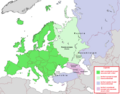
 Asia Europe transcontinental.png 1,268 × 996; 46 KB
-
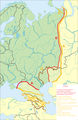
 Boundary between Europe and Asia (green shade).png 735 × 1,134; 163 KB
-
 Confini Europa-Asia.png 735 × 1,134; 212 KB
-
 Different versions of the Europe-Asia border.png 309 × 562; 75 KB
-
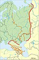 Eurasian borders.jpg 735 × 1,134; 557 KB
-
 Europa - stati transcontinentali.png 1,268 × 996; 78 KB
-
 Europa suddivisa in dodici regioni.png 1,360 × 1,040; 331 KB
-
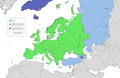
 Europe Asia transcontinental.png 1,268 × 996; 47 KB
-
 Europe subregion map UN geoscheme.svg 680 × 520; 228 KB
-
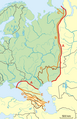
 Europe-Asia border (geographic).png 1,000 × 743; 40 KB
-
 European Part of Soviet Union location map.png 1,580 × 2,048; 894 KB
-
 Historical Europe-Asia boundaries 1700 to 1900.png 309 × 562; 75 KB
-
 Historical map of Russian, 862.gif 1,800 × 2,207; 1.8 MB
-
 Johnson, A.J. Europe. 1864.B.jpg 2,393 × 1,630; 1,004 KB
-
 Le varie convenzioni sul confine Europa-Asia.png 729 × 1,129; 192 KB
-
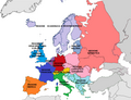
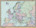
 Map of Europe (political).png 1,596 × 1,043; 86 KB
-
 Map of Europe, according to various definitions.jpg 2,560 × 1,958; 1.22 MB
-
 Map of Europe, its countries, and neighbors.png 4,013 × 3,158; 17.53 MB
-
 Monumenti sul confine Europa-Asia.jpg 1,678 × 1,967; 889 KB
-
 Possible definitions of the boundary between Europe and Asia.png 729 × 1,129; 207 KB
-
 Russia physical location map (with boundary between Europe and Asia).jpg 1,280 × 820; 606 KB
-
 Standard map of Europe (blank).png 700 × 545; 152 KB
-
 Stati d'Europa secondo i vari criteri.png 1,268 × 996; 94 KB
-
 The Border between Europe and Asia in Azerbaijan, T. Letss (1883).jpg 971 × 591; 499 KB
-
 TransAsia.PNG 424 × 919; 12 KB
-
 Европа-Азия (граница).png 1,200 × 1,043; 244 KB

%27_(11171321265).jpg)
%27_(11171504526).jpg)
.png)


.png)


.png)


.jpg)

.jpg)
.png)
.png)