<nowiki>Category:Maps of Zeevang; categoría de Wikimedia; Wikimedia-Kategorie; 维基媒体分类; катэгорыя ў праекце Вікімэдыя; Wikimedia-kategori; د ويکيمېډيا وېشنيزه; kategori e Wikimedias; Vikipidiya:Shopni; kategori Wikimedia; categorie în cadrul unui proiect Wikimedia; Wikimedia-categorie; Wikimedia-kategory; Wikimedia category; Wikimedia:Klassys; категория на Уикимедия; jamii ya Wikimedia; Vikimedya kategorisi; 維基媒體分類; หน้าหมวดหมู่วิกิมีเดีย; ویکیمیڈیا زمرہ; kategória projektov Wikimedia; Wikimedia proyektındağı törkem; категорія проєкту Вікімедіа; kawan Wikimèdia; 維基媒體分類; 维基媒体分类; Wikimedia-Kategorie; 위키미디어 분류; Wikimedia-bólkur; kategorio en Vikimedio; kategori Wikimedia; kategorija na Wikimediji; categoría de Wikimedia; উইকিমিডিয়া বিষয়শ্রেণী; page de catégorie de Wikimedia; kategori Wikimedia; kategorija na Wikimediji; Wikimedia-categorie; 维基媒体分类; Викимедиа категорияһы; Викимедиина категорија; विकिपीडिया वर्ग; kategorija w projektach Wikimedije; thể loại Wikimedia; विकिपीडिया:श्रेणी; Wikimedia projekta kategorija; kategoria ti Wikimedia; категорија на Викимедији; Kategoriya ning Wikimedia; гурӯҳи Викимедиа; categoria de um projeto da Wikimedia; Wikimedia category; категорияд Ангилал; Wikimedia-kategori; Wikimedia-kategori; kategori Wikimédia; kategori Wikimedia; 维基媒体分类; Wikimedia-kategori; پۆلی ویکیمیدیا; Wikimedia category; تصنيف ويكيميديا; pajenn rummata eus Wikimedia; Wikimedia-Kategorie; Wikimedia:ကဏ္ဍခွဲခြင်း; 維基媒體分類; Wikimedia категориясы; વિકિપીડિયા શ્રેણી; Vikimédia ñemohenda; Wikimediako kategoria; categoria de Wikimedia; categoría de Wikimedia; Wikimedia-Kategorie; Wikimedia-Kategorie; tudalen categori Wikimedia; categoria Vicimediorum; катэгорыя ў праекце Вікімедыя; ردهٔ ویکیپدیا; Wikimedia-kategorie; Wîkîmediya:Kategorî; विकिमिडिया श्रेणी; ウィキメディアのカテゴリ; categoria Wikimedia; categurìa 'e nu pruggette Wikimedia; تصنيف بتاع ويكيميديا; Wikimedia kategooria; විකිමීඩියා ප්රභේද පිටුව; Викимедиа проектындагы төркем; Wikimedia-Kategorie; विकिमीडिया श्रेणी; категория в проекте Викимедиа; Wikimedia-kategoriija; гурӯҳ дар лоиҳаи Викимедиа; Wikimedia category; 維基媒體分類; விக்கிமீடியப் பகுப்பு; categoria di un progetto Wikimedia; gurühi Vikimedia; ვიკიპედია:კატეგორიზაცია; Wikimedia-categorie; 維基媒體分類; Wikimedia-luokka; Викимедиа проектындагы төркем; דף קטגוריה; 维基媒体分类; ẹ̀ka Wikimedia; catigurìa di nu pruggettu Wikimedia; categoria de um projeto da Wikimedia; Վիքիմեդիայի նախագծի կատեգորիա; Viciméid catagóir; tumbung Wikimedia; Wikimedia-Kategorie; kategorija Wikimedie; kategorya ng Wikimedia; Wikimédia-kategória; विकिमिडिया श्रेणी; kategori Wikimedia; kategoria w projekcie Wikimedia; വിക്കിമീഡിയ വർഗ്ഗം; Wikimedia:Kategorija; kategori Wikimedia; Wikimedia:Ronnaghys; زمرو:وڪيپيڊيا زمرا بندي; Wikimedia-Kategorie; categoría de Wikimedia; kategorie na projektech Wikimedia; κατηγορία εγχειρημάτων Wikimedia; Wikimedia-kategorie</nowiki>
Subcategories
This category has the following 6 subcategories, out of 6 total.


.svg)

 2013-Zeevang.jpg 1,826 × 2,112; 2.03 MB
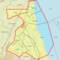 BAG woonplaatsen - Gemeente Zeevang.png 2,419 × 2,419; 414 KB
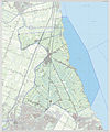 Gem-Zeevang-2014Q1.jpg 3,555 × 4,263; 5.72 MB
 Gem-Zeevang-OpenTopo.jpg 4,431 × 5,222; 7.62 MB
 LocationZeevang.png 421 × 196; 40 KB
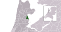 Map - NL - Municipality code 0478 (2014).png 2,000 × 1,067; 221 KB
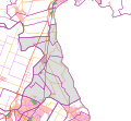 Map - NL - Zeevang (2009).svg 625 × 575; 1.46 MB
 Map NL - Zeevang - Beets.png 800 × 600; 7 KB
 Map NL - Zeevang - Hobrede.png 800 × 600; 6 KB
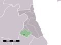 Map NL - Zeevang - Kwadijk.png 800 × 600; 7 KB
 Map NL - Zeevang - Middelie.png 800 × 600; 6 KB
 Map NL - Zeevang - Oosthuizen.png 800 × 600; 7 KB
 Map NL - Zeevang - Schardam.png 800 × 600; 6 KB
 Map NL - Zeevang - Warder.png 800 × 600; 6 KB


.png)
.svg)


