Category:Maps of Turkestan
Jump to navigation
Jump to search
Subcategories
This category has only the following subcategory.
M
Media in category "Maps of Turkestan"
The following 17 files are in this category, out of 17 total.
-
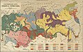 1890 map of ethnic groups in Russia by Brockhaus.jpg 5,764 × 3,594; 6.44 MB
-
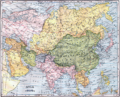 1904 map of Asia.png 3,927 × 3,172; 32.7 MB
-
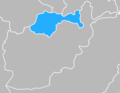
 AfghanTurkestan.png 800 × 589; 154 KB
-
 Central Asia Ethnic en.svg 512 × 322; 762 KB
-
 Central Asia Ethnic es.svg 2,392 × 1,504; 1.27 MB
-
 Cnt asia cia1.jpg 787 × 697; 138 KB
-
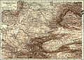 EB1911 Turkestan.jpg 2,465 × 1,758; 1.93 MB
-
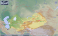
 Governorate-General of Turkestan.png 3,000 × 1,973; 1.06 MB
-
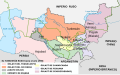
 Gunota turkestan map.png 1,774 × 1,379; 174 KB
-
 Map of Turkestan as defined by Britannica (2011).png 1,155 × 744; 1.09 MB
-
 Map of Turkestan as defined by Britannica.png 1,155 × 744; 1.09 MB
-
 Turkestan 1900-es.svg 2,393 × 1,485; 374 KB
-
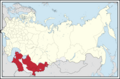
 Turkestan autonomous.png 1,600 × 1,037; 162 KB
-
 Turkestan.png 1,253 × 781; 1.28 MB
-
 Türk Ülkeleri haritasi.jpg 1,753 × 1,141; 119 KB
-
 Туркестан 1918.png 1,156 × 727; 239 KB
-
 خريطة تركستان الشرقية و الغربية.png 300 × 236; 50 KB


.png)


