Category:Maps of Trentino-South Tyrol
Jump to navigation
Jump to search
- Regions of Italy: Abruzzo · Aosta Valley · Apulia · Basilicata · Calabria · Campania · Emilia-Romagna · Friuli-Venezia Giulia · Lazio · Liguria · Lombardy · Marche · Molise · Piedmont · Sardinia · Sicily · Trentino-South Tyrol · Tuscany · Umbria · Veneto
Wikimedia category | |||||
| Upload media | |||||
| Instance of | |||||
|---|---|---|---|---|---|
| Category combines topics | |||||
| Trentino-South Tyrol | |||||
autonomous region in Northern Italy  someja satełitar in zenaro    | |||||
| Instance of |
| ||||
| Location | Italy | ||||
| Capital | |||||
| Legislative body |
| ||||
| Executive body |
| ||||
| Official language | |||||
| Head of government |
| ||||
| Has part(s) | |||||
| Population |
| ||||
| Area |
| ||||
| Elevation above sea level |
| ||||
| official website | |||||
 | |||||
Use the appropriate category for maps showing all or a large part of Trentino-South Tyrol. See subcategories for smaller areas:
| If the map shows | Category to use |
|---|---|
| Trentino-South Tyrol on a recently created map | Category:Maps of Trentino-South Tyrol or its subcategories |
| Trentino-South Tyrol on a map created more than 70 years ago | Category:Old maps of Trentino-South Tyrol or its subcategories |
| the history of Trentino-South Tyrol on a recently created map | Category:Maps of the history of Trentino-South Tyrol or its subcategories |
| the history of Trentino-South Tyrol on a map created more than 70 years ago | Category:Old maps of the history of Trentino-South Tyrol or its subcategories |

Subcategories
This category has the following 14 subcategories, out of 14 total.
B
C
E
M
R
S
Pages in category "Maps of Trentino-South Tyrol"
This category contains only the following page.
Media in category "Maps of Trentino-South Tyrol"
The following 30 files are in this category, out of 30 total.
-
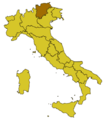
 Italy Regions Trentino Map.png 220 × 257; 18 KB
-
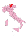
 ItalyTrentino-AltoAdige.png 269 × 314; 5 KB
-
 TAA-Mappa.png 300 × 350; 5 KB
-
 Alto Adige in history-de.png 2,337 × 1,990; 402 KB
-
 Alto Adige in history.png 750 × 640; 38 KB
-
 Autonomous Regions of Italy.jpg 566 × 494; 25 KB
-
 Autonomous Regions of Italy.svg 735 × 867; 118 KB
-
 Circoscrizione Trentino-Alto Adige (Camera dei Deputati).png 1,632 × 2,112; 122 KB
-
 Comuni e data di cambio provincia.jpg 526 × 420; 113 KB
-
 Friulano & Co..JPG 847 × 623; 70 KB
-
 Giro del Trentino 2011.png 622 × 634; 763 KB
-
 Ladinia towns.gif 1,028 × 686; 32 KB
-
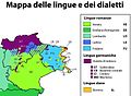
 Linguistic map of Northeast Italy.png 770 × 314; 94 KB
-
 Map Cultural heritage and environment II 1992 - Touring Club Italiano CART-TEM-113.jpg 5,000 × 3,419; 12.42 MB
-
 Mappa localizzazione giardino d'Europa De Gasperi 01.png 974 × 581; 312 KB
-
 Mappa localizzazione giardino d'Europa De Gasperi.png 974 × 581; 191 KB
-
 Parco-Stelvio-Posizione.png 269 × 313; 36 KB
-
 Regione thumb Trentino-Alto Adige.svg 188 × 191; 463 KB
-
 RGLS15.jpg 442 × 282; 44 KB
-
 Sprachen in der Europaregion Tirol-Südtirol-Trentino.png 1,234 × 941; 1.05 MB
-
 Trentino-Alto Adige in Italy (+provinces).svg 1,034 × 1,299; 3 MB
-
 Trentino-Alto Adige in Italy.svg 1,034 × 1,299; 1.67 MB
-
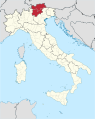
 Trentino-South Tyrol in Italy.svg 1,034 × 1,299; 1.81 MB
-
 Trentino-Sudtirol-DEN.jpg 1,500 × 1,621; 293 KB
-
 Trentino-Sudtirol-POP.jpg 1,500 × 1,621; 298 KB
-
 Trentino-Sudtirol-VAR.jpg 1,500 × 1,621; 295 KB
-
 Triveneto-fr.svg 720 × 643; 102 KB
-
 Triveneto.svg 720 × 643; 86 KB
-
 Tyrol and Trent 1800.jpg 2,048 × 1,764; 3.57 MB
-
 Venezie.PNG 1,169 × 826; 1.45 MB


.png)


.svg)


