Category:Maps of Stuttgart
Jump to navigation
Jump to search
Urban districts (cities): Baden-Baden · Freiburg · Heidelberg · Heilbronn · Karlsruhe · Mannheim · Pforzheim · Stuttgart · Ulm
Use the appropriate category for maps showing all or a large part of Stuttgart. See subcategories for smaller areas:
| If the map shows | Category to use |
|---|---|
| Stuttgart on a recently created map | Category:Maps of Stuttgart or its subcategories |
| Stuttgart on a map created more than 70 years ago | Category:Old maps of Stuttgart or its subcategories |
| the history of Stuttgart on a recently created map | Category:Maps of the history of Stuttgart or its subcategories |
| the history of Stuttgart on a map created more than 70 years ago | Category:Old maps of the history of Stuttgart or its subcategories |
Wikimedia category | |||||
| Upload media | |||||
| Instance of | |||||
|---|---|---|---|---|---|
| Category combines topics | |||||
| Stuttgart | |||||
capital of the federal state Baden-Württemberg, Germany       | |||||
| Pronunciation audio | |||||
| Instance of |
| ||||
| Part of | |||||
| Named after | |||||
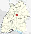
| Location | Stuttgart Government Region, Baden-Württemberg, Germany | ||||
| Located in or next to body of water | |||||
| Visitor center | |||||
| Legislative body | |||||
| Head of government |
| ||||
| Legal form | |||||
| Highest point | |||||
| Population |
| ||||
| Area |
| ||||
| Elevation above sea level |
| ||||
| Budget |
| ||||
| Different from | |||||
| official website | |||||
 | |||||
Subcategories
This category has the following 9 subcategories, out of 9 total.
- OpenStreetMap maps of Stuttgart (15 F)
*
- Tram maps of Stuttgart (5 F)
C
- Maps of cemeteries in Stuttgart (15 F)
E
- Election maps of Stuttgart (4 F)
K
L
P
- Plans of Wilhelma Zoo (7 F)
S
- Stadtkarte Stuttgart 1:1000 (9 F)
Pages in category "Maps of Stuttgart"
This category contains only the following page.
Media in category "Maps of Stuttgart"
The following 123 files are in this category, out of 123 total.
-
-
 101 of 'Bilder aus Alt-Stuttgart ... Mit Text versehen' (11235762855).jpg 2,451 × 3,308; 1.75 MB
-
 103 of 'Camping Voyages on German Rivers, etc' (11206135425).jpg 1,204 × 2,028; 347 KB
-
-
 1575 H Schweickher Amt Stuttgart WLB 00000017.jpg 1,436 × 953; 1.37 MB
-
 158 of 'Bilder aus Alt-Stuttgart ... Mit Text versehen' (11236122984).jpg 2,555 × 3,530; 2.84 MB
-
 1600 Stuttgarter Beamptung LABW HStA Stuttgart N 1 Nr. 70 Bild 3.jpg 1,587 × 1,252; 2.46 MB
-
 162 of 'Bilder aus Alt-Stuttgart ... Mit Text versehen' (11235630324).jpg 2,492 × 3,530; 3.03 MB
-
 163 of 'Bilder aus Alt-Stuttgart ... Mit Text versehen' (11234389414).jpg 2,056 × 3,533; 2.25 MB
-
 Alte Stuttgart-Pläne, 003.jpg 4,131 × 4,333; 8.03 MB
-
 Seutter Stutgardia Würtenbergensis Ducatus Metropolis, Ausschnitt mit Hauptstätte.jpg 2,826 × 1,854; 5.06 MB
-
 Seutter Stutgardia Würtenbergensis Ducatus Metropolis, mit Suchhilfe.jpg 4,564 × 3,918; 20.75 MB
-
 Seutter Stutgardia Würtenbergensis Ducatus Metropolis.jpg 4,564 × 3,918; 20.44 MB
-
 Karte Stuttgart.png 567 × 532; 113 KB
-
 275 of 'Chronik der Stadt Stuttgart, etc' (11183608475).jpg 2,400 × 1,690; 1.22 MB
-
 Alte Stuttgart-Pläne, 005.jpg 5,120 × 4,532; 10.04 MB
-
 Britannica Stuttgart - Environs.jpg 665 × 1,093; 228 KB
-
 Britannica Stuttgart - Plan.jpg 1,262 × 1,201; 532 KB
-
 Charte von Schwaben Tafel 13 Stuttgart.jpg 2,164 × 2,655; 4.27 MB
-
 Einteilung der Armenarzt-Bezirke von Stuttgart nach dem Stand vom 1. Januar 1898.jpg 9,518 × 6,364; 38.64 MB
-
 Erlöserkirche Stuttgart, Lageplan.jpg 525 × 709; 280 KB
-
 Fisierung zum Seewasen zu Stuttgart.jpg 370 × 404; 52 KB
-
 Grundriss der ersten Königlichen Residenz und Hauptstadt Stuttgart (1827).jpg 6,164 × 5,321; 6.76 MB
-

-
 Historische Ansichten von Stuttgart, 001.jpg 1,457 × 516; 441 KB
-
 Historische Ansichten von Stuttgart, 002.jpg 4,402 × 883; 3.81 MB
-
 Hohenheim-gartenplan.jpg 800 × 595; 99 KB
-
 J Sauter - Ansicht von Stuttgart Radierung 1592 (GdSS1-n352).jpg 8,272 × 3,327; 18.3 MB
-
 J Sauter - Ansicht von Stuttgart Radierung 1592 - Autographie von Max Bach 1870.jpg 6,178 × 1,785; 7.33 MB
-
 J Sauter - Ansicht von Stuttgart Radierung 1592 mit Legende (GdSS1-n352).jpg 8,272 × 3,327; 18.29 MB
-
 Kantstadt. Der würtembergische Fuss = 1250 Theile (1 - 1 250 ) - btv1b53102598c.jpg 9,163 × 7,370; 13.17 MB
-
 Karte s innen.png 115 × 109; 3 KB
-
 Karte Stuttgart in Deutschland.png 188 × 235; 5 KB
-
 Katharinenhospital, 017.jpg 1,647 × 2,152; 1.24 MB
-
 Katharinenhospital, 018.jpg 3,770 × 2,506; 4.34 MB
-
 Katharinenhospital, 012.jpg 1,552 × 864; 1.09 MB
-
 Katharinenhospital, 013.jpg 830 × 579; 414 KB
-
 Katharinenhospital, 014.jpg 923 × 770; 466 KB
-
 Katharinenhospital, 015.jpg 717 × 508; 451 KB
-
 Katharinenhospital, 016.jpg 1,279 × 879; 902 KB
-
 Landesmuseum Württemberg - Landtafel823.jpg 3,579 × 5,226; 14.1 MB
-
 Locator map S in Baden-Württemberg.svg 1,058 × 1,161; 278 KB
-
 Locator map S in Germany.svg 1,075 × 1,273; 578 KB
-
 Map Stuttgart 21 outer zh-cn.png 1,040 × 961; 465 KB
-
 Max Bach - Stadtplan von Stuttgart um 1640 (1895).jpg 5,612 × 3,656; 2.08 MB
-
 Meyers b15 s0408a.jpg 6,437 × 4,940; 17.77 MB
-
 Meyers b15 s0409.jpg 3,200 × 5,100; 8.08 MB
-
 Meyer‘s Zeitungsatlas 030 – Bayern, Würtemberg, beyde Hohenzollern und Baden.jpg 7,351 × 6,245; 20.25 MB
-
 Nesenbach Verlauf.png 780 × 509; 830 KB
-
 OAStuttgartStadt-Karte.jpg 4,795 × 4,730; 16.63 MB
-

-

-

-

-
 Plan von Stuttgart 1820.jpg 3,042 × 2,482; 6.8 MB
-
 Plan von Stuttgart 1889.jpg 8,588 × 5,930; 40.33 MB
-
 Plan von Stuttgart aufgenommen im August 1834.jpg 3,512 × 2,484; 7.46 MB
-
 Plan von Stuttgart, 1891.jpg 9,662 × 6,128; 52.67 MB
-
 Prinzenbau, 40.jpg 1,380 × 1,300; 1.29 MB
-
 Prinzenbau, 50.jpg 1,382 × 2,188; 1.94 MB
-
 Rennweg Förrach Weilimdorf Stuttgart LABW.jpg 1,711 × 1,249; 1.33 MB
-
 Residenzviertel Stuttgart.jpg 1,912 × 1,410; 1.24 MB
-
 Richtstätten in Stuttgart, 001.jpg 1,764 × 1,236; 1.11 MB
-
 Richtstätten in Stuttgart, 002.jpg 1,339 × 1,521; 1.76 MB
-
 Richtstätten in Stuttgart, 005.jpg 899 × 705; 650 KB
-
 Schloss Rosenstein, 043.jpg 2,597 × 1,855; 2.38 MB
-
 Schloss Rosenstein, 078.jpg 4,874 × 3,460; 8.03 MB
-
 Schloss Rosenstein, 080.jpg 960 × 1,531; 741 KB
-
 Schloss Rosenstein, 089.jpg 4,983 × 3,480; 6.81 MB
-
 S in Baden-Württemberg.svg 753 × 868; 159 KB
-
 Alte Kanzlei Stuttgart, 004.jpg 546 × 629; 181 KB
-
 Schloss Hohenheim Topographischer Plan 1772 detail.jpg 1,587 × 1,089; 1.88 MB
-
 Schloss Hohenheim Topographischer Plan 1772.jpg 7,057 × 6,195; 4.09 MB
-
 Schloßplatz (Stuttgart), 001.jpg 992 × 1,036; 226 KB
-
 Stuttgart Plan Schloss und Gaerten Solitude.jpg 1,588 × 2,084; 755 KB
-

-
 Stadtplan-Stuttgart-1893.jpg 994 × 626; 272 KB
-
 Stadtweiterung Stuttgart.svg 795 × 710; 506 KB
-
 Stimmenmehrheiten Wahlbezirke Gemeinderatswahl2009.svg 1,191 × 842; 1.17 MB
-
 Streckenverlauf Killesbergbahn.svg 534 × 791; 193 KB
-
 Stuttgart - btv1b8460120t.jpg 6,872 × 5,508; 5.96 MB
-
 STUTTGART 1.jpg 518 × 388; 66 KB
-
 Stuttgart 1945 Zerstörung Walter Kittel Zeichnung.jpg 916 × 554; 161 KB
-

-

-
 Stuttgart SI Centrum Informationstafel 2003 (turned and cropped).jpg 917 × 571; 419 KB
-
 Stuttgart SI Centrum Informationstafel 2003.jpg 1,024 × 768; 306 KB
-
 Stuttgart Stadtbezirke Namen.svg 850 × 780; 62 KB
-
 Stuttgart Stadtbezirke.svg 850 × 780; 45 KB
-
 Stuttgart Stadtteile.svg 850 × 780; 135 KB
-
 Stuttgart um’s Jahr 1640 (1895).jpg 5,218 × 3,776; 16.39 MB
-
 Stuttgart, Stadtplan, 1640, Legende.pdf 1,239 × 1,754, 2 pages; 19 KB
-
 Stuttgart, Stadtplan, 1652, Legende.pdf 1,239 × 1,754; 20 KB
-
 Stuttgart, Stadtplan, 1652, Plan.jpg 4,138 × 2,833; 678 KB
-
 Stuttgart, Stadtplan, 1764.jpg 2,964 × 1,920; 389 KB
-
 Stuttgart, Stadtplan, 1771, Legende.jpg 1,445 × 1,742; 284 KB
-
 Stuttgart, Stadtplan, 1771, Legende.pdf 1,239 × 1,754, 2 pages; 19 KB
-
 Stuttgart, Stadtplan, 1771, Plan.jpg 4,495 × 2,950; 6.41 MB
-
 Stuttgart, Stadtplan, 1780, Legende.pdf 1,754 × 1,239, 2 pages; 20 KB
-
 Stuttgart, Stadtplan, 1780, Plan.jpg 2,955 × 3,980; 1,003 KB
-
 Stuttgart, Stadtplan, 1794, 1, Legende, 2.jpg 1,544 × 2,948; 790 KB
-
 Stuttgart, Stadtplan, 1794, 1, Legende.pdf 1,239 × 1,754, 3 pages; 17 KB
-
 Stuttgart, Stadtplan, 1794, 1.jpg 2,657 × 2,766; 825 KB
-
 Stuttgart, Stadtplan, 1794, 2 farbig.jpg 1,455 × 1,245; 1.64 MB
-
 Stuttgart, Stadtplan, 1794, 2.jpg 5,318 × 4,435; 14.55 MB
-
 Stuttgart, Stadtplan, 1831, Legende.pdf 1,239 × 1,754; 16 KB
-
 Stuttgart, Stadtplan, 1831.jpg 5,650 × 3,702; 2.64 MB
-
 Stuttgart, Stadtplan, 1846 - Cropped to Esslinger Vorstadt.jpg 2,238 × 1,029; 451 KB
-
 Stuttgart, Stadtplan, 1846, Legende.pdf 1,239 × 1,754, 2 pages; 18 KB
-
 Stuttgart, Stadtplan, 1846-1871.jpg 6,342 × 3,339; 1.91 MB
-
 Stuttgart, Stadtplan, 1846.jpg 6,528 × 5,409; 3.87 MB
-
 Stuttgart, Stadtplan, 1884.jpg 8,960 × 4,207; 10.02 MB
-
 Stuttgart, Stadtplan, 1888, Legende.pdf 1,239 × 1,754, 3 pages; 19 KB
-
 Stuttgart, Stadtplan, 1896 (2), Legende.pdf 1,239 × 1,754, 4 pages; 22 KB
-
 Stuttgart, Stadtplan, 1896, Legende.pdf 1,239 × 1,754, 4 pages; 22 KB
-
 Stuttgart, Stadtplan, 1896, Plan.jpg 2,625 × 1,803; 2.06 MB
-
 Stuttgart, Stadtplan, 1896, Straßenliste.jpg 4,672 × 3,423; 1.93 MB
-
 Stuttgart, Stadtplan, 1909.jpg 6,981 × 3,460; 4.92 MB
-
 Stuttgart, Stadtplan, Ausschnitt Güterbahnhof, 1896.jpg 1,251 × 879; 578 KB
-
 Stuttgart, Stadtpläne, Gesamtlegende.pdf 1,239 × 1,754, 25 pages; 61 KB
-
 Tracks around the Birkenkopf.png 1,300 × 1,050; 467 KB
-
 Wegbeschreibung.png 680 × 464; 139 KB
-
 Weissenhof Haus Stam Tafel2.png 1,286 × 927; 185 KB
.jpg)
.jpg)
.jpg)
.jpg)

.jpg)

.jpg)
.jpg)


.jpg)


.jpg)
.jpg)

_-_btv1b53102598c.jpg)


.jpg)


_Bereich_Schlossplatz,_Neckarstra%C3%9Fe,_Charlottenplatz,_Marktplatz.jpg)
_Beschriftung_Katharinenhospital,_Reithaus,_Friedrichstra%C3%9Fe.jpg)
,_%C3%B6stlicher_Teil_abgeschnitten_Bereich_Katharinenhospital,_Hoppenlau-Friedhof,_Reithaus.jpg)
_Bereich_Friedrichstor,_K%C3%B6nigstor,_Marstall,_Schlossgarten,_Botanischer_Garten,_Schloss-Stra%C3%9Fe.jpg)


,_001.jpg)

_(14782856265).jpg)


.jpg)


.jpg)


.jpg)
.jpg)