Category:Maps of Springfield, Massachusetts
Jump to navigation
Jump to search
Wikimedia category | |||||
| Upload media | |||||
| Instance of | |||||
|---|---|---|---|---|---|
| Category combines topics | |||||
| Springfield | |||||
county seat of Hampden County, Massachusetts, United States     | |||||
| Instance of | |||||
| Part of |
| ||||
| Named after | |||||
| Location | Hampden County, Massachusetts | ||||
| Head of government |
| ||||
| Founded by | |||||
| Inception |
| ||||
| Population |
| ||||
| Area |
| ||||
| Elevation above sea level |
| ||||
| Different from | |||||
| official website | |||||
 | |||||
Subcategories
This category has the following 3 subcategories, out of 3 total.
Media in category "Maps of Springfield, Massachusetts"
The following 23 files are in this category, out of 23 total.
-
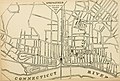
 1826 map Springfield Massachusetts bySamuelBowles BPL 14876.png 575 × 697; 631 KB
-
 1875 View of Springfield Massachusetts byBailey BPL 10183.png 935 × 690; 1.2 MB
-
 1920 Richards standard atlas of the city of Springfield BPL 11059.png 1,020 × 705; 1.19 MB
-
 Atlas of Massachusetts LOC 2013591316-17.jpg 4,974 × 5,977; 4.41 MB
-

-
 Ireland, the 3rd Parish of West Springfield, Holyoke (1827).png 3,904 × 2,597; 13.35 MB
-
-
 Lageplan der Springfield Waffenfabrik.jpg 574 × 816; 145 KB
-
 Ma02 109.gif 636 × 379; 28 KB
-
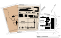 Map of Springfield Armory campus.svg 931 × 580; 224 KB
-
 Map of the city of Springfield Massachusetts (2674583005).jpg 1,551 × 2,000; 2.84 MB
-
 Map of the city of Springfield, Massachusetts. LOC 77691674.jpg 9,404 × 8,674; 11.69 MB
-
 Plan of Springfield (7537850880).jpg 1,618 × 2,000; 2.64 MB
-
 Race and ethnicity 2010- Springfield (5559842699).png 3,009 × 3,009; 2.45 MB
-
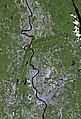 Springfield ma from space.jpg 576 × 848; 83 KB
-
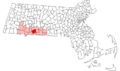 Springfield ma highlight.png 788 × 466; 54 KB
-
 Springfield, 1827 - surveyed by direction of the town, 1826 LOC 2011589318.jpg 4,826 × 5,941; 4.38 MB
-
 Springfield, 1827 - surveyed by direction of the town, 1826 LOC 2011589318.tif 4,826 × 5,941; 82.03 MB
-
 Springfield, Massachusetts 1955 Yellow Book.jpg 800 × 1,148; 284 KB
-
 Springfield-Chicopee-Holyoke Central Business Districts (1977 Census of Trade).jpg 1,330 × 1,676; 1.15 MB
-
 SpringfieldMA Neighborhoods.svg 254 × 223; 302 KB
-
 View of Springfield, Mass. (2675790314).jpg 9,416 × 7,151; 19.04 MB
-
 View of Springfield, Mass. 1875. LOC 75694606.jpg 11,216 × 8,400; 20.18 MB


.png)
_(14598054778).jpg)


.jpg)

.jpg)
.png)


.jpg)

.jpg)
