Category:Maps of San Juan Islands
Jump to navigation
Jump to search
English: The San Juan Islands are a part of the San Juan Archipelago in the northwest corner of the continental United States. The archipelago is split into two groups of islands based on national sovereignty. San Juan Islands are part of the U.S. state of Washington, while the Gulf Islands are part of the Canadian province of British Columbia.
Out of historical considerations and because the Gulf Islands may also been shown in the maps, this map category is placed in "Maps of islands of British Columbia" although previous border conflicts have long been resolved.
Media in category "Maps of San Juan Islands"
The following 13 files are in this category, out of 13 total.
-

-

-
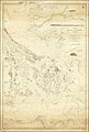 Admiralty Chart No 2689 Haro and Rosario Straits Surveyed By Captn. G.H. Richards, Published 1859.jpg 16,075 × 23,895; 66.24 MB
-
-
 Lummi Island locator map.svg 1,052 × 744; 232 KB
-
 Map of the San Juan Islands .gif 716 × 638; 35 KB
-
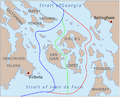 PigWar-boundaries.png 1,058 × 855; 637 KB
-
 San Juan Islands CattlePoint 2017 (34037510435).jpg 1,650 × 1,275; 173 KB
-
 San-Juan-Islands-with-Grid.svg 512 × 288; 209 KB
-
 SanJuanIslands-labelled-focusShaw.jpg 462 × 326; 53 KB
-
 Watmough Bay Map San Juan Islands (33852889251).jpg 1,650 × 1,284; 200 KB
-
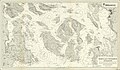
 West Sound - 1911 Admiralty Chart 2840.png 571 × 760; 1,012 KB
-
 Yellow3.png 351 × 251; 15 KB
.jpg)
_(1899)_(20430124030).jpg)


.jpg)


.jpg)

