Category:Maps of Ramsey County, North Dakota
Jump to navigation
Jump to search
Wikimedia category | |||||
| Upload media | |||||
| Instance of | |||||
|---|---|---|---|---|---|
| Category combines topics | |||||
| Ramsey County | |||||
county in North Dakota, United States   | |||||
| Instance of | |||||
| Named after | |||||
| Location | North Dakota | ||||
| Capital | |||||
| Inception |
| ||||
| Population |
| ||||
| Area |
| ||||
| Different from | |||||
| official website | |||||
 | |||||
Media in category "Maps of Ramsey County, North Dakota"
The following 20 files are in this category, out of 20 total.
-
 Map of North Dakota highlighting Ramsey County.svg 5,804 × 3,456; 56 KB
-
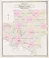 Map of Ramsey County, N.D., 1909.jpg 4,182 × 4,961; 17.81 MB
-
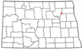
 ND Ramsey County Brocket.svg 990 × 765; 434 KB
-
 ND Ramsey County Churchs Ferry.svg 990 × 765; 434 KB
-
 ND Ramsey County Crary.svg 990 × 765; 434 KB
-
 ND Ramsey County Devils Lake.svg 990 × 765; 432 KB
-
 ND Ramsey County Edmore.svg 990 × 765; 434 KB
-
 ND Ramsey County Hampden.svg 990 × 765; 434 KB
-
 ND Ramsey County Lawton.svg 990 × 765; 434 KB
-
 ND Ramsey County Starkweather.svg 990 × 765; 434 KB
-
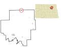
 NDMap-doton-Brocket.PNG 300 × 179; 11 KB
-
 NDMap-doton-ChurchsFerry.png 300 × 179; 11 KB
-
 NDMap-doton-DevilsLake.PNG 300 × 179; 11 KB
-
 NDMap-doton-Hampden.PNG 300 × 179; 11 KB
-
 NDMap-doton-Lawton.PNG 300 × 179; 11 KB
-
 NDMap-doton-Starkweather.PNG 300 × 179; 11 KB
-
 Ramsey County census tracts by percent Asian, 2020.svg 626 × 446; 159 KB
-
 Ramsey County census tracts by percent Black, 2020.svg 626 × 446; 160 KB
-
 Ramsey County census tracts by percent Native, 2020.svg 626 × 446; 158 KB
-
 Ramsey County census tracts by percent non-Hispanic White, 2020.svg 626 × 446; 157 KB


