Category:Maps of Pyongyang
Jump to navigation
Jump to search
Wikimedia category | |||||
| Upload media | |||||
| Instance of | |||||
|---|---|---|---|---|---|
| Category combines topics | |||||
| Pyongyang | |||||
capital city of North Korea    .jpg) .jpg) .jpg)    | |||||
| Pronunciation audio | |||||
| Instance of | |||||
| Part of | |||||
| Location | |||||
| Located in or next to body of water | |||||
| Heritage designation |
| ||||
| Significant event |
| ||||
| Population |
| ||||
| Area |
| ||||
| Elevation above sea level |
| ||||
| Replaces |
| ||||
| Different from | |||||
 | |||||
Subcategories
This category has the following 2 subcategories, out of 2 total.
- Districts of Pyongyang SVG maps (24 F)
P
Media in category "Maps of Pyongyang"
The following 26 files are in this category, out of 26 total.
-
-
 1922 Japanese map of Pyongyang, Korea.tif 12,974 × 18,768; 696.67 MB
-
 1946 Map of Pyongyang, Army Map Service, US Army.jpg 4,168 × 4,481; 7.74 MB
-
 Map of Pyongyang - 1946 - Glossary.jpg 240 × 400; 108 KB
-
 Admiralty Chart No 1257 Changsan Got to Apnok Kang or Yalu Chiang, Published 1965.jpg 11,092 × 16,203; 56.72 MB
-
 Capital (Clear).svg 709 × 709; 28 KB
-
 Capital (LT).svg 709 × 709; 32 KB
-
 Divisions of North Korea (EN) Pyongang Clear.svg 709 × 709; 28 KB
-
 DPRK2006 Pyongyang.png 235 × 242; 3 KB
-
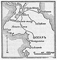
 Heijo map circa 1930.PNG 1,097 × 1,646; 1.23 MB
-
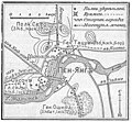
 Heijo map in 1934.jpg 2,990 × 2,227; 1.64 MB
-
 Islands of Pyongyang.svg 726 × 600; 9 KB
-
 Map of ground level electric transport in Pyongyang.png 12,481 × 13,519; 49.06 MB
-
 Map of Pyongyang Folklore Park.png 1,928 × 1,688; 1.18 MB
-
 Map of Pyongyang Trams.png 4,205 × 3,266; 512 KB
-
 Mapa Pjongjangu.png 280 × 200; 20 KB
-
 NK-pyongyang3.png 488 × 524; 10 KB
-
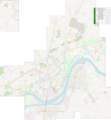
 OSM Map Pyongyang 2012.jpg 2,173 × 1,813; 601 KB
-
 Pyongyang North Korea.png 413 × 492; 9 KB
-
 Pyongyang territorial changes in 2010.svg 181 × 150; 11 KB
-
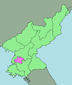
 Pyongyang-chikhalsi in North Korea.svg 1,606 × 1,616; 767 KB
-
-
-
 평양동부1(1932)(10000-1).jpg 3,644 × 2,500; 5.71 MB
-
 평양동부2(1932)(10000-1).jpg 3,644 × 2,500; 4.95 MB
-
 평양서부2(1932)(10000-1).jpg 3,644 × 2,500; 5.84 MB
_-_Geographicus_-_SinoJapanese-japan-1910.jpg)


.svg)


.jpg)
.jpg)
(10000-1).jpg)
(10000-1).jpg)
(10000-1).jpg)
.svg)
_Pyongang_Clear.svg)