Category:Maps of Paris in the 1930s
Jump to navigation
Jump to search
Media in category "Maps of Paris in the 1930s"
The following 22 files are in this category, out of 22 total.
-

-

-
 Population density of Paris, 1931 - Demographia.svg 512 × 293; 185 KB
-

-

-
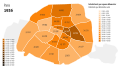 Population density of Paris, 1936 - Demographia.svg 512 × 293; 183 KB
-
 Paris in Brockhaus 1937 cropped.jpg 2,619 × 1,577; 3.27 MB
-
 Paris in Brockhaus 1937.jpg 2,624 × 1,680; 2.61 MB
-

-

-

-
 Département de la Seine. Densité de la population. Année 1931 - btv1b84593075.jpg 9,132 × 7,474; 7.32 MB
-
 Exposition coloniale internationale de Paris. Paris Musées 20230613101034.jpg 8,792 × 6,792; 39.52 MB
-
 Imprimerie Dufrénoy, Paris, 1937 - Gallica.jpg 10,350 × 7,646; 13.23 MB
-
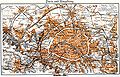
 Lange diercke sachsen europaeische landschaften paris.jpg 1,258 × 936; 726 KB
-
 Monsanglant, Plan de Paris, 1936 - Gallica.jpg 15,780 × 10,972; 21.86 MB
-
 Paris by Geographical Section, General Staff, War Office, 1944 - Stanford Libraries.jpg 16,003 × 13,310; 34.3 MB
-
 Paris by Geographical Section, General Staff, War Office, 1944 - Stanford Libraries.tif 16,003 × 13,310; 203.13 MB
-
 Paris by Plasal, 1937 - Gallica.jpg 8,936 × 6,778; 9.23 MB
-
 Taride, Chemin de fer métropolitain. Paris et banlieue, 1934 (01) - Gallica.jpg 16,434 × 13,347; 51.08 MB
-
 Taride, Chemin de fer métropolitain. Paris et banlieue, 1934 (02) - Gallica.jpg 16,477 × 13,379; 50.85 MB
-
 Éditeur Guilmin, Plan de Paris divisé en 20 arrondissements de Paris.jpg 9,072 × 7,212; 7.21 MB


_-_Gallica.jpg)
_-_Gallica.jpg)
