Category:Maps of Northern Cape municipalities with 2016 borders
Jump to navigation
Jump to search
This category contains maps of municipalities in the Northern Cape province of South Africa that show the the municipal borders as they are after the municipal election of 3 August 2016. This is the most recent demarcation.
Media in category "Maps of Northern Cape municipalities with 2016 borders"
The following 41 files are in this category, out of 41 total.
-
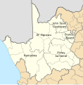 Map of the Northern Cape with districts labelled (2016).svg 750 × 764; 610 KB
-
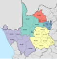
 Map of the Northern Cape with municipalities blank (2016).svg 750 × 764; 1.02 MB
-
 Blank map of the Northern Cape (2016).svg 699 × 716; 513 KB
-
 Map of the Northern Cape with Dawid Kruiper highlighted (2016).svg 750 × 764; 565 KB
-
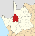
 Map of the Northern Cape with Dikgatlong highlighted (2016).svg 750 × 764; 547 KB
-
 Map of the Northern Cape with Emthanjeni highlighted (2016).svg 750 × 764; 549 KB
-
 Map of South Africa with Frances Baard highlighted (2016).svg 809 × 709; 736 KB
-
 Map of the Northern Cape with Frances Baard highlighted (2016).svg 750 × 764; 553 KB
-
 Map of the Northern Cape with Ga-Segonyana highlighted (2016).svg 750 × 764; 544 KB
-
 Map of the Northern Cape with Gamagara highlighted (2016).svg 750 × 764; 542 KB
-
 Map of the Northern Cape with Hantam highlighted (2016).svg 750 × 764; 563 KB
-
 Map of the Northern Cape with Joe Morolong highlighted (2016).svg 750 × 764; 553 KB
-
 Map of South Africa with John Taolo Gaetsewe highlighted (2016).svg 809 × 709; 736 KB
-
 Map of the Northern Cape with John Taolo Gaetsewe highlighted (2016).svg 750 × 764; 552 KB
-
 Map of the Northern Cape with Kai !Garib highlighted (2016).svg 750 × 764; 552 KB
-
 Map of the Northern Cape with Kamiesberg highlighted (2016).svg 750 × 764; 555 KB
-
 Map of the Northern Cape with Kareeberg highlighted (2016).svg 750 × 764; 550 KB
-
 Map of the Northern Cape with Karoo Hoogland highlighted (2016).svg 750 × 764; 560 KB
-
 Map of the Northern Cape with Kgatelopele highlighted (2016).svg 750 × 764; 543 KB
-
 Map of the Northern Cape with !Kheis highlighted (2016).svg 750 × 764; 554 KB
-
 Map of the Northern Cape with Khâi-Ma highlighted (2016).svg 750 × 764; 551 KB
-
 Map of the Northern Cape with Magareng highlighted (2016).svg 750 × 764; 545 KB
-
-

-
 Map of the Northern Cape with Nama Khoi highlighted (2016).svg 750 × 764; 554 KB
-
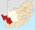 Map of South Africa with Namakwa highlighted (2016).svg 809 × 709; 773 KB
-
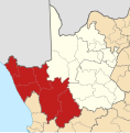 Map of the Northern Cape with Namakwa highlighted (2016).svg 750 × 764; 608 KB
-
 Map of the Northern Cape with Phokwane highlighted (2016).svg 750 × 764; 543 KB
-
 Map of South Africa with Pixley ka Seme highlighted (2016).svg 809 × 709; 755 KB
-
 Map of the Northern Cape with Pixley ka Seme highlighted (2016).svg 750 × 764; 579 KB
-
 Map of the Northern Cape with Renosterberg highlighted (2016).svg 750 × 764; 547 KB
-
 Map of the Northern Cape with Richtersveld highlighted (2016).svg 750 × 764; 555 KB
-
 Map of the Northern Cape with Siyancuma highlighted (2016).svg 750 × 764; 564 KB
-
 Map of the Northern Cape with Siyathemba highlighted (2016).svg 750 × 764; 555 KB
-
 Map of the Northern Cape with Sol Plaatje highlighted (2016).svg 750 × 764; 547 KB
-
 Map of the Northern Cape with Thembelihle highlighted (2016).svg 750 × 764; 550 KB
-
 Map of the Northern Cape with Tsantsabane highlighted (2016).svg 750 × 764; 550 KB
-
 Map of the Northern Cape with Ubuntu highlighted (2016).svg 750 × 764; 550 KB
-
 Map of the Northern Cape with Umsobomvu highlighted (2016).svg 750 × 764; 549 KB
-
 Map of South Africa with ZF Mgcawu highlighted (2016).svg 809 × 709; 760 KB
-
 Map of the Northern Cape with ZF Mgcawu highlighted (2016).svg 750 × 764; 587 KB
.svg)
.svg)
.svg)
.svg)
.svg)
.svg)
.svg)
.svg)
.svg)
.svg)
.svg)
.svg)
.svg)
.svg)
.svg)
.svg)
.svg)
.svg)
.svg)
.svg)
.svg)
.svg)
.svg)
.svg)
.svg)
.svg)
.svg)
.svg)
.svg)
.svg)
.svg)
.svg)
.svg)
.svg)
.svg)
.svg)
.svg)
.svg)
.svg)
.svg)
.svg)